School nearby Детский Сад Игрушки
Israel
School nearby Детский Сад Игрушки
Детский Сад Игрушки
12, Weizman Street, Bat Yam, IL Израиль
contacts phone
:
+972
Latitude:
32.0283217
, Longitude:
34.7508261
larger map & directions
read more
nearest School
262 m
Детский Сад Карамельки
ירושלים 53, בת ים
School
read more
331 m
DJ School Audio Live
Yerushalayim Street 40, Bat Yam
School
read more
472 m
Детский сад Смайлик Бат ям גן ילדים סמייליק בת ים
Halper Street 21, Bat Yam
School
read more
476 m
Школа Нахшоним
Ha-Rav Herzog Street 9, Bat Yam
School
read more
538 m
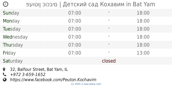
פעוטון כוכבים | Детский сад Кохавим
Balfour Street 32, Bat Yam
School
read more
543 m
קלאוזנר 5 בת ים
-6,, Klausner Street 2, Bat Yam
School
read more
577 m
ביס איתמר בן אבי
Kehilat Canada Street 3, Tel Aviv-Yafo
School
read more
577 m
Школа Итамар Бен Ави
Kehilat Canada Street 3, Tel Aviv-Yafo
School
read more
724 m
גן מפרשית
Khelmit Street 7, Bat Yam
School
read more
725 m
גן מעון וצהרון "רונית"
דניאל 37, בת ים
School
read more
725 m
גן מעון וצהרון רונית
Daniel Street 37, Bat Yam
School
read more
811 m
התיכון
HaRav Kuk Street 8, Bat Yam
School
read more
811 m
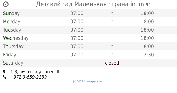
Детский сад Маленькая страна
טשרניחובסקי 1-3, בת ים
School
read more
835 m
Волшебная страна Детский сад
Mivtsa Sinai Street 6, Bat Yam
School
read more
883 m
Средняя Школа Хашмонаим
фикус 19, Tel Aviv-Yafo
School
read more
888 m
Средняя Школа Хашмонаим
I'rit Street 19, Tel Aviv-Yafo
School
read more
955 m
מרכז הצעירים בת ים
רהב, בת ים
School
read more
955 m
Государственно-религиозная школа Тахкемони
Herzl Street 58, Bat Yam
School
read more
963 m
גן אגמית
סומקן 13, תל אביב יפו
School
read more
982 m
גן אילנית
Sumkan Street 13, Tel Aviv-Yafo
School
read more
982 m
גן אילנית
סומקן 13, תל אביב יפו
School
read more
1.01 km
Ульпан
Rahav Street 7, Bat Yam
School
read more
1.14 km
גן אפרסק
אצ"ל 52, חולון
School
read more
1.144 km
גן דובדבן
Ezel street 58, Holon
School
read more
1.144 km
גן דובדבן
אצ"ל 58, חולון
School
read more
📑
all categories
Accounting
Administrative area level 1
Administrative area level 2
Airport
Amusement park
Aquarium
Art gallery
Atm
Bakery
Bank
Bar
Beauty salon
Bicycle store
Book store
Bowling alley
Bus station
Cafe
Campground
Car dealer
Car rental
Car repair
Car wash
Casino
Cemetery
Church
City hall
Clothing store
Colloquial area
Convenience store
Country
Courthouse
Dentist
Department store
Doctor
Electrician
Electronics store
Embassy
Establishment
Finance
Fire station
Florist
Food
Funeral home
Furniture store
Gas station
General contractor
Grocery or supermarket
Gym
Hair care
Hardware store
Health
Hindu Temple
Home goods store
Hospital
Insurance agency
Intersection
Jewelry store
Laundry
Lawyer
Library
Light rail station
Liquor store
Local government office
Locality
Locksmith
Lodging
Meal delivery
Meal takeaway
Mosque
Movie rental
Movie theater
Moving company
Museum
Natural feature
Neighborhood
Night club
Painter
Park
Parking
Pet store
Pharmacy
Physiotherapist
Place of worship
Plumber
Point of interest
Police
Political
Post office
Premise
Real estate agency
Restaurant
Roofing contractor
Route
Rv park, camping
School
Shoe store
Shopping mall
Spa
Stadium
Storage
Store
Subpremise
Subway station
Supermarket
Synagogue
Taxi stand
Train station
Transit station
Travel agency
University
Veterinary care
Zoo
administrative area level 3
administrative area level 4
sublocality level 1
↑