School nearby בית ספר שדה - עין גדי
Coronavirus disease (COVID-19) Situation
confirmed cases
4841772
deaths
12707
Israel
School nearby בית ספר שדה - עין גדי
בית ספר שדה - עין גדי
Ein Gedi, Israel
contacts phone
:
+972 8-658-4288
website:
www.teva.org.il
Latitude:
31.4693111
, Longitude:
35.3948171
larger map & directions
read more
nearest School
1.998 km
תיכון עין גדי
Ein Gedi
School
read more
20.293 km
Library of Umm Al Kheir
Upper Umm Al Kheir Street
School
read more
21.675 km
مدرسة الكندي
شارع الكندي بني نعيم الخليل،
School
read more
25.097 km
مدرسة شهداء الحرم الاساسية للبنات
31°31'51.4"N, 东环五巷, 龙岩市
School
read more
28.552 km
Ort sports hall
Yoshiyahu Street 12-16, Arad
School
read more
28.568 km
צור אורט ערד
Yoshiyahu Street 4, Arad
School
read more
28.568 km
צור אורט ערד
יאשיהו 4, ערד
School
read more
28.612 km
Chabad Talmud Torah
Yoshiyahu Street 12, Arad
School
read more
28.621 km
מקיף אורט ערד
אורט, ערד
School
read more
28.628 km
ביס מקיף אורט
Yoshiyahu Street 4, Arad
School
read more
28.77 km
גני בית יעקב
Sha'ul ha-Melekh Street 9, Arad
School
read more
28.77 km
גני בית יעקב
שאול המלך 9, ערד
School
read more
29.166 km
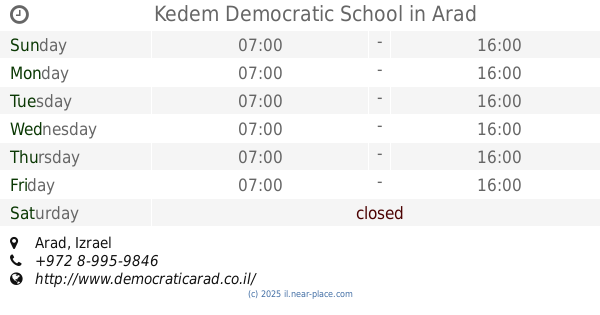
Kedem Democratic School
Arad
School
read more
29.166 km
ביס דמוקרטי קדם
ערד
School
read more
29.177 km
School Obiyat
هندازة
School
read more
29.245 km
גן ההרפתקאות
Atad Street, Arad
School
read more
29.245 km
גן ההרפתקאות
אטד, ערד
School
read more
29.47 km
בית ספר טללים והגנים
חן 38, ערד
School
read more
29.47 km
בית ספר טללים והגנים
Hen Street 38, Arad
School
read more
29.571 km
مدرسة ام سلمونة الاساسية المختلطة
School
read more
30.745 km
روضة وادي رحال المختلطة
Abdalla Ibrahim
School
read more
30.755 km
مدرسة واد رحال الثانوية المختلطة
Abdalla Ibrahim
School
read more
30.848 km
ישיבה תיכונית אות נווה שמואל עש שמואל אהערמן
Israel
School
read more
33.165 km
אל פורעה א'
אל פורעה
School
read more
50.043 km
Leman Achai
Nachal Lachish Ramat 40/7, בית שמש
School
read more
📑
all categories
Accounting
Administrative area level 1
Administrative area level 2
Airport
Amusement park
Aquarium
Art gallery
Atm
Bakery
Bank
Bar
Beauty salon
Bicycle store
Book store
Bowling alley
Bus station
Cafe
Campground
Car dealer
Car rental
Car repair
Car wash
Casino
Cemetery
Church
City hall
Clothing store
Colloquial area
Convenience store
Country
Courthouse
Dentist
Department store
Doctor
Electrician
Electronics store
Embassy
Establishment
Finance
Fire station
Florist
Food
Funeral home
Furniture store
Gas station
General contractor
Grocery or supermarket
Gym
Hair care
Hardware store
Health
Hindu Temple
Home goods store
Hospital
Insurance agency
Intersection
Jewelry store
Laundry
Lawyer
Library
Light rail station
Liquor store
Local government office
Locality
Locksmith
Lodging
Meal delivery
Meal takeaway
Mosque
Movie rental
Movie theater
Moving company
Museum
Natural feature
Neighborhood
Night club
Painter
Park
Parking
Pet store
Pharmacy
Physiotherapist
Place of worship
Plumber
Point of interest
Police
Political
Post office
Premise
Real estate agency
Restaurant
Roofing contractor
Route
Rv park, camping
School
Shoe store
Shopping mall
Spa
Stadium
Storage
Store
Subpremise
Subway station
Supermarket
Synagogue
Taxi stand
Train station
Transit station
Travel agency
University
Veterinary care
Zoo
administrative area level 3
administrative area level 4
sublocality level 1
↑