School nearby בית למעצב ביס לתפירה ותדמיתנות
Israel
School nearby בית למעצב ביס לתפירה ותדמיתנות
בית למעצב ביס לתפירה ותדמיתנות
1, Sha'ar Palmer Street, Haifa, Haifa, IL Израиль
contacts phone
:
+972 4-682-7327
website:
www.tofrim.com
Latitude:
32.8198381
, Longitude:
35.0003702
larger map & directions
read more
nearest School
118 m
המרכז לצילום אומנותי
הנמל 33, חיפה
School
read more
118 m
המרכז לצילום אומנותי
Ha-Namal Street 33, Haifa
School
read more
197 m
Общежитие Ульпана Эцион
Израиль, Ha-Namal Street 21, Haifa
School
read more
204 m
Beit Bubot Art Studio and Gallery
Natan Street 8, Haifa
School
read more
219 m
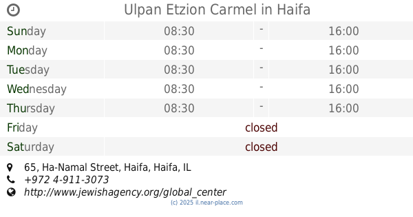
Ulpan Etzion Carmel
Ha-Namal Street 65, Haifa
School
read more
256 m
המכללה העסקית לניהול וסחר בינלאומי
דרך העצמאות 53, חיפה
School
read more
256 m
המכללה העסקית לניהול וסחר בינלאומי
Derech HaAtsma'ut 53, Haifa
School
read more
261 m
School of Puppetry Theatre
Ha-Namal Street 69, Haifa
School
read more
261 m
School of Puppetry Theatre
הנמל 69, חיפה
School
read more
449 m
Hiwar School
Haifa
School
read more
507 m
בית ספר מעלות לשעבר
Ma'alot HaNevi'im Street, Haifa
School
read more
620 m
Carmel High School
Sderot HaMeginim 76, Haifa
School
read more
623 m
ביס כרמל
חיפה
School
read more
671 m
مدرسة الاخوة
Kiesarya Street 18, Haifa
School
read more
756 m
ביס הכרמליטים
חיפה
School
read more
757 m
Ульпан
Y.L. Perets Street 20, Haifa
School
read more
777 m
בית ארדשתיין
אשקלון 6, חיפה
School
read more
780 m
Бейт Оле, агентство Сохнут
Израиль, Ashkelon Street 8, Haifa
School
read more
830 m
מכון רביב
שדרות בן גוריון 21, חיפה
School
read more
963 m
Вишенка-3
הגנים 16, חיפה
School
read more
963 m
Вишенка-3
HaGanim Street 16, Haifa
School
read more
993 m
בית הספר הריאלי העברי בחיפה, תיכון הדר
Shmaryahu Levin Street 15, Haifa
School
read more
1.003 km
ריאלי הדר
שמריהו לוין 19, חיפה
School
read more
1.003 km
ריאלי הדר
Shmaryahu Levin Street 19, Haifa
School
read more
1.067 km
The Hebrew Reali School, Tichon Hadar
25,, Shmaryahu Levin Street 23, Haifa
School
read more
📑
all categories
Accounting
Administrative area level 1
Administrative area level 2
Airport
Amusement park
Aquarium
Art gallery
Atm
Bakery
Bank
Bar
Beauty salon
Bicycle store
Book store
Bowling alley
Bus station
Cafe
Campground
Car dealer
Car rental
Car repair
Car wash
Casino
Cemetery
Church
City hall
Clothing store
Colloquial area
Convenience store
Country
Courthouse
Dentist
Department store
Doctor
Electrician
Electronics store
Embassy
Establishment
Finance
Fire station
Florist
Food
Funeral home
Furniture store
Gas station
General contractor
Grocery or supermarket
Gym
Hair care
Hardware store
Health
Hindu Temple
Home goods store
Hospital
Insurance agency
Intersection
Jewelry store
Laundry
Lawyer
Library
Light rail station
Liquor store
Local government office
Locality
Locksmith
Lodging
Meal delivery
Meal takeaway
Mosque
Movie rental
Movie theater
Moving company
Museum
Natural feature
Neighborhood
Night club
Painter
Park
Parking
Pet store
Pharmacy
Physiotherapist
Place of worship
Plumber
Point of interest
Police
Political
Post office
Premise
Real estate agency
Restaurant
Roofing contractor
Route
Rv park, camping
School
Shoe store
Shopping mall
Spa
Stadium
Storage
Store
Subpremise
Subway station
Supermarket
Synagogue
Taxi stand
Train station
Transit station
Travel agency
University
Veterinary care
Zoo
administrative area level 3
administrative area level 4
sublocality level 1
↑