School nearby ביס אילנות
Israel
School nearby ביס אילנות
ביס אילנות
הרצליה, ישראל
contacts phone
:
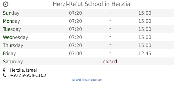
+972 9-950-2584
website:
www.ilanot.herzliya.org.il
Latitude:
32.1782579
, Longitude:
34.8501398
larger map & directions
read more
nearest School
339 m
Herzel School
A.L. Ziso Street 9, Herzliya
School
read more
353 m
Herzl-Re'ut School
Herzliya
School
read more
353 m
בי"ס הרצל רעות
הרצליה
School
read more
373 m
Reut Junior High
13, A.L. Ziso Street 11, Herzliya
School
read more
433 m
School Tali Ra'anana
Ha-Prakhim Street 21, Ra'anana
School
read more
465 m
Tali School Raanana
Ha-Prakhim Street 21, Ra'anana
School
read more
473 m
הבית של מילי
אנילביץ', הרצליה
School
read more
473 m
הבית של מילי
Anielewicz Street, Herzliya
School
read more
478 m
Afik Kindergarten
קורן 41, הרצליה
School
read more
478 m
Afik Kindergarten
Koren Street 41, Herzliya
School
read more
611 m
Yohanani
Ha-Hagana Street 64, Herzliya
School
read more
611 m
ביס יוחנני
ההגנה 64, הרצליה
School
read more
624 m
משפחתון פזית
הדר 51, הרצליה
School
read more
624 m
משפחתון פזית
Hadar Street 51, Herzliya
School
read more
790 m
תיכון דתי לחינוך ים וסביבה אחיה
הרצליה
School
read more
794 m
תיכון אחיה ממ"ד
Herzliya
School
read more
794 m
תיכון אחיה ממ"ד
הרצליה
School
read more
832 m
בית ספר פעמונים רעננה
הפעמונים 11, רעננה
School
read more
849 m
בית הספר פעמונים
הפעמונים 18, רעננה
School
read more
849 m
Pa'amonim School
Ha-Pa'amonim Street 18, Ra'anana
School
read more
860 m
Dor High School
Revivim Street 1, Herzliya
School
read more
998 m
תיכון אביב
הפרחים 1, רעננה
School
read more
1.012 km
גן ארבל
י.ל. ברוך 43, הרצליה
School
read more
1.274 km
פלד יפה - גן טל
טשרניחובסקי 28, הרצליה
School
read more
1.274 km
פלד יפה - גן טל
Tchernikhovski Street 28, Herzliya
School
read more
📑
all categories
Accounting
Administrative area level 1
Administrative area level 2
Airport
Amusement park
Aquarium
Art gallery
Atm
Bakery
Bank
Bar
Beauty salon
Bicycle store
Book store
Bowling alley
Bus station
Cafe
Campground
Car dealer
Car rental
Car repair
Car wash
Casino
Cemetery
Church
City hall
Clothing store
Colloquial area
Convenience store
Country
Courthouse
Dentist
Department store
Doctor
Electrician
Electronics store
Embassy
Establishment
Finance
Fire station
Florist
Food
Funeral home
Furniture store
Gas station
General contractor
Grocery or supermarket
Gym
Hair care
Hardware store
Health
Hindu Temple
Home goods store
Hospital
Insurance agency
Intersection
Jewelry store
Laundry
Lawyer
Library
Light rail station
Liquor store
Local government office
Locality
Locksmith
Lodging
Meal delivery
Meal takeaway
Mosque
Movie rental
Movie theater
Moving company
Museum
Natural feature
Neighborhood
Night club
Painter
Park
Parking
Pet store
Pharmacy
Physiotherapist
Place of worship
Plumber
Point of interest
Police
Political
Post office
Premise
Real estate agency
Restaurant
Roofing contractor
Route
Rv park, camping
School
Shoe store
Shopping mall
Spa
Stadium
Storage
Store
Subpremise
Subway station
Supermarket
Synagogue
Taxi stand
Train station
Transit station
Travel agency
University
Veterinary care
Zoo
administrative area level 3
administrative area level 4
sublocality level 1
↑