Restaurant nearby Tulip
Israel
Restaurant nearby Tulip
Tulip
Unnamed Road, בועיינה-נוג'ידאת Israel
contacts phone
:
+972
Latitude:
32.8059082
, Longitude:
35.3684379
read more
nearest Restaurant
382 m
מסעדת אבו מאגד
Bu'eine Nujeidat
Restaurant
read more
3.369 km
مطعم وحمص احمد
Tur'an
Restaurant
read more
3.539 km
Nimer restaurant
צומת גולני, מצפה טורען
Restaurant
read more
3.539 km
מסעדת נימר
צומת גולני, מצפה טורען
Restaurant
read more
3.831 km
ביצה אלמרכז
Uzeir
Restaurant
read more
3.831 km
ביצה אלמרכז
עוזייר
Restaurant
read more
4.097 km
מסעדת ושווארמה נימר
תחנת דלק פז, טורעאן
Restaurant
read more
4.277 km
Fresh Take Away
fresh take away, Eilabun
Restaurant
read more
4.382 km
יונס
Tur'an
Restaurant
read more
4.409 km
מרחב אירוח גלילאקו
7, הררית
Restaurant
read more
4.409 km
מרחב אירוח גלילאקו
7, Hararit
Restaurant
read more
4.415 km
Shawarma Abu Elias
Eilabun
Restaurant
read more
4.479 km
אלטייב
עוזייר
Restaurant
read more
4.511 km
מפגש צומת החביתה
Israel
Restaurant
read more
4.54 km
Grill Eilaboun
Eilabun
Restaurant
read more
4.546 km
גריל עילבון
Eilabun
Restaurant
read more
4.616 km
Shobak
806, עיילבון
Restaurant
read more
4.819 km
Restaurant elBalad
Uzeir
Restaurant
read more
4.819 km
מסעדת אלבלד
עוזייר
Restaurant
read more
4.998 km
Макдоналдс
צומת גולני, גולני
Restaurant
read more
5.18 km
עזיז מלך הקבב
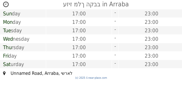
Unnamed Road, Arraba
Restaurant
read more
5.307 km
אל מוכתאר
Golani Intersection, Tiberias
Restaurant
read more
5.307 km
El Muchtar
Golani Intersection, Tiberias
Restaurant
read more
6.32 km
Mifgash 77
Mashhad
Restaurant
read more
6.324 km
מפגש 77
משהד
Restaurant
read more
📑
all categories
Accounting
Administrative area level 1
Administrative area level 2
Airport
Amusement park
Aquarium
Art gallery
Atm
Bakery
Bank
Bar
Beauty salon
Bicycle store
Book store
Bowling alley
Bus station
Cafe
Campground
Car dealer
Car rental
Car repair
Car wash
Casino
Cemetery
Church
City hall
Clothing store
Colloquial area
Convenience store
Country
Courthouse
Dentist
Department store
Doctor
Electrician
Electronics store
Embassy
Establishment
Finance
Fire station
Florist
Food
Funeral home
Furniture store
Gas station
General contractor
Grocery or supermarket
Gym
Hair care
Hardware store
Health
Hindu Temple
Home goods store
Hospital
Insurance agency
Intersection
Jewelry store
Laundry
Lawyer
Library
Light rail station
Liquor store
Local government office
Locality
Locksmith
Lodging
Meal delivery
Meal takeaway
Mosque
Movie rental
Movie theater
Moving company
Museum
Natural feature
Neighborhood
Night club
Painter
Park
Parking
Pet store
Pharmacy
Physiotherapist
Place of worship
Plumber
Point of interest
Police
Political
Post office
Premise
Real estate agency
Restaurant
Roofing contractor
Route
Rv park, camping
School
Shoe store
Shopping mall
Spa
Stadium
Storage
Store
Subpremise
Subway station
Supermarket
Synagogue
Taxi stand
Train station
Transit station
Travel agency
University
Veterinary care
Zoo
administrative area level 3
administrative area level 4
sublocality level 1
↑