Restaurant nearby פיצה 25
Israel
Restaurant nearby פיצה 25
פיצה 25
הרב כהנמן 100, בני ברק ישראל
contacts phone
:
+972
Latitude:
32.0782128
, Longitude:
34.8418344
read more
nearest Restaurant
19 m
פיצה טוונטי פייב
הרב כהנמן 100, בני ברק
Restaurant
read more
85 m
Ariks
HaRav Kahanman Street 104, Bnei Brak
Restaurant
read more
127 m
שנדליר
Shlomo ha-Melekh Street 12, Bnei Brak
Restaurant
read more
129 m
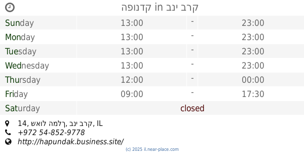
הפונדק
שאול המלך 14, בני ברק
Restaurant
read more
151 m
שווארמה פון
Shlomo ha-Melekh Street 12, Bnei Brak
Restaurant
read more
225 m
הפינה הירושלמית
שמשון הגיבור 8, בני ברק
Restaurant
read more
292 m
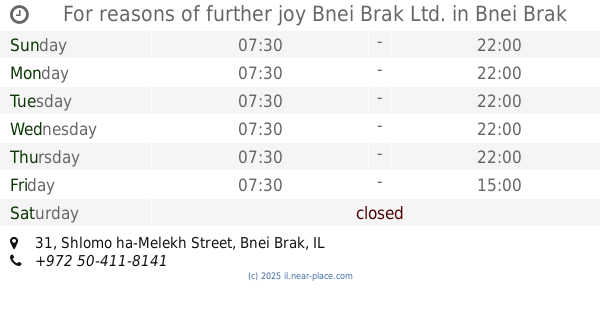
For reasons of further joy Bnei Brak Ltd.
Shlomo ha-Melekh Street 31, Bnei Brak
Restaurant
read more
375 m
המזנון
7, גוש עציון, גבעת שמואל
Restaurant
read more
446 m
גולד קייטרינג
Giborei Israel Street 16, Bnei Brak
Restaurant
read more
462 m
Pizza Greg
David Ben Gurion Street 11, Giv'at Shmuel
Restaurant
read more
466 m
Deli Libar's
Har Sinai Street 15, Bnei Brak
Restaurant
read more
477 m
Momento Pizza Time
David Ben Gurion Street 20, Giv'at Shmuel
Restaurant
read more
488 m
פלאפל צ'ומה
דוד בן גוריון 20, גבעת שמואל
Restaurant
read more
488 m
פלאפל צ׳ומה
David Ben Gurion Street 20, Giv'at Shmuel
Restaurant
read more
585 m
Fitzohi Idai
Kehilot Ya'akov Street 37, Bnei Brak
Restaurant
read more
585 m
פיצוחי ידעי
קהילות יעקב 37, בני ברק
Restaurant
read more
626 m
פלאפל
אמרי חיים 32, בני ברק
Restaurant
read more
771 m
מאפה תימן
Doctor Natan Birnboim Street 23, Bnei Brak
Restaurant
read more
934 m
Sopranos pizza
HaNasi Street 17, Giv'at Shmuel
Restaurant
read more
934 m
פיצה סופרנוס
הנשיא 17, גבעת שמואל
Restaurant
read more
1.033 km
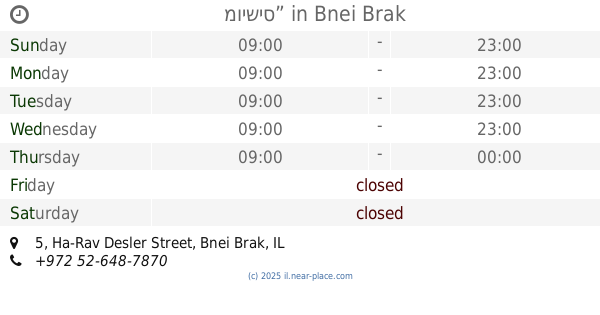
מוישיס”
Ha-Rav Desler Street 5, Bnei Brak
Restaurant
read more
1.046 km
מסעדת הלל
ראב"ד, בני ברק
Restaurant
read more
1.055 km
Falafel Rabbi Akiva grill meats
Rabi Akiva Street 122, Bnei Brak
Restaurant
read more
1.084 km
Kondtorih Schimmel
Ra'abad Street 32, Bnei Brak
Restaurant
read more
1.116 km
Stisl - Jewish food center
HaRav Shach Street 14, Bnei Brak
Restaurant
read more
📑
all categories
Accounting
Administrative area level 1
Administrative area level 2
Airport
Amusement park
Aquarium
Art gallery
Atm
Bakery
Bank
Bar
Beauty salon
Bicycle store
Book store
Bowling alley
Bus station
Cafe
Campground
Car dealer
Car rental
Car repair
Car wash
Casino
Cemetery
Church
City hall
Clothing store
Colloquial area
Convenience store
Country
Courthouse
Dentist
Department store
Doctor
Electrician
Electronics store
Embassy
Establishment
Finance
Fire station
Florist
Food
Funeral home
Furniture store
Gas station
General contractor
Grocery or supermarket
Gym
Hair care
Hardware store
Health
Hindu Temple
Home goods store
Hospital
Insurance agency
Intersection
Jewelry store
Laundry
Lawyer
Library
Light rail station
Liquor store
Local government office
Locality
Locksmith
Lodging
Meal delivery
Meal takeaway
Mosque
Movie rental
Movie theater
Moving company
Museum
Natural feature
Neighborhood
Night club
Painter
Park
Parking
Pet store
Pharmacy
Physiotherapist
Place of worship
Plumber
Point of interest
Police
Political
Post office
Premise
Real estate agency
Restaurant
Roofing contractor
Route
Rv park, camping
School
Shoe store
Shopping mall
Spa
Stadium
Storage
Store
Subpremise
Subway station
Supermarket
Synagogue
Taxi stand
Train station
Transit station
Travel agency
University
Veterinary care
Zoo
administrative area level 3
administrative area level 4
sublocality level 1
↑