Restaurant nearby אנניה
Israel
Restaurant nearby אנניה
אנניה
Shpinoza Street 7, Ashkelon Израиль
contacts phone
:
+972
Latitude:
31.6613592
, Longitude:
34.5679449
read more
nearest Restaurant
434 m
Chiang Mai
Sderot David Ben Gurion 21, Ashkelon
Restaurant
read more
468 m
מקדונלדס קניון גירון אשקלון
שדרות דוד בן גוריון 23, אשקלון
Restaurant
read more
500 m
פלאפל לוי
Ha-Gvura Street 16, Ashkelon
Restaurant
read more
614 m
סטקיית עשור
Yehuda Halevi Street 34, Ashkelon
Restaurant
read more
616 m
פיצה סמילנו
Yehuda Halevi Street 36, Ashkelon
Restaurant
read more
676 m
הגחלים
הגבורה 1, אשקלון
Restaurant
read more
676 m
הגחלים
Ha-Gvura Street 1, Ashkelon
Restaurant
read more
681 m
Cafe Cafe
הנשיא 82-84, אשקלון
Restaurant
read more
681 m
Cafe Cafe
Ha-Nasi Street 82-84, Ashkelon
Restaurant
read more
729 m
Meluka -מלוקה
אלי כהן 21, אשקלון
Restaurant
read more
729 m
אלעפיה אקדמיה
אלי כהן 21, אשקלון
Restaurant
read more
777 m
I.a.l Barzilai hospital cafeteria
Ha-Histadrut Street 2, Ashkelon
Restaurant
read more
777 m
י.ע.ל קפטריה בית חולים ברזילי
ההסתדרות 2, אשקלון
Restaurant
read more
787 m
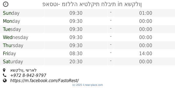
פאסטו- מזללה איטלקית חלבית
אשקלון
Restaurant
read more
800 m
פיצה מון אמור
Bialik Street 45, Ashkelon
Restaurant
read more
887 m
Burger Grill
Jabotinski Street 1, Ashkelon
Restaurant
read more
951 m
Burgeranch
Ashkelon
Restaurant
read more
951 m
Pizza Hut
Ashkelon
Restaurant
read more
951 m
Freddies
Ashkelon
Restaurant
read more
1.004 km
Aziz Restaurant
Eli Cohen Street 0, Ashkelon
Restaurant
read more
1.019 km
פסטו
שד' בן גוריון 1, אשקלון
Restaurant
read more
1.13 km
פיצה ביאנקה
Eli Cohen Street 34, Ashkelon
Restaurant
read more
1.141 km
ביאנקה - Bianca
Eli Cohen Street 34, Ashkelon
Meal delivery
Restaurant
Food
Point of interest
Establishment
read more
1.213 km
סושי בר
סיני 4, אשקלון
Restaurant
read more
1.213 km
sushi bar
Sinai Street 4, Ashkelon
Restaurant
read more
📑
all categories
Accounting
Administrative area level 1
Administrative area level 2
Airport
Amusement park
Aquarium
Art gallery
Atm
Bakery
Bank
Bar
Beauty salon
Bicycle store
Book store
Bowling alley
Bus station
Cafe
Campground
Car dealer
Car rental
Car repair
Car wash
Casino
Cemetery
Church
City hall
Clothing store
Colloquial area
Convenience store
Country
Courthouse
Dentist
Department store
Doctor
Electrician
Electronics store
Embassy
Establishment
Finance
Fire station
Florist
Food
Funeral home
Furniture store
Gas station
General contractor
Grocery or supermarket
Gym
Hair care
Hardware store
Health
Hindu Temple
Home goods store
Hospital
Insurance agency
Intersection
Jewelry store
Laundry
Lawyer
Library
Light rail station
Liquor store
Local government office
Locality
Locksmith
Lodging
Meal delivery
Meal takeaway
Mosque
Movie rental
Movie theater
Moving company
Museum
Natural feature
Neighborhood
Night club
Painter
Park
Parking
Pet store
Pharmacy
Physiotherapist
Place of worship
Plumber
Point of interest
Police
Political
Post office
Premise
Real estate agency
Restaurant
Roofing contractor
Route
Rv park, camping
School
Shoe store
Shopping mall
Spa
Stadium
Storage
Store
Subpremise
Subway station
Supermarket
Synagogue
Taxi stand
Train station
Transit station
Travel agency
University
Veterinary care
Zoo
administrative area level 3
administrative area level 4
sublocality level 1
↑