Restaurant nearby מסוב Massov
Coronavirus disease (COVID-19) Situation
confirmed cases
4841772
deaths
12707
Israel
Restaurant nearby מסוב Massov
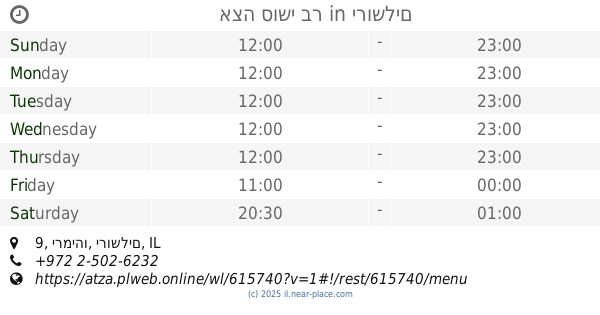
מסוב Massov
Jaffa Street 234, Jerusalem Израиль
contacts phone
:
+972
Latitude:
31.7891603
, Longitude:
35.2012258
read more
nearest Restaurant
70 m
קורוס על האש
סנטר 1, ירמיהו 43, ירושלים
Restaurant
read more
239 m
בורגרס בר
תחנה מרכזית, יפו 222, ירושלים
Restaurant
read more
286 m
Mister Chips
Jaffa Street 218, Jerusalem
Restaurant
read more
297 m
Pizza Italiano
Jerusalem
Restaurant
read more
570 m
Skyline restaurant מסעדת סקייליין
זאב וילנאי 4, ירושלים
Restaurant
read more
599 m
Shulhan Hasultan
Yermiyahu Street 17, Jerusalem
Restaurant
read more
726 m
פטריקס
סינימה סיטי, שדרות יצחק רבין 10, ירושלים
Restaurant
read more
754 m
תרזה
ירושלים
Restaurant
read more
763 m
קינג ג'ורג' סינמה סיטי ירושלים
שדרות יצחק רבין 10, ירושלים
Restaurant
read more
800 m
Tzipora Jerusalem
מתחם סינמה סיטי, שד' יצחק רבין 10, ירושלים
Restaurant
read more
842 m
אצה סושי בר
רוממה, ירמיהו 9, ירושלים
Restaurant
read more
885 m
אוכל לנזקקים עזרה וחסד משנת יעקב
HaTurim Street 7, Jerusalem
Restaurant
read more
890 m
מוטי'ס
Shamgar Street 21, Jerusalem
Restaurant
read more
908 m
פיש בייט
שמגר 16, ירושלים
Restaurant
read more
986 m
ресторан сима
5, Ha-Rav Shmuel Barukh Street 1, Jerusalem
Restaurant
read more
1.06 km
דוויני פיתה בר
בית יעקב 6, ירושלים
Restaurant
read more
1.07 km
שיפודי מוריס
Beit Ya'akov Street 4, Jerusalem
Restaurant
read more
1.071 km
ג'קט פוטטו בר
בית יעקב 5, ירושלים
Restaurant
read more
1.084 km
וואחד פלאפל
Beit Ya'akov Street 5, Jerusalem
Restaurant
read more
1.089 km
Carmey Hair
Agripas Street 72, Jerusalem
Restaurant
read more
1.098 km
בורגר מרקט - Burger Market
הערמונים 3, ירושלים
Restaurant
read more
1.112 km
Jacobs
HaArmonim Street 4, Jerusalem
Restaurant
read more
1.123 km
השלושה
אגריפס 68, ירושלים
Restaurant
read more
1.13 km
ממפיס
Agripas Street 68, Jerusalem
Restaurant
read more
1.144 km
Selfys Yogurt and Salad
אגריפס 111, ירושלים
Restaurant
read more
📑
all categories
Accounting
Administrative area level 1
Administrative area level 2
Airport
Amusement park
Aquarium
Art gallery
Atm
Bakery
Bank
Bar
Beauty salon
Bicycle store
Book store
Bowling alley
Bus station
Cafe
Campground
Car dealer
Car rental
Car repair
Car wash
Casino
Cemetery
Church
City hall
Clothing store
Colloquial area
Convenience store
Country
Courthouse
Dentist
Department store
Doctor
Electrician
Electronics store
Embassy
Establishment
Finance
Fire station
Florist
Food
Funeral home
Furniture store
Gas station
General contractor
Grocery or supermarket
Gym
Hair care
Hardware store
Health
Hindu Temple
Home goods store
Hospital
Insurance agency
Intersection
Jewelry store
Laundry
Lawyer
Library
Light rail station
Liquor store
Local government office
Locality
Locksmith
Lodging
Meal delivery
Meal takeaway
Mosque
Movie rental
Movie theater
Moving company
Museum
Natural feature
Neighborhood
Night club
Painter
Park
Parking
Pet store
Pharmacy
Physiotherapist
Place of worship
Plumber
Point of interest
Police
Political
Post office
Premise
Real estate agency
Restaurant
Roofing contractor
Route
Rv park, camping
School
Shoe store
Shopping mall
Spa
Stadium
Storage
Store
Subpremise
Subway station
Supermarket
Synagogue
Taxi stand
Train station
Transit station
Travel agency
University
Veterinary care
Zoo
administrative area level 3
administrative area level 4
sublocality level 1
↑