Restaurant nearby מסעדת נסיב
Coronavirus disease (COVID-19) Situation
confirmed cases
4841772
deaths
12707
Israel
Restaurant nearby מסעדת נסיב
מסעדת נסיב
ישוב, כפר יאסיף, 24908, ישראל
contacts phone
:
+972 4-991-0942
website:
www.2eat.co.il
Latitude:
32.9575094
, Longitude:
35.1596726
larger map & directions
read more
nearest Restaurant
96 m
Soarmh the coals and sharp
70, Kafr Yasif
Restaurant
read more
107 m
HookahBar & Restaurant
כפר יאסיף
Restaurant
read more
109 m
Abu Fawzi Hummus
Kafr Yasif
Restaurant
Food
Point of interest
Establishment
read more
116 m
Abu Fawzi
Kafr Yasif
Restaurant
read more
137 m
Restaurant arabesque
Kafr Yasif
Restaurant
read more
165 m
פלאפל עווד
כפר יסיף, Kafr Yasif
Restaurant
read more
165 m
Falafel Awad - פלאפל עווד
כפר יסיף, Kafr Yasif
Restaurant
read more
200 m
Shawerma Johnny Al lobnany
כפר יאסיף
Restaurant
read more
304 m
השווארמה של חאזן בכפר יאסיף
כביש 70, כפר יאסיף
Restaurant
read more
367 m
Lamsa
כפר יאסיף
Restaurant
read more
370 m
Abu Adham Restaurant
Kafr Yasif
Restaurant
read more
370 m
מסעדת אבו אדהם
כפר יאסיף
Restaurant
read more
442 m
חומוס אבו מאהר
כפר יאסיף
Restaurant
read more
455 m
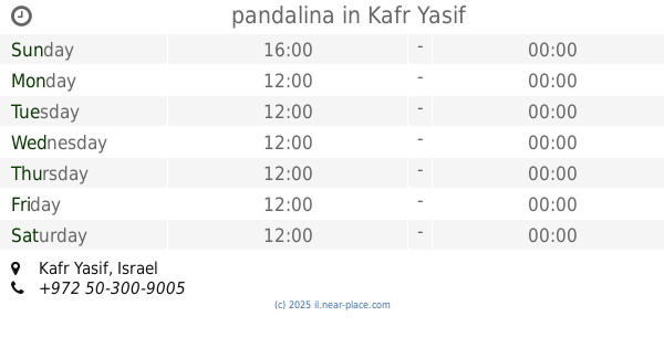
pandalina
Kafr Yasif
Restaurant
read more
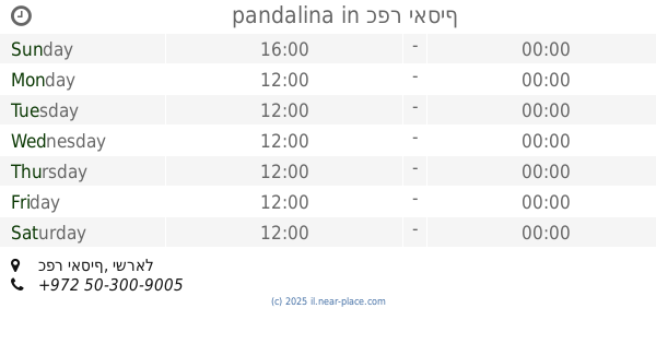
455 m
pandalina
כפר יאסיף
Restaurant
read more
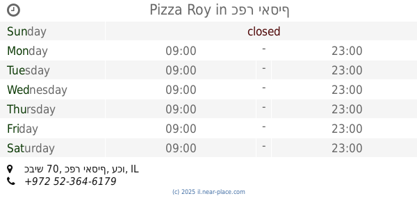
533 m
Pizza Roy
כביש 70, כפר יאסיף
Restaurant
read more
541 m
מאפיית אלבאבור
Sultan El Atrash Street, Abu Snan
Restaurant
read more
610 m
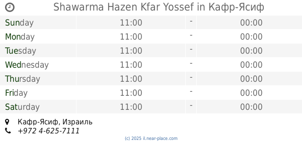
Shawarma Hazen Kfar Yossef
Kafr Yasif
Restaurant
read more
737 m
كنتاكي كفرياسيف
شارع 70, Kafr Yasif
Restaurant
read more
737 m
קנטאקי
شارع 70, כפר יאסיף
Restaurant
read more
985 m
Falafel Awad
Kafr Yasif
Restaurant
read more
1.011 km
Pizza Roy
Abu Snan
Restaurant
read more
1.019 km
לפה לבנונית
135, אבו סנאן
Restaurant
read more
1.019 km
לפה לבנונית
135 Street, Abu Snan
Restaurant
read more
1.062 km
גרנאדה
כפר יסיף, Kafr Yasif
Restaurant
read more
📑
all categories
Accounting
Administrative area level 1
Administrative area level 2
Airport
Amusement park
Aquarium
Art gallery
Atm
Bakery
Bank
Bar
Beauty salon
Bicycle store
Book store
Bowling alley
Bus station
Cafe
Campground
Car dealer
Car rental
Car repair
Car wash
Casino
Cemetery
Church
City hall
Clothing store
Colloquial area
Convenience store
Country
Courthouse
Dentist
Department store
Doctor
Electrician
Electronics store
Embassy
Establishment
Finance
Fire station
Florist
Food
Funeral home
Furniture store
Gas station
General contractor
Grocery or supermarket
Gym
Hair care
Hardware store
Health
Hindu Temple
Home goods store
Hospital
Insurance agency
Intersection
Jewelry store
Laundry
Lawyer
Library
Light rail station
Liquor store
Local government office
Locality
Locksmith
Lodging
Meal delivery
Meal takeaway
Mosque
Movie rental
Movie theater
Moving company
Museum
Natural feature
Neighborhood
Night club
Painter
Park
Parking
Pet store
Pharmacy
Physiotherapist
Place of worship
Plumber
Point of interest
Police
Political
Post office
Premise
Real estate agency
Restaurant
Roofing contractor
Route
Rv park, camping
School
Shoe store
Shopping mall
Spa
Stadium
Storage
Store
Subpremise
Subway station
Supermarket
Synagogue
Taxi stand
Train station
Transit station
Travel agency
University
Veterinary care
Zoo
administrative area level 3
administrative area level 4
sublocality level 1
↑