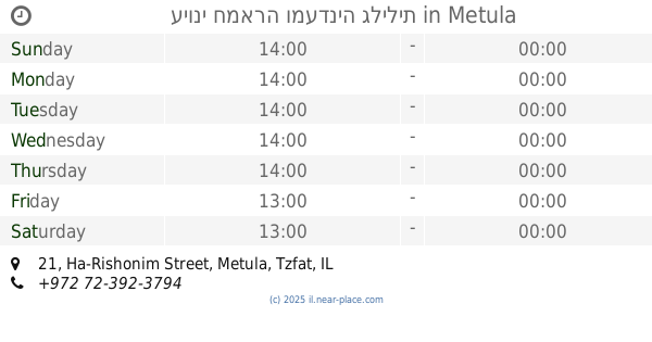
Restaurant nearby לישנסקי מאז 1936
Israel
Restaurant nearby לישנסקי מאז 1936
לישנסקי מאז 1936
42, הראשונים, מטולה, צפת, IL ישראל
contacts phone
:
+972 4-699-7184
website:
he-il.facebook.com
Latitude:
33.2808732
, Longitude:
35.579449
larger map & directions
read more
nearest Restaurant
138 m
עיוני חמארה ומעדניה גלילית
Ha-Rishonim Street 21, Metula
Restaurant
read more
215 m
אפללוס פלאפל מקומי
הראשונים 49, מטולה
Restaurant
read more
215 m
אפללוס פלאפל מקומי
Ha-Rishonim Street 49, Metula
Restaurant
read more
366 m
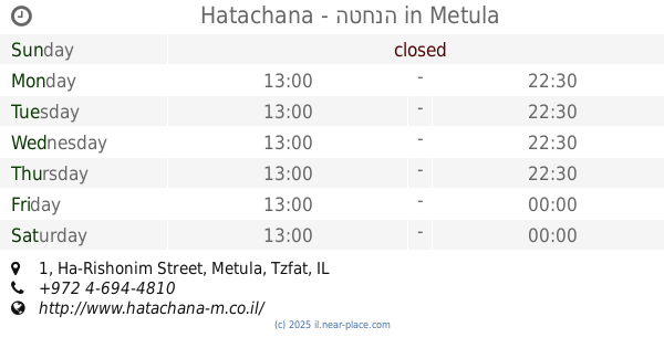
Hatachana - הטחנה
Ha-Rishonim Street 1, Metula
Restaurant
read more
404 m
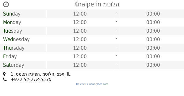
קנייפה
סמטת קנייפה 1, מטולה
Restaurant
read more
404 m
Knaipe
סמטת קנייפה 1, מטולה
Restaurant
read more
1.353 km
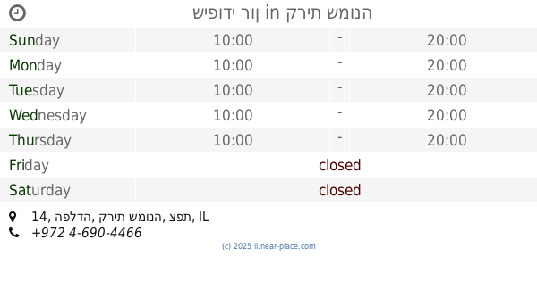
Водопад Аюн
מטולה
Restaurant
read more
4.247 km
חומוס באצבע
Unnamed Road, Kfar Giladi
Restaurant
read more
4.612 km
استراحة الجزيرة
Lebanon
Restaurant
read more
6.698 km
הגינה של לייבה
Tel Hai Street 277, Qiryat Shemona
Restaurant
read more
6.728 km
השניצליה
90 8, קרית שמונה
Restaurant
read more
6.756 km
פסטה בסטה
מתחם יוסף, כביש 99, קרית שמונה
Restaurant
read more
7.149 km
McDonald's
HaZikaron Garden, Ma'ayan Baruch
Restaurant
read more
7.228 km
Klompus
מתחם דור אלון, כביש 99, הגושרים
Restaurant
read more
7.713 km
מקסיקנו טורטיה בר - קרית שמונה
Ha-Maccabim St 16 Qiryat Shemona IL 10200, המכבים 16, קרית שמונה
Restaurant
read more
7.771 km
חומוס אליהו
תל חי 61, קרית שמונה
Restaurant
read more
7.841 km
Макдоналдс
קניון קרית שמונה, קרית שמונה
Restaurant
read more
8.18 km
פיש 99
Emek Hulah
Restaurant
read more
8.905 km
בורקס קריית שמונה
104, הרצל 72, Qiryat Shemona
Restaurant
read more
9.209 km
בורגרים קרית שמונה
Qiryat Shemona
Restaurant
read more
9.391 km
שיפודי רון
הפלדה 14, קרית שמונה
Restaurant
read more
9.468 km
בורגרים - קרית שמונה - שפר בע"מ
Kiryat Shmona Street 1, Holon
Restaurant
read more
11.335 km
פלריגים פלוס שלטי פלריג
דרך החמניות 42, Sde Nehemia
Restaurant
read more
12.334 km
Dining Room Kfar Blum
Kfar Blum
Restaurant
read more
12.344 km
Uma / אומה
Israel
Restaurant
read more
📑
all categories
Accounting
Administrative area level 1
Administrative area level 2
Airport
Amusement park
Aquarium
Art gallery
Atm
Bakery
Bank
Bar
Beauty salon
Bicycle store
Book store
Bowling alley
Bus station
Cafe
Campground
Car dealer
Car rental
Car repair
Car wash
Casino
Cemetery
Church
City hall
Clothing store
Colloquial area
Convenience store
Country
Courthouse
Dentist
Department store
Doctor
Electrician
Electronics store
Embassy
Establishment
Finance
Fire station
Florist
Food
Funeral home
Furniture store
Gas station
General contractor
Grocery or supermarket
Gym
Hair care
Hardware store
Health
Hindu Temple
Home goods store
Hospital
Insurance agency
Intersection
Jewelry store
Laundry
Lawyer
Library
Light rail station
Liquor store
Local government office
Locality
Locksmith
Lodging
Meal delivery
Meal takeaway
Mosque
Movie rental
Movie theater
Moving company
Museum
Natural feature
Neighborhood
Night club
Painter
Park
Parking
Pet store
Pharmacy
Physiotherapist
Place of worship
Plumber
Point of interest
Police
Political
Post office
Premise
Real estate agency
Restaurant
Roofing contractor
Route
Rv park, camping
School
Shoe store
Shopping mall
Spa
Stadium
Storage
Store
Subpremise
Subway station
Supermarket
Synagogue
Taxi stand
Train station
Transit station
Travel agency
University
Veterinary care
Zoo
administrative area level 3
administrative area level 4
sublocality level 1
↑