Restaurant nearby חתוכה מרקט
Israel
Restaurant nearby חתוכה מרקט
חתוכה מרקט
13, Ha-Hagana Street, Ramat Gan, IL Israel
contacts phone
:
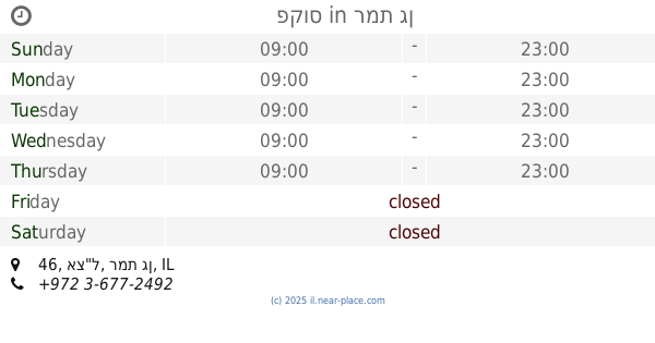
+972 3-676-9922
website:
www.facebook.com
Latitude:
32.0697104
, Longitude:
34.8342861
larger map & directions
read more
nearest Restaurant
302 m
פקוס
אצ"ל 46, רמת גן
Restaurant
read more
344 m
המטבח של טל
Pinkas Street 6, Ramat Gan
Restaurant
read more
418 m
Santa Katerina
2, Har Sinai Street, Tel Aviv-Yafo
Restaurant
read more
543 m
Café Café
מרכז מרום נווה, תרצה 19, רמת גן
Cafe
Restaurant
Food
Point of interest
Store
Establishment
read more
559 m
Roladin
תרצה 19, רמת גן
Restaurant
read more
561 m
פלאפל
אמרי חיים 32, בני ברק
Restaurant
read more
567 m
מן בורגר
תרצה 19, רמת גן
Restaurant
read more
567 m
מן בורגר
Tirzah Street 19, Ramat Gan
Restaurant
read more
579 m
אושי אושי
Khayim Landau Street 7, Ramat Gan
Restaurant
read more
596 m
Burgeranch
חיים לנדאו 7A, רמת גן
Restaurant
read more
613 m
מאפה תימן
Doctor Natan Birnboim Street 23, Bnei Brak
Restaurant
read more
621 m
Fitzohi Idai
Kehilot Ya'akov Street 37, Bnei Brak
Restaurant
read more
621 m
פיצוחי ידעי
קהילות יעקב 37, בני ברק
Restaurant
read more
631 m
חומוס בויה
Rosh Pina Street 9, Ramat Gan
Restaurant
read more
742 m
שניצל ציון
Derech Negba 39, Ramat Gan
Restaurant
read more
770 m
Deli Libar's
Har Sinai Street 15, Bnei Brak
Restaurant
read more
867 m
Yemenite Falafel King
Har Sinai Street 6, Bnei Brak
Restaurant
read more
916 m
אייס פוינט רמת גן
הרא"ה 186, רמת גן
Restaurant
read more
983 m
חומוס ירושלים
Sderot Yerushalayim 54, Ramat Gan
Restaurant
read more
1.079 km
הפונדק
שאול המלך 14, בני ברק
Restaurant
read more
1.141 km
Ariks
HaRav Kahanman Street 104, Bnei Brak
Restaurant
read more
1.145 km
שווארמה פון
Shlomo ha-Melekh Street 12, Bnei Brak
Restaurant
read more
1.181 km
פיצה טוונטי פייב
הרב כהנמן 100, בני ברק
Restaurant
read more
1.181 km
פיצה טוונטי פייב
HaRav Kahanman Street 100, Bnei Brak
Restaurant
read more
1.255 km
Spicy Grill Bar
Ha-roeh, Haroe Street 133, Ramat Gan
Restaurant
read more
📑
all categories
Accounting
Administrative area level 1
Administrative area level 2
Airport
Amusement park
Aquarium
Art gallery
Atm
Bakery
Bank
Bar
Beauty salon
Bicycle store
Book store
Bowling alley
Bus station
Cafe
Campground
Car dealer
Car rental
Car repair
Car wash
Casino
Cemetery
Church
City hall
Clothing store
Colloquial area
Convenience store
Country
Courthouse
Dentist
Department store
Doctor
Electrician
Electronics store
Embassy
Establishment
Finance
Fire station
Florist
Food
Funeral home
Furniture store
Gas station
General contractor
Grocery or supermarket
Gym
Hair care
Hardware store
Health
Hindu Temple
Home goods store
Hospital
Insurance agency
Intersection
Jewelry store
Laundry
Lawyer
Library
Light rail station
Liquor store
Local government office
Locality
Locksmith
Lodging
Meal delivery
Meal takeaway
Mosque
Movie rental
Movie theater
Moving company
Museum
Natural feature
Neighborhood
Night club
Painter
Park
Parking
Pet store
Pharmacy
Physiotherapist
Place of worship
Plumber
Point of interest
Police
Political
Post office
Premise
Real estate agency
Restaurant
Roofing contractor
Route
Rv park, camping
School
Shoe store
Shopping mall
Spa
Stadium
Storage
Store
Subpremise
Subway station
Supermarket
Synagogue
Taxi stand
Train station
Transit station
Travel agency
University
Veterinary care
Zoo
administrative area level 3
administrative area level 4
sublocality level 1
↑