Restaurant nearby השניצל והפלאפל
Israel
Restaurant nearby השניצל והפלאפל
השניצל והפלאפל
Ahituv, Израиль
contacts phone
:
+972
Latitude:
32.3853744
, Longitude:
34.9921278
larger map & directions
read more
nearest Restaurant
785 m
פיצה מאמא
Harimon Street, Ahituv
Restaurant
read more
1.838 km
אל ווזיר
מסעדה ליד להבות חביבה
Restaurant
read more
1.876 km
פסיפס גבינות
Bereshit Street 18, Ometz
Restaurant
read more
4.238 km
Pine essence of this food
Israel
Restaurant
read more
4.238 km
פיצה הלא
Gat Street, משולש
Restaurant
read more
4.238 km
הסביח של אורן
Israel
Restaurant
read more
4.368 km
חומוס פול אבו סאלמה
574, Zemer
Restaurant
read more
4.369 km
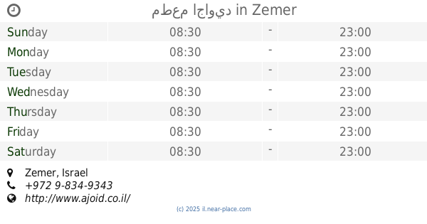
مطعم اجاويد
Zemer
Restaurant
read more
4.679 km
אג׳אויד - חוות אלבואדי
Zemer
Restaurant
read more
4.679 km
אג׳אויד - חוות אלבואדי
זמר
Restaurant
read more
4.868 km
מאפיית זמר
Ibthan Street, Zemer
Restaurant
read more
4.91 km
חומוס פול נסים
Bir Baqa Street, Baqa al-Gharbiyye
Restaurant
read more
5.069 km
השניצליה
קניון מול, אדם יקותיאל 12, חדרה
Meal takeaway
Restaurant
Food
Point of interest
Establishment
read more
5.076 km
Pizza Fix Hadera
7, Adam Yekuti'el Street, Hadera
Restaurant
read more
5.11 km
Bobble Nibski
Alqulfa Alrashdun Street, Baqa al-Gharbiyye
Restaurant
read more
5.432 km
המטבח הערבי
Elkasami Street, Baqa al-Gharbiyye
Restaurant
read more
5.728 km
Gebatoo
באקה אל-ע'רביה
Restaurant
read more
5.96 km
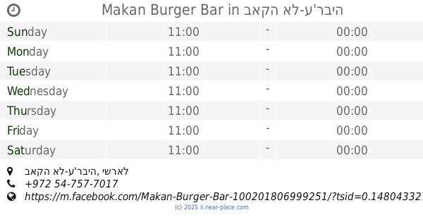
Makan Burger Bar
באקה אל-ע'רביה
Restaurant
read more
5.975 km
מסעדת עווני بونجور للمشاوي
אבן ח'לדון, באקה אל-ע'רביה
Restaurant
read more
6.017 km
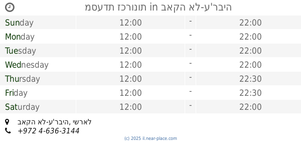
מסעדת זכרונות
באקה אל-ע'רביה
Restaurant
read more
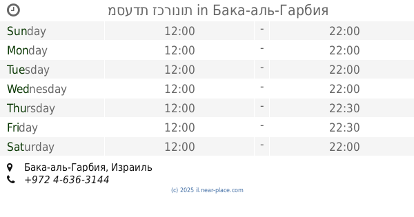
6.017 km
מסעדת זכרונות
Baqa al-Gharbiyye
Restaurant
read more
6.031 km
ביסאן מסעדה
Alkuds Street, Baqa al-Gharbiyye
Restaurant
read more
6.032 km
ונילה
Alkazaz Street, Baqa al-Gharbiyye
Restaurant
read more
6.157 km
Eduardo's Restaurant
HaAtsmaut Street 37, Haifa
Restaurant
read more
6.264 km
Domino's Pizza
Baka El Garbia
Restaurant
read more
📑
all categories
Accounting
Administrative area level 1
Administrative area level 2
Airport
Amusement park
Aquarium
Art gallery
Atm
Bakery
Bank
Bar
Beauty salon
Bicycle store
Book store
Bowling alley
Bus station
Cafe
Campground
Car dealer
Car rental
Car repair
Car wash
Casino
Cemetery
Church
City hall
Clothing store
Colloquial area
Convenience store
Country
Courthouse
Dentist
Department store
Doctor
Electrician
Electronics store
Embassy
Establishment
Finance
Fire station
Florist
Food
Funeral home
Furniture store
Gas station
General contractor
Grocery or supermarket
Gym
Hair care
Hardware store
Health
Hindu Temple
Home goods store
Hospital
Insurance agency
Intersection
Jewelry store
Laundry
Lawyer
Library
Light rail station
Liquor store
Local government office
Locality
Locksmith
Lodging
Meal delivery
Meal takeaway
Mosque
Movie rental
Movie theater
Moving company
Museum
Natural feature
Neighborhood
Night club
Painter
Park
Parking
Pet store
Pharmacy
Physiotherapist
Place of worship
Plumber
Point of interest
Police
Political
Post office
Premise
Real estate agency
Restaurant
Roofing contractor
Route
Rv park, camping
School
Shoe store
Shopping mall
Spa
Stadium
Storage
Store
Subpremise
Subway station
Supermarket
Synagogue
Taxi stand
Train station
Transit station
Travel agency
University
Veterinary care
Zoo
administrative area level 3
administrative area level 4
sublocality level 1
↑