Restaurant nearby הדר גאולה
Israel
Restaurant nearby הדר גאולה
הדר גאולה
Malki Street, Jerusalem, IL Israel
contacts phone
:
+972 2-538-2832
Latitude:
31.7720557
, Longitude:
35.2248205
larger map & directions
read more
nearest Restaurant
107 m
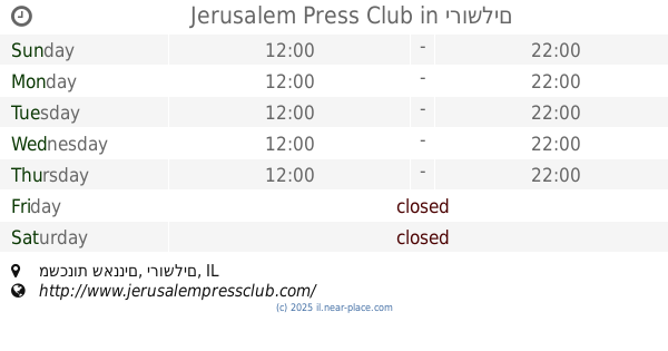
Jerusalem Press Club
משכנות שאננים, ירושלים
Restaurant
read more
466 m
פטטה Patata - Potato And Batata Dishes
דוד רמז 4, מתחם תחנת הרכבת הראשונה, Jerusalem
Restaurant
read more
540 m
מסעדת אדום
מתחם תחנת, דוד רמז 4, ירושלים
Restaurant
read more
577 m
JLM Local Sushi
10, King David, Jerusalem
Restaurant
read more
595 m
Station 9
מתחם התחנה הראשונה, דוד רמז 4, ירושלים
Restaurant
read more
687 m
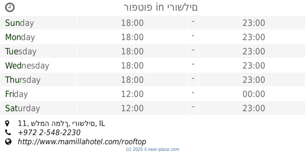
רופטופ
שלמה המלך 11, ירושלים
Restaurant
read more
716 m
מיאן נודלס
שלמה המלך 22, ירושלים
Restaurant
read more
776 m
Black Bar 'n' Burger
Queen Shlomziyon Street 18, Jerusalem
Restaurant
read more
799 m
Mangiare
Queen Shlomziyon Street 18, Jerusalem
Restaurant
read more
806 m
Al-Sultan Restaurant
Suq Aftimos #7, Jerusalem Old City
Restaurant
read more
841 m
Ben Sira Hummus
Ben Sira Street 3, Jerusalem
Restaurant
read more
934 m
BBB
35, Hillel Street, Jerusalem
Restaurant
read more
941 m
גבריאל
שמעון בן שטח 7, ירושלים
Restaurant
read more
971 m
Walia Ibex
ירושלים
Restaurant
read more
991 m
קמפאי סטריט ווק
Emek Refa'im Street 31, Jerusalem
Restaurant
read more
993 m
Rony's Pizza
Jaffa Street 25, Jerusalem
Restaurant
read more
1.007 km
Grill Bar
Ha-Soreg Street 1, Jerusalem
Restaurant
read more
1.007 km
גורמה Gourmet
Yosef Rivlin Street 18, Jerusalem
Restaurant
read more
1.04 km
צ'ילי פיצריה
הלל 28, ירושלים
Restaurant
read more
1.049 km
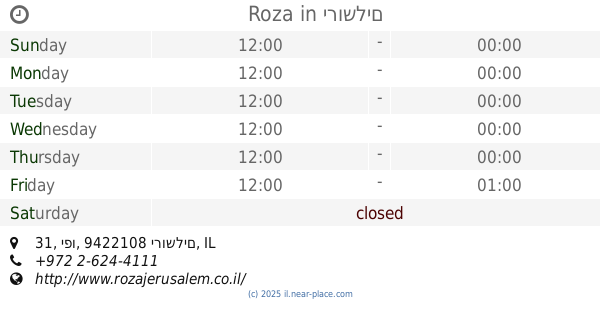
Roza
מתחם פיינגולד, יפו 31, ירושלים
Restaurant
read more
1.057 km
Hamishpaha
Yo'el Moshe Salomon Street 12, Jerusalem
Restaurant
read more
1.069 km
Caffit
Emek Refa'im Street 36, Jerusalem
Restaurant
read more
1.075 km
גורמנדיז
יואל משה סלומון 10, ירושלים
Restaurant
read more
1.173 km
מזנון סימיקו
המלך ג'ורג', ירושלים
Restaurant
read more
1.191 km
Shalom Falafel
Hillel Street 8, Jerusalem
Restaurant
read more
📑
all categories
Accounting
Administrative area level 1
Administrative area level 2
Airport
Amusement park
Aquarium
Art gallery
Atm
Bakery
Bank
Bar
Beauty salon
Bicycle store
Book store
Bowling alley
Bus station
Cafe
Campground
Car dealer
Car rental
Car repair
Car wash
Casino
Cemetery
Church
City hall
Clothing store
Colloquial area
Convenience store
Country
Courthouse
Dentist
Department store
Doctor
Electrician
Electronics store
Embassy
Establishment
Finance
Fire station
Florist
Food
Funeral home
Furniture store
Gas station
General contractor
Grocery or supermarket
Gym
Hair care
Hardware store
Health
Hindu Temple
Home goods store
Hospital
Insurance agency
Intersection
Jewelry store
Laundry
Lawyer
Library
Light rail station
Liquor store
Local government office
Locality
Locksmith
Lodging
Meal delivery
Meal takeaway
Mosque
Movie rental
Movie theater
Moving company
Museum
Natural feature
Neighborhood
Night club
Painter
Park
Parking
Pet store
Pharmacy
Physiotherapist
Place of worship
Plumber
Point of interest
Police
Political
Post office
Premise
Real estate agency
Restaurant
Roofing contractor
Route
Rv park, camping
School
Shoe store
Shopping mall
Spa
Stadium
Storage
Store
Subpremise
Subway station
Supermarket
Synagogue
Taxi stand
Train station
Transit station
Travel agency
University
Veterinary care
Zoo
administrative area level 3
administrative area level 4
sublocality level 1
↑