Restaurant nearby הבית של שרה ויפת
Israel
Restaurant nearby הבית של שרה ויפת
הבית של שרה ויפת
13, Yerushalaim Road, Ra'anana, Petach Tikva, IL Izrael
contacts phone
:
+972 9-772-8118
Latitude:
32.189694
, Longitude:
34.854881
larger map & directions
read more
nearest Restaurant
19 m
הבית של שרה ויפת
דרך ירושלים 13, רעננה
Restaurant
read more
414 m
הבית של יפת
דרך ירושלים 4, רעננה
Restaurant
read more
414 m
הבית של יפת
Yerushalaim Road 4, Ra'anana
Restaurant
read more
535 m
Bistro Bar 267 Menu
Ahuza Street 267, Ra'anana
Restaurant
read more
535 m
ביסטרו בר 267
אחוזה 267, רעננה
Restaurant
read more
604 m
Same Same
Ahuza Street 267, Ra'anana
Restaurant
Food
Point of interest
Establishment
read more
604 m
סיים סיים
אחוזה 267, רעננה
Restaurant
read more
623 m
מטעמי השטעטל Shtetl Delicatessen
אחוזה 267, רעננה
Restaurant
read more
623 m
Shtetl Delicatessen
Ahuza Street 267, Ra'anana
Restaurant
read more
632 m
Макдоналдс
Ahuza Street 267, Ra'anana
Restaurant
read more
632 m
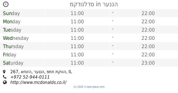
מקדונלדס
אחוזה 267, רעננה
Restaurant
read more
640 m
McDonald's
Ahuza Street 267, Ra'anana
Restaurant
Food
Point of interest
Establishment
read more
659 m
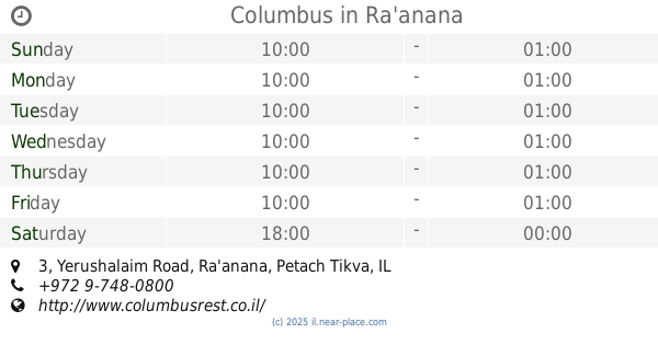
Columbus
Yerushalaim Road 3, Ra'anana
Restaurant
read more
659 m
קולומבוס
דרך ירושלים 3, רעננה
Restaurant
read more
672 m
לה קרולינה
רעננה
Restaurant
read more
676 m
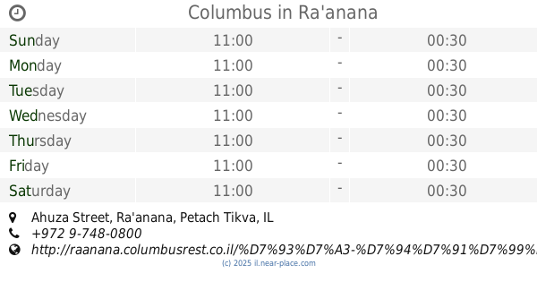
Columbus
Ahuza Street, Ra'anana
Restaurant
read more
802 m
Cafe Shlonsky
הנשיאים פינת שלונסקי 47, Ra'anana
Restaurant
read more
802 m
קפה שלונסקי
הנשיאים פינת שלונסקי 47, רעננה
Restaurant
read more
1.054 km
קפה סשה
Sasha Argov Street 25, Ra'anana
Restaurant
read more
1.972 km
Taboon and barbecue-estate
Ahuza Street 128, Ra'anana
Restaurant
read more
1.992 km
Alsenya
Ahuza Street 130, Ra'anana
Restaurant
read more
1.995 km
מסעדת נג'ימה
Bar Ilan Street 1, Ra'anana
Restaurant
Food
Point of interest
Establishment
read more
2.021 km
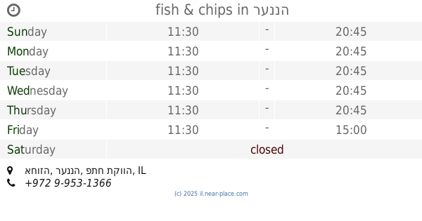
fish & chips
אחוזה, רעננה
Restaurant
read more
2.119 km
מסעדת נג'ימה
אליעזר יפה 3, רעננה
Restaurant
read more
2.466 km
שסטל
פרדס משותף 5, רעננה
Restaurant
read more
📑
all categories
Accounting
Administrative area level 1
Administrative area level 2
Airport
Amusement park
Aquarium
Art gallery
Atm
Bakery
Bank
Bar
Beauty salon
Bicycle store
Book store
Bowling alley
Bus station
Cafe
Campground
Car dealer
Car rental
Car repair
Car wash
Casino
Cemetery
Church
City hall
Clothing store
Colloquial area
Convenience store
Country
Courthouse
Dentist
Department store
Doctor
Electrician
Electronics store
Embassy
Establishment
Finance
Fire station
Florist
Food
Funeral home
Furniture store
Gas station
General contractor
Grocery or supermarket
Gym
Hair care
Hardware store
Health
Hindu Temple
Home goods store
Hospital
Insurance agency
Intersection
Jewelry store
Laundry
Lawyer
Library
Light rail station
Liquor store
Local government office
Locality
Locksmith
Lodging
Meal delivery
Meal takeaway
Mosque
Movie rental
Movie theater
Moving company
Museum
Natural feature
Neighborhood
Night club
Painter
Park
Parking
Pet store
Pharmacy
Physiotherapist
Place of worship
Plumber
Point of interest
Police
Political
Post office
Premise
Real estate agency
Restaurant
Roofing contractor
Route
Rv park, camping
School
Shoe store
Shopping mall
Spa
Stadium
Storage
Store
Subpremise
Subway station
Supermarket
Synagogue
Taxi stand
Train station
Transit station
Travel agency
University
Veterinary care
Zoo
administrative area level 3
administrative area level 4
sublocality level 1
↑