Restaurant nearby ג'חנון בכפר
Israel
Restaurant nearby ג'חנון בכפר
ג'חנון בכפר
האילנות 25, כפר סירקין ישראל
contacts phone
:
+972
Latitude:
32.0748929
, Longitude:
34.9252958
read more
nearest Restaurant
ג'חנון בכפר
Ha-Ilanot Street 25, Kfar Sirkin
Restaurant
read more
980 m
סירקין ספורטק
HaRav Ovadya Yosef Street 3, Petah Tikva
Restaurant
read more
980 m
סירקין ספורטק
הרב עובדיה יוסף 3, פתח תקווה
Restaurant
read more
1.327 km
Falafel booth
Shalom Tsalah Street 28, Petah Tikva
Restaurant
read more
1.327 km
פלאפל הבודקה
שלום צלח 28, פתח תקווה
Restaurant
read more
1.362 km
פיצה סופר מחיר
Shalom Tsalah Street 28-30, Petah Tikva
Restaurant
read more
1.362 km
פיצה סופר מחיר
שלום צלח 28-30, פתח תקווה
Restaurant
read more
1.365 km
הלב הרחב
Shalom Tsalah Street 30, Petah Tikva
Restaurant
read more
1.365 km
הלב הרחב
שלום צלח 30, פתח תקווה
Restaurant
read more
1.532 km
הלוחשת לסירים
עינת
Restaurant
read more
1.742 km
החומוס של ג'ינג'י
Einat
Restaurant
read more
1.748 km
Sushi Einat
Einat
Restaurant
read more
1.748 km
Sushi Einat
עינת
Restaurant
read more
2.188 km
Pizza
Elazar Fridman Street 9, Petah Tikva
Restaurant
read more
2.353 km
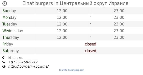
בורגרים עינת
Israel
Restaurant
read more
2.353 km
Einat burgers
Israel
Restaurant
read more
2.353 km
Einat burgers
מתחם דור אלון, Einat
Restaurant
Food
Point of interest
Establishment
read more
2.355 km
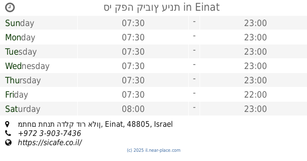
סי קפה קיבוץ עינת
מתחם תחנת הדלק דור אלון, Einat
Cafe
Restaurant
Food
Point of interest
Establishment
read more
2.356 km
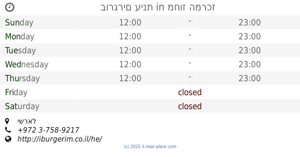
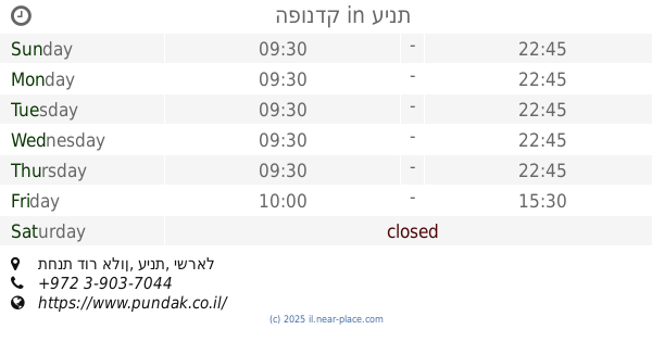
Hapundak
תחנת דור אלון, Einat
Restaurant
read more
2.356 km
הפונדק
תחנת דור אלון, עינת
Restaurant
read more
2.356 km
הפונדק
תחנת דור אלון, Einat
Restaurant
Food
Point of interest
Establishment
read more
2.358 km
Si Cafe -סי קפה מסעדה איטלקית
Israel
Restaurant
read more
2.359 km
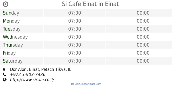
Si Cafe Einat
Dor Alon, Einat
Restaurant
Cafe
Food
Point of interest
Store
Establishment
read more
2.521 km
מאמי'ס
הנביאים 47, פתח תקווה
Restaurant
read more
2.877 km
Falafel King & Sons
שלמה המלך 35, ראש העין
Restaurant
read more
📑
all categories
Accounting
Administrative area level 1
Administrative area level 2
Airport
Amusement park
Aquarium
Art gallery
Atm
Bakery
Bank
Bar
Beauty salon
Bicycle store
Book store
Bowling alley
Bus station
Cafe
Campground
Car dealer
Car rental
Car repair
Car wash
Casino
Cemetery
Church
City hall
Clothing store
Colloquial area
Convenience store
Country
Courthouse
Dentist
Department store
Doctor
Electrician
Electronics store
Embassy
Establishment
Finance
Fire station
Florist
Food
Funeral home
Furniture store
Gas station
General contractor
Grocery or supermarket
Gym
Hair care
Hardware store
Health
Hindu Temple
Home goods store
Hospital
Insurance agency
Intersection
Jewelry store
Laundry
Lawyer
Library
Light rail station
Liquor store
Local government office
Locality
Locksmith
Lodging
Meal delivery
Meal takeaway
Mosque
Movie rental
Movie theater
Moving company
Museum
Natural feature
Neighborhood
Night club
Painter
Park
Parking
Pet store
Pharmacy
Physiotherapist
Place of worship
Plumber
Point of interest
Police
Political
Post office
Premise
Real estate agency
Restaurant
Roofing contractor
Route
Rv park, camping
School
Shoe store
Shopping mall
Spa
Stadium
Storage
Store
Subpremise
Subway station
Supermarket
Synagogue
Taxi stand
Train station
Transit station
Travel agency
University
Veterinary care
Zoo
administrative area level 3
administrative area level 4
sublocality level 1
↑