Restaurant nearby Ein ElWadi Restaurant
Coronavirus disease (COVID-19) Situation
confirmed cases
4841772
deaths
12707
Israel
Restaurant nearby Ein ElWadi Restaurant
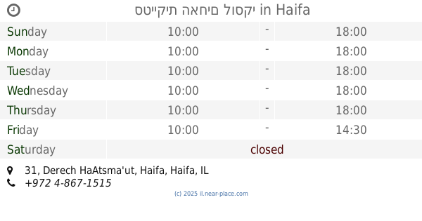
Ein ElWadi Restaurant
Derech HaAtsma'ut, Haifa, Haifa, IL Израиль
contacts phone
:
+972 4-855-3353
website:
www.facebook.com
Latitude:
32.8231404
, Longitude:
34.9934112
larger map & directions
read more
nearest Restaurant
277 m
לה בגט - אצל אלי
שדרות המגינים 79, חיפה
Restaurant
read more
363 m
מסעדת האם נבילה
תל אביב 1, חיפה
Restaurant
read more
454 m
Douzan
Sderot Ben Gurion 35, Haifa
Restaurant
read more
492 m
Joseph Bakery
HaBankim Street 10, Haifa
Restaurant
read more
493 m
Shtroudl
Sderot Ben Gurion 39, Haifa
Restaurant
read more
646 m
Hummus Al Sham
Wadi Street 21, Haifa
Restaurant
read more
688 m
Shipudei Ha’ir
Sderot HaMeginim 28, Haifa
Restaurant
read more
706 m
Shawarma Hazen
Jaffa Road 136, Haifa
Restaurant
read more
716 m
Shipudey Hair
נתנזון 2-6, חיפה
Restaurant
read more
757 m
מסעדת אבו יוסף
א.ל. זיסו 29, חיפה
Restaurant
read more
761 m
ג'קו מאכלי ים
קהילת סלוניקי 12, חיפה
Restaurant
read more
761 m
Jacko - Seafood Restaurant
Kehilat Saloniki Street 12, Haifa
Restaurant
read more
771 m
אדוארדוס
דרך העצמאות 37, חיפה
Restaurant
read more
792 m
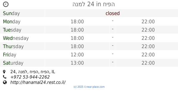
הנמל 24
הנמל 24, חיפה
Restaurant
read more
797 m
1 פלפל, 2 סוכר
Derech HaAtsma'ut 37, Haifa
Restaurant
read more
817 m
סטייקית האחים לוסקי
Derech HaAtsma'ut 31, Haifa
Restaurant
read more
840 m
פלאפל תימני
Natanzon Street 18, Haifa
Restaurant
read more
900 m
מסעדת אבו יוסף ובניו בעמ
שדרות הפלי"ם 1, חיפה
Restaurant
read more
900 m
Abu Yousef Restaurant & Sons Ltd.
Sderot HaPalyam 1, Haifa
Restaurant
read more
917 m
החומוס של גדי
Haifa
Restaurant
read more
985 m
לודנס אקספרס חיפה
Natanzon Street 22, Haifa
Restaurant
read more
990 m
Falafel
Ha-Nevi'im Street 2, Haifa
Restaurant
read more
994 m
לוקס
13, Ha-Namal Street, Haifa
Restaurant
read more
1.01 km
רוקו - Roku
הנמל 10, חיפה
Restaurant
read more
1.179 km
קבב שווארמה
העלייה השנייה 0, חיפה
Restaurant
read more
📑
all categories
Accounting
Administrative area level 1
Administrative area level 2
Airport
Amusement park
Aquarium
Art gallery
Atm
Bakery
Bank
Bar
Beauty salon
Bicycle store
Book store
Bowling alley
Bus station
Cafe
Campground
Car dealer
Car rental
Car repair
Car wash
Casino
Cemetery
Church
City hall
Clothing store
Colloquial area
Convenience store
Country
Courthouse
Dentist
Department store
Doctor
Electrician
Electronics store
Embassy
Establishment
Finance
Fire station
Florist
Food
Funeral home
Furniture store
Gas station
General contractor
Grocery or supermarket
Gym
Hair care
Hardware store
Health
Hindu Temple
Home goods store
Hospital
Insurance agency
Intersection
Jewelry store
Laundry
Lawyer
Library
Light rail station
Liquor store
Local government office
Locality
Locksmith
Lodging
Meal delivery
Meal takeaway
Mosque
Movie rental
Movie theater
Moving company
Museum
Natural feature
Neighborhood
Night club
Painter
Park
Parking
Pet store
Pharmacy
Physiotherapist
Place of worship
Plumber
Point of interest
Police
Political
Post office
Premise
Real estate agency
Restaurant
Roofing contractor
Route
Rv park, camping
School
Shoe store
Shopping mall
Spa
Stadium
Storage
Store
Subpremise
Subway station
Supermarket
Synagogue
Taxi stand
Train station
Transit station
Travel agency
University
Veterinary care
Zoo
administrative area level 3
administrative area level 4
sublocality level 1
↑