Restaurant nearby Abu Shukri
Coronavirus disease (COVID-19) Situation
confirmed cases
4841772
deaths
12707
Israel
Restaurant nearby Abu Shukri
Abu Shukri
Jerusalén
contacts phone
:
+972
Latitude:
31.7792786
, Longitude:
35.2306947
larger map & directions
read more
nearest Restaurant
179 m
Al-Sultan Restaurant
Suq Aftimos #7, Jerusalem Old City
Restaurant
read more
369 m
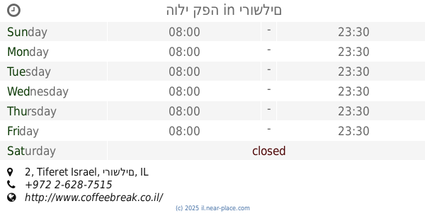
הולי קפה
Tiferet Israel 2, ירושלים
Restaurant
read more
398 m
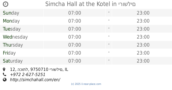
Simcha Hall at the Kotel
הכותל 12, ירושלים
Restaurant
read more
613 m
DIANA'S B & B
10 Hulda HaNeviah Street, Musrara, POB 4030, 91040 Jerusalem, Jerusalem
Restaurant
read more
682 m
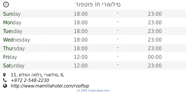
רופטופ
שלמה המלך 11, ירושלים
Restaurant
read more
703 m
מיאן נודלס
שלמה המלך 22, ירושלים
Restaurant
read more
785 m
Black Bar 'n' Burger
Queen Shlomziyon Street 18, Jerusalem
Restaurant
read more
788 m
Mangiare
Queen Shlomziyon Street 18, Jerusalem
Restaurant
read more
806 m
Walia Ibex
ירושלים
Restaurant
read more
844 m
Ben Sira Hummus
Ben Sira Street 3, Jerusalem
Restaurant
read more
853 m
JLM Local Sushi
10, King David, Jerusalem
Restaurant
read more
859 m
Rony's Pizza
Jaffa Street 25, Jerusalem
Restaurant
read more
860 m
אצה ירושלים
שלומציון המלכה 1, ירושלים
Restaurant
read more
916 m
גבריאל
שמעון בן שטח 7, ירושלים
Restaurant
read more
920 m
Grill Bar
Ha-Soreg Street 1, Jerusalem
Restaurant
read more
957 m
BBB
35, Hillel Street, Jerusalem
Restaurant
read more
970 m
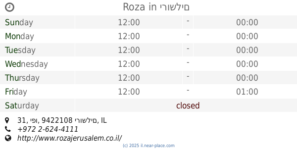
Roza
מתחם פיינגולד, יפו 31, ירושלים
Restaurant
read more
982 m
Sarwa Street Kitchen
Salah e-Din Street 42, Jerusalem
Restaurant
read more
983 m
גורמה Gourmet
Yosef Rivlin Street 18, Jerusalem
Restaurant
read more
1.009 km
Restaurante etio Israel
Yitskhak Elisar Street 6, Jerusalem
Restaurant
read more
1.022 km
שאנטי
מעלות נחלת שבעה 4, ירושלים
Restaurant
read more
1.067 km
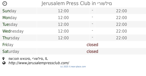
Jerusalem Press Club
משכנות שאננים, ירושלים
Restaurant
read more
1.122 km
Litov
הנביאים 43, ירושלים
Restaurant
read more
1.17 km
Deutch Restaurant
מאה שערים 50, ירושלים
Restaurant
read more
1.175 km
מסעדת דייטש
מאה שערים 32, ירושלים
Restaurant
read more
📑
all categories
Accounting
Administrative area level 1
Administrative area level 2
Airport
Amusement park
Aquarium
Art gallery
Atm
Bakery
Bank
Bar
Beauty salon
Bicycle store
Book store
Bowling alley
Bus station
Cafe
Campground
Car dealer
Car rental
Car repair
Car wash
Casino
Cemetery
Church
City hall
Clothing store
Colloquial area
Convenience store
Country
Courthouse
Dentist
Department store
Doctor
Electrician
Electronics store
Embassy
Establishment
Finance
Fire station
Florist
Food
Funeral home
Furniture store
Gas station
General contractor
Grocery or supermarket
Gym
Hair care
Hardware store
Health
Hindu Temple
Home goods store
Hospital
Insurance agency
Intersection
Jewelry store
Laundry
Lawyer
Library
Light rail station
Liquor store
Local government office
Locality
Locksmith
Lodging
Meal delivery
Meal takeaway
Mosque
Movie rental
Movie theater
Moving company
Museum
Natural feature
Neighborhood
Night club
Painter
Park
Parking
Pet store
Pharmacy
Physiotherapist
Place of worship
Plumber
Point of interest
Police
Political
Post office
Premise
Real estate agency
Restaurant
Roofing contractor
Route
Rv park, camping
School
Shoe store
Shopping mall
Spa
Stadium
Storage
Store
Subpremise
Subway station
Supermarket
Synagogue
Taxi stand
Train station
Transit station
Travel agency
University
Veterinary care
Zoo
administrative area level 3
administrative area level 4
sublocality level 1
↑