Place of worship nearby עיינות צוקים
Coronavirus disease (COVID-19) Situation
confirmed cases
4841772
deaths
12707
Israel
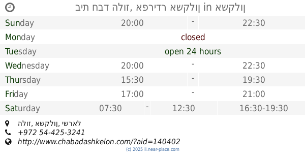
Place of worship nearby עיינות צוקים
עיינות צוקים
עינות צוקים, אשקלון, אשקלון, IL ישראל
contacts phone
:
+972
Latitude:
31.6505712
, Longitude:
34.5657857
larger map & directions
read more
nearest Place of worship
1.444 km
לשם נוי
שפירא 10, אשקלון
Place of worship
read more
1.444 km
לשם נוי
Shapira Street 10, Ashkelon
Place of worship
read more
1.533 km
Chez Nono
אשקלון
Place of worship
read more
1.849 km
Ашкелон Завод
15,, HaUman Street 13, Ashkelon
Place of worship
read more
2.861 km
Al majdal old mosque
Herzl Street 88, Ashkelon
Place of worship
read more
3.045 km
בית כנסת אהבת ציון (נוסח תימן - שאמי)
אשקלון
Place of worship
read more
3.045 km
בית כנסת "אהבת ציון" (נוסח תימן - שאמי)
Ashkelon
Place of worship
read more
3.148 km
בית חב"ד הלוז, אפרידר אשקלון
הלוז, Ashkelon
Place of worship
read more
3.148 km
בית חבד הלוז, אפרידר אשקלון
הלוז, אשקלון
Place of worship
read more
5.949 km
תפארת אפרים
3500, ברכיה
Place of worship
read more
5.949 km
תפארת אפרים
3500, Berekhya
Place of worship
read more
15.827 km
בית כנסת היכל יצחק
10, Mevo Yehu HaMelech 10, Ashdod
Place of worship
read more
16.28 km
Ati Thn - numerology, tarot and personal empowerment
Nahal Kidron Street 7, Ashdod
Place of worship
read more
16.28 km
אתי טחן - נומרולוגיה , טארוט והעצמה אישית
נחל קידרון 7, אשדוד
Place of worship
read more
16.977 km
אש דוד - מחניים
Yakinton Street 3, Ashdod
Place of worship
read more
17.981 km
בית הכנסת בית יצחק אוהל אליהו
Ha-Shayatim Street 12, Ashdod
Place of worship
read more
17.981 km
בית הכנסת בית יצחק אוהל אליהו
השייטים 12, אשדוד
Place of worship
read more
18.78 km
Meeting of Ukmerge
Sha'arei Yosher Street, Ashdod
Place of worship
read more
19.039 km
למען שמו באהבה הרב מויאל
Ha-Gvura Street 9, Kiryat Gat
Place of worship
read more
19.963 km
مسجد الفاروق
الزيتون شارع بيارة ابو شعبان
Place of worship
read more
20.195 km
مسجد شهداء الزيتون
Al Shareaa Al Gadid, El-Zaytoun
Place of worship
read more
22.451 km
Adama México
Ha-Ashlag Street 1, Ashdod
Place of worship
read more
29.42 km
The Great Synagogue
Harimon Street 102, Beit Gamliel
Place of worship
read more
29.42 km
בית כנסת הגדול
הרימון 102, בית גמליאל
Place of worship
read more
33.067 km
בית כנסת גבעת ברנר
Tainer Street, Givat Brenner
Place of worship
read more
📑
all categories
Accounting
Administrative area level 1
Administrative area level 2
Airport
Amusement park
Aquarium
Art gallery
Atm
Bakery
Bank
Bar
Beauty salon
Bicycle store
Book store
Bowling alley
Bus station
Cafe
Campground
Car dealer
Car rental
Car repair
Car wash
Casino
Cemetery
Church
City hall
Clothing store
Colloquial area
Convenience store
Country
Courthouse
Dentist
Department store
Doctor
Electrician
Electronics store
Embassy
Establishment
Finance
Fire station
Florist
Food
Funeral home
Furniture store
Gas station
General contractor
Grocery or supermarket
Gym
Hair care
Hardware store
Health
Hindu Temple
Home goods store
Hospital
Insurance agency
Intersection
Jewelry store
Laundry
Lawyer
Library
Light rail station
Liquor store
Local government office
Locality
Locksmith
Lodging
Meal delivery
Meal takeaway
Mosque
Movie rental
Movie theater
Moving company
Museum
Natural feature
Neighborhood
Night club
Painter
Park
Parking
Pet store
Pharmacy
Physiotherapist
Place of worship
Plumber
Point of interest
Police
Political
Post office
Premise
Real estate agency
Restaurant
Roofing contractor
Route
Rv park, camping
School
Shoe store
Shopping mall
Spa
Stadium
Storage
Store
Subpremise
Subway station
Supermarket
Synagogue
Taxi stand
Train station
Transit station
Travel agency
University
Veterinary care
Zoo
administrative area level 3
administrative area level 4
sublocality level 1
↑