Pharmacy nearby סופר פארם
Israel
Pharmacy nearby סופר פארם
סופר פארם
רח' רפפורט 19, Kefar Sava, ישראל
contacts phone
:
+972 77-888-2250
website:
www.super-pharm.co.il
Latitude:
32.1924426
, Longitude:
34.8919955
larger map & directions
read more
nearest Pharmacy
81 m
סופר-פארם כפר סבא הירוקה
רח' רפפורט 19, כפר סבא
Pharmacy
read more
81 m
Супер-Фарм
רח' רפפורט 19, כפר סבא
Pharmacy
read more
656 m
ניו פארם
אנגל 78, כפר סבא
Pharmacy
read more
656 m
New Pharm
Engel Street 78, Kefar Sava
Pharmacy
read more
1.269 km
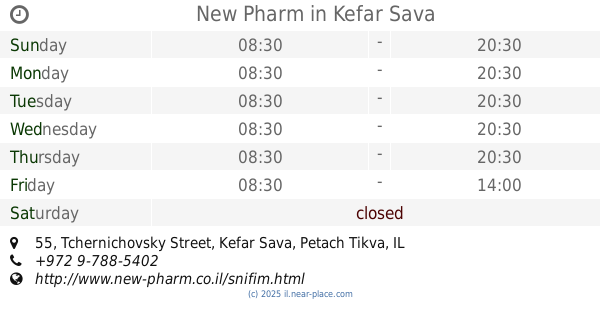
ניו פארם
Tchernichovsky Street 55, Kefar Sava
Pharmacy
read more
1.269 km
New Pharm
Tchernichovsky Street 55, Kefar Sava
Pharmacy
read more
1.346 km
כללית - בית מרקחת
טשרניחובסקי 59, כפר סבא
Pharmacy
read more
1.406 km
סופר-פארם קניון רננים
קניון רננים, המלאכה 2, רעננה
Pharmacy
read more
1.406 km
Супер-Фарм
קניון רננים, המלאכה 2, רעננה
Pharmacy
read more
1.406 km
Super-Pharm
קניון רננים, המלאכה 2, רעננה
Pharmacy
read more
1.697 km
מדיקסטור
כפר סבא
Pharmacy
read more
1.699 km
בית מרקחת מדיקסטור
טשרניחובסקי 24, כפר סבא
Pharmacy
read more
1.699 km
בית מרקחת מדיקסטור
Tchernichovsky Street 24, Kefar Sava
Pharmacy
read more
1.873 km
גלעד כפר סבא
כפר סבא
Pharmacy
read more
1.922 km
Super-Pharm
Ahuza Street 83, Ra'anana
Pharmacy
read more
1.922 km
Супер-Фарм
Ahuza Street 83, Ra'anana
Pharmacy
read more
1.928 km
Поликлиника Клалит
ברל כצנסלון 14, קניון ערים, Kefar Sava
Pharmacy
read more
2.032 km
סופר-פארם קניון ערים כפר סבא
ויצמן 63, כפר סבא
Pharmacy
read more
2.032 km
Супер-Фарм
Weizmann Street 63, Kefar Sava
Pharmacy
read more
2.109 km
דר' סמואלוב
אחוזה 120, רעננה
Pharmacy
read more
2.257 km
Супер-Фарм
Weizmann Street 78, Kefar Sava
Pharmacy
read more
2.453 km
Maccabi Kfar Saba
Rothschild Street 56, Kefar Sava
Pharmacy
read more
2.526 km
Arza
Ostrovsky Street, Ra'anana
Pharmacy
read more
2.551 km
בית מרקחת כנרת
ויצמן 119, כפר סבא
Pharmacy
read more
2.551 km
בית מרקחת כנרת
Weizmann Street 119, Kefar Sava
Pharmacy
read more
📑
all categories
Accounting
Administrative area level 1
Administrative area level 2
Airport
Amusement park
Aquarium
Art gallery
Atm
Bakery
Bank
Bar
Beauty salon
Bicycle store
Book store
Bowling alley
Bus station
Cafe
Campground
Car dealer
Car rental
Car repair
Car wash
Casino
Cemetery
Church
City hall
Clothing store
Colloquial area
Convenience store
Country
Courthouse
Dentist
Department store
Doctor
Electrician
Electronics store
Embassy
Establishment
Finance
Fire station
Florist
Food
Funeral home
Furniture store
Gas station
General contractor
Grocery or supermarket
Gym
Hair care
Hardware store
Health
Hindu Temple
Home goods store
Hospital
Insurance agency
Intersection
Jewelry store
Laundry
Lawyer
Library
Light rail station
Liquor store
Local government office
Locality
Locksmith
Lodging
Meal delivery
Meal takeaway
Mosque
Movie rental
Movie theater
Moving company
Museum
Natural feature
Neighborhood
Night club
Painter
Park
Parking
Pet store
Pharmacy
Physiotherapist
Place of worship
Plumber
Point of interest
Police
Political
Post office
Premise
Real estate agency
Restaurant
Roofing contractor
Route
Rv park, camping
School
Shoe store
Shopping mall
Spa
Stadium
Storage
Store
Subpremise
Subway station
Supermarket
Synagogue
Taxi stand
Train station
Transit station
Travel agency
University
Veterinary care
Zoo
administrative area level 3
administrative area level 4
sublocality level 1
↑