Pharmacy nearby Super-Pharm
Coronavirus disease (COVID-19) Situation
confirmed cases
4841772
deaths
12707
Israel
Pharmacy nearby Super-Pharm
Super-Pharm
51, Sderot Yerushalayim, Kiryat Yam, Haifa, IL Israel
contacts phone
:
+972 77-888-1560
website:
www.super-pharm.co.il
Latitude:
32.8430816
, Longitude:
35.0693358
larger map & directions
read more
nearest Pharmacy
427 m
קופת חולים לאומית. קרית ים
יצחק בן צבי 49, קרית ים
Pharmacy
read more
427 m
קופת חולים לאומית. קרית ים
Yitshak Ben Zvi Street 49, Kiryat Yam
Pharmacy
read more
445 m
Medica Kiryat Yam
Kiryat Yam
Pharmacy
read more
483 m
כללית - בית מרקחת
אלי כהן 29, קרית ים
Pharmacy
read more
483 m
Clalit Pharmacy
Eli Cohen Street 29, Kiryat Yam
Pharmacy
read more
561 m
Clalit Pharmacy
Sderot Herbert Liehman 19, Kiryat Yam
Pharmacy
read more
621 m
מרכז מנחם
קרית ים
Pharmacy
read more
621 m
Menachem Center
Kiryat Yam
Pharmacy
read more
949 m
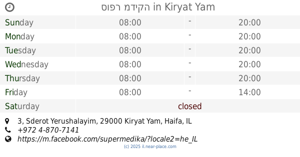
סופר מדיקה
Sderot Yerushalayim 3, Kiryat Yam
Pharmacy
read more
1.13 km
פנטגון
קרית מוצקין
Pharmacy
read more
1.13 km
Pentagon
Kiryat Motzkin
Pharmacy
read more
1.164 km
New Farm Motzkin
Kiryat Motzkin
Pharmacy
read more
1.19 km
כללית - בית מרקחת
הרב קוק 104, קרית מוצקין
Pharmacy
read more
1.296 km
קופת חולים כללית
Modi'in Street 2-16, Kiryat Yam
Pharmacy
read more
1.296 km
קופת חולים כללית
מודיעין 2-16, קרית ים
Pharmacy
read more
1.343 km
כללית בית מרקחת
הנגב 4, קרית ים
Pharmacy
read more
1.442 km
Поликлиника Клалит
Shvil Modi'in 4, Kiryat Motzkin
Pharmacy
read more
1.442 km
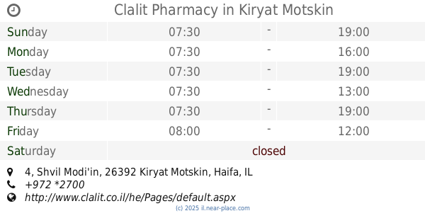
Clalit Pharmacy
Shvil Modi'in 4, Kiryat Motzkin
Pharmacy
read more
1.615 km
Maccabi Galron
נתניהו יונתן 8, קרית מוצקין
Pharmacy
read more
1.615 km
מרפאת מכבי, גלרון, קריית מוצקין
נתניהו יונתן 8, קרית מוצקין
Pharmacy
read more
1.663 km
בית מרקחת
Kiryat Bialik
Pharmacy
read more
1.711 km
Clalit Pharmacy
Abarbanel Street 35, Haifa
Pharmacy
read more
1.711 km
כללית בית מרקחת
אברבנאל 35, חיפה
Pharmacy
read more
1.968 km
בית מרקחת היסוד
Keren ha-Yesod Street 73, Kiryat Bialik
Pharmacy
read more
2.124 km
Sabinya
Kiryat Bialik
Pharmacy
read more
📑
all categories
Accounting
Administrative area level 1
Administrative area level 2
Airport
Amusement park
Aquarium
Art gallery
Atm
Bakery
Bank
Bar
Beauty salon
Bicycle store
Book store
Bowling alley
Bus station
Cafe
Campground
Car dealer
Car rental
Car repair
Car wash
Casino
Cemetery
Church
City hall
Clothing store
Colloquial area
Convenience store
Country
Courthouse
Dentist
Department store
Doctor
Electrician
Electronics store
Embassy
Establishment
Finance
Fire station
Florist
Food
Funeral home
Furniture store
Gas station
General contractor
Grocery or supermarket
Gym
Hair care
Hardware store
Health
Hindu Temple
Home goods store
Hospital
Insurance agency
Intersection
Jewelry store
Laundry
Lawyer
Library
Light rail station
Liquor store
Local government office
Locality
Locksmith
Lodging
Meal delivery
Meal takeaway
Mosque
Movie rental
Movie theater
Moving company
Museum
Natural feature
Neighborhood
Night club
Painter
Park
Parking
Pet store
Pharmacy
Physiotherapist
Place of worship
Plumber
Point of interest
Police
Political
Post office
Premise
Real estate agency
Restaurant
Roofing contractor
Route
Rv park, camping
School
Shoe store
Shopping mall
Spa
Stadium
Storage
Store
Subpremise
Subway station
Supermarket
Synagogue
Taxi stand
Train station
Transit station
Travel agency
University
Veterinary care
Zoo
administrative area level 3
administrative area level 4
sublocality level 1
↑