Pharmacy nearby ספוואן
Israel
Pharmacy nearby ספוואן
ספוואן
שפרעם, ישראל
contacts phone
:
+972
Latitude:
32.811138
, Longitude:
35.163004
larger map & directions
read more
nearest Pharmacy
17 m
al'Ayn
Kamal Junbalat Street, Shefa-'Amr
Pharmacy
read more
17 m
אלעין - בית מרקחת
כמאל ג'ונבלאט, שפרעם
Pharmacy
read more
192 m
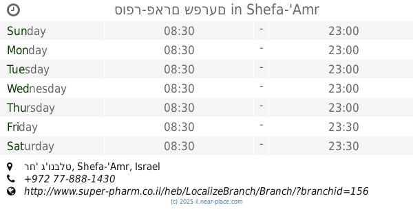
סופר-פארם שפרעם
רח' ג'ונבלט, Shefa-'Amr
Pharmacy
read more
1.034 km
صيدلية الرازي
شارع خارت ألسك،, Shefa-'Amr
Pharmacy
read more
1.231 km
Central Pharm
Shefa-'Amr
Pharmacy
read more
1.332 km
מרכז שפרעם ארמלי
שפרעם
Pharmacy
read more
1.388 km
דרגסטור
Tawfiq Ziad Street, Shefa-'Amr
Pharmacy
read more
1.411 km
בית מרקחת אל שיפא שפרעם
רחוב חסן נימר 20200, שפרעם
Pharmacy
read more
1.411 km
Al Shifa Pharmacy Shfar'am
Hasan Nimaer Street 20200, Shefa-'Amr
Pharmacy
read more
1.454 km
כללית - בית מרקחת
שפרעם, דואר שפרעם, שפרעם
Pharmacy
read more
2.018 km
אבן סינא שפרעם
שפרעם
Pharmacy
read more
2.797 km
כללית בית מרקחת
אעבלין-בניין המועצה, בניין המועצה, אעבלין
Pharmacy
read more
2.797 km
Поликлиника Клалит
אעבלין-בניין המועצה, בניין המועצה, I'billin
Pharmacy
read more
2.899 km
סטאר פארמד , בית מרקחת אעבלין , אדיב נג'מי
רח ראשי 201,סנטר נג'מי I'billin, I'billin
Pharmacy
read more
2.955 km
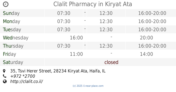
כללית - בית מרקחת
צבי הרר 35, קרית אתא
Pharmacy
read more
2.955 km
כללית - בית מרקחת
Tsvi Herer Street 35, Kiryat Ata
Pharmacy
read more
3.019 km
Clalit Pharmacy
Tsvi Herer Street 35, Kiryat Ata
Pharmacy
read more
3.474 km
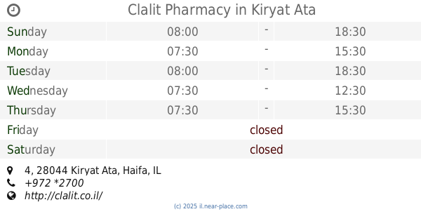
Clalit Pharmacy
4, Kiryat Ata
Pharmacy
read more
4.238 km
כללית בית מרקחת
הרב עוזיאל 22, קרית אתא
Pharmacy
read more
4.238 km
Поликлиника Клалит
Ha-Rav Uzi'el Street 22, Kiryat Ata
Pharmacy
read more
4.425 km
בית מרקחת שביט בעמ
Einstein Street 20, Kiryat Ata
Pharmacy
read more
4.434 km
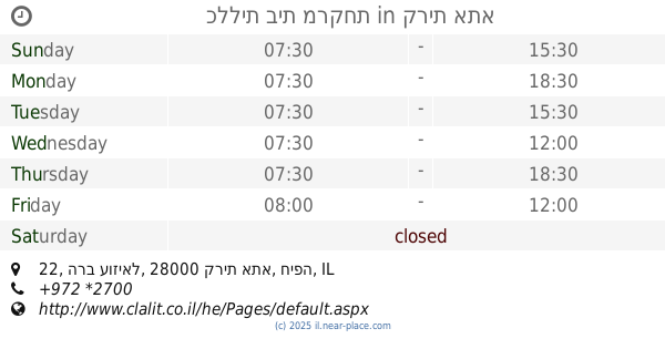
אנסקה
קרית אתא
Pharmacy
read more
4.463 km
זיו פארם
קרית אתא
Pharmacy
read more
5.561 km
טמרה פארם
ראשי, טמרה
Pharmacy
read more
5.612 km
Pharmacy Center
Tamra
Pharmacy
read more
📑
all categories
Accounting
Administrative area level 1
Administrative area level 2
Airport
Amusement park
Aquarium
Art gallery
Atm
Bakery
Bank
Bar
Beauty salon
Bicycle store
Book store
Bowling alley
Bus station
Cafe
Campground
Car dealer
Car rental
Car repair
Car wash
Casino
Cemetery
Church
City hall
Clothing store
Colloquial area
Convenience store
Country
Courthouse
Dentist
Department store
Doctor
Electrician
Electronics store
Embassy
Establishment
Finance
Fire station
Florist
Food
Funeral home
Furniture store
Gas station
General contractor
Grocery or supermarket
Gym
Hair care
Hardware store
Health
Hindu Temple
Home goods store
Hospital
Insurance agency
Intersection
Jewelry store
Laundry
Lawyer
Library
Light rail station
Liquor store
Local government office
Locality
Locksmith
Lodging
Meal delivery
Meal takeaway
Mosque
Movie rental
Movie theater
Moving company
Museum
Natural feature
Neighborhood
Night club
Painter
Park
Parking
Pet store
Pharmacy
Physiotherapist
Place of worship
Plumber
Point of interest
Police
Political
Post office
Premise
Real estate agency
Restaurant
Roofing contractor
Route
Rv park, camping
School
Shoe store
Shopping mall
Spa
Stadium
Storage
Store
Subpremise
Subway station
Supermarket
Synagogue
Taxi stand
Train station
Transit station
Travel agency
University
Veterinary care
Zoo
administrative area level 3
administrative area level 4
sublocality level 1
↑