Pharmacy nearby Sanitas Lod
Israel
Pharmacy nearby Sanitas Lod
Sanitas Lod
Lod, Israel
contacts phone
:
+972
Latitude:
31.9568238
, Longitude:
34.8968529
larger map & directions
read more
nearest Pharmacy
סניטס לוד
לוד
Pharmacy
read more
67 m
בית מרקחת לאומית
Lod
Pharmacy
read more
997 m
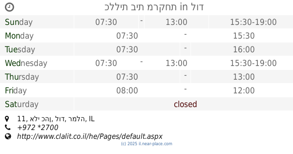
Поликлиника Клалит
Eli Cohen Street 11, Lod
Pharmacy
read more
997 m
Clalit Pharmacy
Eli Cohen Street 11, Lod
Pharmacy
read more
997 m
כללית בית מרקחת
אלי כהן 11, לוד
Pharmacy
read more
1.05 km
Mazor Lod
Lod
Pharmacy
read more
1.164 km
Супер-Фарм
שד' דוד המלך 2, לוד
Pharmacy
read more
1.164 km
Super-Pharm
שד' דוד המלך 2, לוד
Pharmacy
read more
1.282 km
כללית בית מרקחת
שדרות הציונות 1, לוד
Pharmacy
read more
1.282 km
Clalit Pharmacy
Sderot Hatsiyonut 1, Lod
Pharmacy
read more
1.282 km
Поликлиника Клалит
Sderot Hatsiyonut 1, Lod
Pharmacy
read more
1.328 km
Maccabi Merkazi Lod
Lod
Pharmacy
read more
1.328 km
מכבי מרכזי לוד
לוד
Pharmacy
read more
1.603 km
פארמה סטייל
ארבע העונות 14, לוד
Pharmacy
read more
1.603 km
פארמה סטייל
ארבע העונות 14, Lod
Pharmacy
read more
1.735 km
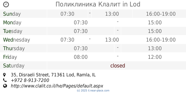
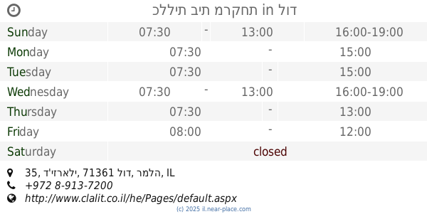
Поликлиника Клалит
Disraeli Street 35, Lod
Pharmacy
read more
1.735 km
כללית בית מרקחת
ד'יזראלי 35, לוד
Pharmacy
read more
1.771 km
Ahisemech project Schechter
Lod
Pharmacy
read more
2.742 km
סופר-פארם רמלוד
Tsofit Street 40, Ramla
Pharmacy
read more
2.743 km
סופר פארם
רמלה
Pharmacy
read more
2.743 km
Супер-Фарм
Ramla
Pharmacy
read more
2.92 km
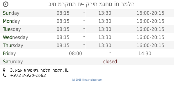
בית מרקחת חי- קרית מנחם
אבא אחימאיר 3, רמלה
Pharmacy
read more
2.92 km
Hai Kiryat Menachem
Abba Ahimeir Street 3, Ramla
Pharmacy
read more
5.983 km
Meuhedet
הרבי מליובאוויטש 4, Kfar Habad
Pharmacy
read more
5.983 km
מאוחדת פארם כפר חבד
הרבי מליובאוויטש 4, כפר חב"ד
Pharmacy
read more
📑
all categories
Accounting
Administrative area level 1
Administrative area level 2
Airport
Amusement park
Aquarium
Art gallery
Atm
Bakery
Bank
Bar
Beauty salon
Bicycle store
Book store
Bowling alley
Bus station
Cafe
Campground
Car dealer
Car rental
Car repair
Car wash
Casino
Cemetery
Church
City hall
Clothing store
Colloquial area
Convenience store
Country
Courthouse
Dentist
Department store
Doctor
Electrician
Electronics store
Embassy
Establishment
Finance
Fire station
Florist
Food
Funeral home
Furniture store
Gas station
General contractor
Grocery or supermarket
Gym
Hair care
Hardware store
Health
Hindu Temple
Home goods store
Hospital
Insurance agency
Intersection
Jewelry store
Laundry
Lawyer
Library
Light rail station
Liquor store
Local government office
Locality
Locksmith
Lodging
Meal delivery
Meal takeaway
Mosque
Movie rental
Movie theater
Moving company
Museum
Natural feature
Neighborhood
Night club
Painter
Park
Parking
Pet store
Pharmacy
Physiotherapist
Place of worship
Plumber
Point of interest
Police
Political
Post office
Premise
Real estate agency
Restaurant
Roofing contractor
Route
Rv park, camping
School
Shoe store
Shopping mall
Spa
Stadium
Storage
Store
Subpremise
Subway station
Supermarket
Synagogue
Taxi stand
Train station
Transit station
Travel agency
University
Veterinary care
Zoo
administrative area level 3
administrative area level 4
sublocality level 1
↑