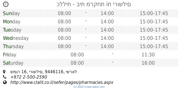
Pharmacy nearby Ramat Eshkol Pharmacy
Israel
Pharmacy nearby Ramat Eshkol Pharmacy
Ramat Eshkol Pharmacy
15, פארן, ירושלים
contacts phone
:
+972
Latitude:
31.8008555
, Longitude:
35.2270814
larger map & directions
read more
nearest Pharmacy
66 m
כללית בית מרקחת
פארן 12, ירושלים
Pharmacy
read more
880 m
ramat shlomo pharm ltd
Hazon Ish Street 36, Jerusalem
Pharmacy
read more
883 m
בית מרקחת רמת שלמה
חזון איש 36, Jerusalem
Pharmacy
read more
906 m
Clalit Pharmacy
Golda Me'ir Boulevard 25, Jerusalem
Pharmacy
read more
906 m
כללית בית מרקחת
שדרות גולדה מאיר 25, ירושלים
Pharmacy
read more
911 m
Medi Plus
Bar Ilan 2, Jerusalem
Pharmacy
read more
917 m
כללית בית מרקחת
בר אילן 2, ירושלים
Pharmacy
read more
917 m
Clalit Pharmacy
Bar Ilan 2, Jerusalem
Pharmacy
read more
917 m
Поликлиника Клалит
Bar Ilan 2, Jerusalem
Pharmacy
read more
1.246 km
מקסי פארם ברוכים גוש 80
חכם שמואל ברוכים 9, ירושלים
Pharmacy
read more
1.341 km
Поликлиника Клалит
Ha-Rav Arye Goldknopf Street, Jerusalem
Pharmacy
read more
1.341 km
קופת חולים כללית
Ha-Rav Arye Goldknopf Street, Jerusalem
Pharmacy
read more
1.341 km
Clalit
Ha-Rav Arye Goldknopf Street, Jerusalem
Pharmacy
read more
1.794 km
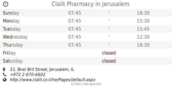
Clalit Pharmacy
Bnei Brit Street 22, Jerusalem
Pharmacy
read more
1.861 km
Поликлиника Клалит
Me'a She'arim Street 83, Jerusalem
Pharmacy
read more
1.861 km
Clalit Pharmacy
Me'a She'arim Street 83, Jerusalem
Pharmacy
read more
1.866 km
صيدلية الساهرة
אל אספהאני, ירושלים
Pharmacy
read more
1.891 km
כללית - בית מרקחת
שמגר 16, ירושלים
Pharmacy
read more
1.907 km
Sigma-Aldrich-Merck
Kiryat HaMada Street 15, Jerusalem
Pharmacy
read more
1.942 km
Batish Madisayev
Jerusalem
Pharmacy
read more
1.942 km
בטיש מדיסייב
ירושלים
Pharmacy
read more
1.977 km
Rina Pharm
David Yellin Street 31, Jerusalem
Pharmacy
read more
2.063 km
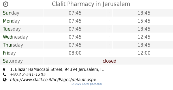
Поликлиника Клалит
Elazar HaMaccabi Street 1, Jerusalem
Pharmacy
read more
2.063 km
Clalit Pharmacy
Elazar HaMaccabi Street 1, Jerusalem
Pharmacy
read more
2.154 km
מני
ירושלים
Pharmacy
read more
📑
all categories
Accounting
Administrative area level 1
Administrative area level 2
Airport
Amusement park
Aquarium
Art gallery
Atm
Bakery
Bank
Bar
Beauty salon
Bicycle store
Book store
Bowling alley
Bus station
Cafe
Campground
Car dealer
Car rental
Car repair
Car wash
Casino
Cemetery
Church
City hall
Clothing store
Colloquial area
Convenience store
Country
Courthouse
Dentist
Department store
Doctor
Electrician
Electronics store
Embassy
Establishment
Finance
Fire station
Florist
Food
Funeral home
Furniture store
Gas station
General contractor
Grocery or supermarket
Gym
Hair care
Hardware store
Health
Hindu Temple
Home goods store
Hospital
Insurance agency
Intersection
Jewelry store
Laundry
Lawyer
Library
Light rail station
Liquor store
Local government office
Locality
Locksmith
Lodging
Meal delivery
Meal takeaway
Mosque
Movie rental
Movie theater
Moving company
Museum
Natural feature
Neighborhood
Night club
Painter
Park
Parking
Pet store
Pharmacy
Physiotherapist
Place of worship
Plumber
Point of interest
Police
Political
Post office
Premise
Real estate agency
Restaurant
Roofing contractor
Route
Rv park, camping
School
Shoe store
Shopping mall
Spa
Stadium
Storage
Store
Subpremise
Subway station
Supermarket
Synagogue
Taxi stand
Train station
Transit station
Travel agency
University
Veterinary care
Zoo
administrative area level 3
administrative area level 4
sublocality level 1
↑