Parking nearby Parking lot The Moat - the walls of Acre
Coronavirus disease (COVID-19) Situation
confirmed cases
4841772
deaths
12707
Israel
Parking nearby Parking lot The Moat - the walls of Acre
Parking lot The Moat - the walls of Acre
2, 4, חיפה, עכו, IL Israel
contacts phone
:
+972
Latitude:
32.9219917
, Longitude:
35.0734444
larger map & directions
read more
nearest Parking
67 m
חניון החפיר
עכו
Parking
read more
185 m
HaAbirim Parking Lot
Acre
Parking
read more
196 m
חניון עכו העתיקה
El Jzzar St 1, Acre
Parking
read more
196 m
חניון עכו העתיקה
Salah ad Din Street, Acre
Parking
read more
384 m
חניון האקליפטוסים
David Pinkas Street, Acre
Parking
read more
698 m
Acre's Lighthouse
Acre
Parking
read more
698 m
Acre's Lighthouse
עכו
Parking
read more
698 m
Акрс Лайтхаус
Acre
Parking
read more
698 m
HaMigdalor Parking Lot
Acre
Parking
read more
863 m
תחנה מרכזית אגד
עכו
Parking
read more
863 m
Egged Central Bus Station
Акко
Parking
read more
1.766 km
Trucks position
Acre
Parking
read more
8.579 km
חניון חי פארק קרית מוצקין
קרית מוצקין
Parking
read more
9.761 km
AS prod
Herev La'et Street, חרב לאת
Parking
read more
12.025 km
Egged Terminal
Хайфа
Parking
read more
13.333 km
Parking lot
Kdoshei Bagdad Street, Haifa
Parking
read more
13.606 km
Дом Стоянка
Akhva Street 19, Haifa
Parking
read more
13.626 km
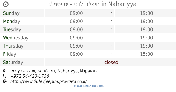
ג'יפסי סי - טיולי ג'יפים
קיבוץ גשר הזיו, ישראל ליד, Nahariyya
Parking
read more
13.826 km
Parking Haifa
Gottlieb Schumacher Street 1-17, Haifa
Parking
read more
13.856 km
Khuri 2 Parking
Ma'alot HaNevi'im St 23, Tel Aviv-Yafo
Parking
read more
14.087 km
Стоянка
יחיאל 21-23, חיפה
Parking
read more
14.558 km
חניון גבעת המשורין
Israel
Parking
read more
14.601 km
חניון עליון ליאו בק
אדמונד פלג 20, חיפה
Parking
read more
15.759 km
The Pines Day Stop
Sderot HaBroshim 1, Haifa
Parking
read more
17.463 km
חניון
Haifa
Parking
read more
📑
all categories
Accounting
Administrative area level 1
Administrative area level 2
Airport
Amusement park
Aquarium
Art gallery
Atm
Bakery
Bank
Bar
Beauty salon
Bicycle store
Book store
Bowling alley
Bus station
Cafe
Campground
Car dealer
Car rental
Car repair
Car wash
Casino
Cemetery
Church
City hall
Clothing store
Colloquial area
Convenience store
Country
Courthouse
Dentist
Department store
Doctor
Electrician
Electronics store
Embassy
Establishment
Finance
Fire station
Florist
Food
Funeral home
Furniture store
Gas station
General contractor
Grocery or supermarket
Gym
Hair care
Hardware store
Health
Hindu Temple
Home goods store
Hospital
Insurance agency
Intersection
Jewelry store
Laundry
Lawyer
Library
Light rail station
Liquor store
Local government office
Locality
Locksmith
Lodging
Meal delivery
Meal takeaway
Mosque
Movie rental
Movie theater
Moving company
Museum
Natural feature
Neighborhood
Night club
Painter
Park
Parking
Pet store
Pharmacy
Physiotherapist
Place of worship
Plumber
Point of interest
Police
Political
Post office
Premise
Real estate agency
Restaurant
Roofing contractor
Route
Rv park, camping
School
Shoe store
Shopping mall
Spa
Stadium
Storage
Store
Subpremise
Subway station
Supermarket
Synagogue
Taxi stand
Train station
Transit station
Travel agency
University
Veterinary care
Zoo
administrative area level 3
administrative area level 4
sublocality level 1
↑