Parking nearby חניון הילה
Israel
Parking nearby חניון הילה
חניון הילה
ישראל
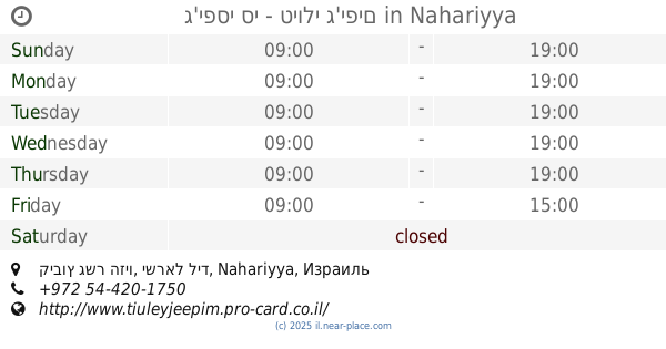
contacts phone
:
+972
Latitude:
33.033067
, Longitude:
35.238992
larger map & directions
read more
nearest Parking
2.413 km
Goren Park Monfort Fortress Parking
Israel
Parking
read more
3.736 km
Attitude Valley Harikh
Israel
Parking
read more
3.736 km
חניון נחל שרך
Israel
Parking
read more
5.881 km
חניון גבעת המשורין
Israel
Parking
read more
5.992 km
Monfort Lake Parking
Israel
Parking
read more
6.222 km
Keshet Cave parking
Israel
Parking
read more
6.39 km
حرش أدميت
Israel
Parking
read more
6.412 km
גבעת המשוריין
Israel
Parking
read more
6.468 km
חנייה ישקר ראשית
Israel
Parking
read more
8.159 km
חניון פסגות הגליל
כיסרא סומיע
Parking
read more
8.243 km
Position Lapidot
Israel
Parking
read more
9.262 km
Shlomi Parking Lot
Shlomi
Parking
read more
11.999 km
ג'יפסי סי - טיולי ג'יפים
קיבוץ גשר הזיו, ישראל ליד, Nahariyya
Parking
read more
12.515 km
Parking Lot for a short time
התמר 25, לימן
Parking
read more
12.515 km
Parking Lot for a short time
Ha-Tamar Street 25, Liman
Parking
read more
12.578 km
חניוני חורשת בצת
Israel
Parking
read more
12.73 km
Akhziv Parking
Israel
Parking
read more
13.43 km
Park and Go
Karmiel
Parking
read more
13.43 km
חנה וסע
כרמיאל
Parking
read more
13.5 km
חניון וולפסון
נהריה
Parking
read more
13.965 km
חניון לב העיר
וייצמן 64, נהריה
Parking
read more
13.97 km
חניון תת קרקעי
הגליל 6, כרמיאל
Parking
read more
13.97 km
חניון תת קרקעי
HaGalil Street 6, Karmiel
Parking
read more
14.939 km
פארק גלגליות
Karmiel
Parking
read more
18.909 km
תחנה מרכזית אגד
עכו
Parking
read more
📑
all categories
Accounting
Administrative area level 1
Administrative area level 2
Airport
Amusement park
Aquarium
Art gallery
Atm
Bakery
Bank
Bar
Beauty salon
Bicycle store
Book store
Bowling alley
Bus station
Cafe
Campground
Car dealer
Car rental
Car repair
Car wash
Casino
Cemetery
Church
City hall
Clothing store
Colloquial area
Convenience store
Country
Courthouse
Dentist
Department store
Doctor
Electrician
Electronics store
Embassy
Establishment
Finance
Fire station
Florist
Food
Funeral home
Furniture store
Gas station
General contractor
Grocery or supermarket
Gym
Hair care
Hardware store
Health
Hindu Temple
Home goods store
Hospital
Insurance agency
Intersection
Jewelry store
Laundry
Lawyer
Library
Light rail station
Liquor store
Local government office
Locality
Locksmith
Lodging
Meal delivery
Meal takeaway
Mosque
Movie rental
Movie theater
Moving company
Museum
Natural feature
Neighborhood
Night club
Painter
Park
Parking
Pet store
Pharmacy
Physiotherapist
Place of worship
Plumber
Point of interest
Police
Political
Post office
Premise
Real estate agency
Restaurant
Roofing contractor
Route
Rv park, camping
School
Shoe store
Shopping mall
Spa
Stadium
Storage
Store
Subpremise
Subway station
Supermarket
Synagogue
Taxi stand
Train station
Transit station
Travel agency
University
Veterinary care
Zoo
administrative area level 3
administrative area level 4
sublocality level 1
↑