Parking nearby המערכה
Coronavirus disease (COVID-19) Situation
confirmed cases
4841772
deaths
12707
Israel
Parking nearby המערכה
המערכה
תל אביב יפו, ישראל
contacts phone
:
+972
Latitude:
32.061427
, Longitude:
34.793134
larger map & directions
read more
nearest Parking
161 m
Palmakh
Tel Aviv-Yafo
Parking
read more
177 m
68 Yigal Alon St Parking
68 Yigal Alon St, Tel Aviv-Yafo
Parking
read more
423 m
Yitshak Sadeh St 43 Parking
Yitshak Sadeh St 43, Tel Aviv-Yafo
Parking
read more
487 m
חניון היכלי הספורט תל אביב - היכל מנורה מבטחים יד אליהו
Ha-Shlosha Street 2, Tel Aviv-Yafo
Parking
read more
503 m
חניון מגדלי טויוטה בית חולים אסותא והיכל נוקיה תל אביב
יגאל אלון 67, תל אביב יפו
Parking
read more
588 m
אהרון חניונים
Tel Aviv-Yafo
Parking
read more
588 m
אהרון חניונים
תל אביב יפו
Parking
read more
605 m
רבניצקי
תל אביב יפו
Parking
read more
807 m
Ha-Solelim parking
Tel Aviv-Yafo
Parking
read more
910 m
חניון סנטרל פארק - המלאכה
המלאכה 4, תל אביב יפו
Parking
read more
910 m
חניון סנטרל פארק - המלאכה
HaMelacha Street 4, Tel Aviv-Yafo
Parking
read more
920 m
חניה חניון גדול
11,, Doctor Tcherna Street 1, Tel Aviv-Yafo
Parking
read more
972 m
ליאו גולדברג Parking
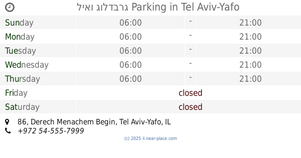
דרך מנחם בגין 86, תל אביב יפו
Parking
read more
972 m
ליאו גולדברג Parking
Derech Menachem Begin 86, Tel Aviv-Yafo
Parking
read more
976 m
חניה
Vatik Street 11, Tel Aviv-Yafo
Parking
read more
989 m
חניון מגדל אמפא - אסותא השלום, תל אביב
Tuval Street 4, Tel Aviv-Yafo
Parking
read more
990 m
חניון אמפא TLV
Tuval Street 4, Tel Aviv-Yafo
Parking
read more
1.014 km
תל-אופן
שדרות יהודית 9, תל אביב יפו
Parking
read more
1.106 km
HaHarash St 4 Parking
HaHarash St 4, Tel Aviv-Yafo
Parking
read more
1.108 km
חניון ההגנה
Hagana Road 10, Tel Aviv-Yafo
Parking
read more
1.137 km
Pelephone Parking
Giv'atayim
Parking
read more
1.156 km
Ha-Arba'a Parking
Tel Aviv-Yafo
Parking
read more
1.156 km
חניון הארבעה
תל אביב יפו
Parking
read more
1.178 km
אחוזות החוף - חניון צקלג
צקלג 7, תל אביב יפו
Parking
read more
1.204 km
קרליבך
תל אביב יפו
Parking
read more
📑
all categories
Accounting
Administrative area level 1
Administrative area level 2
Airport
Amusement park
Aquarium
Art gallery
Atm
Bakery
Bank
Bar
Beauty salon
Bicycle store
Book store
Bowling alley
Bus station
Cafe
Campground
Car dealer
Car rental
Car repair
Car wash
Casino
Cemetery
Church
City hall
Clothing store
Colloquial area
Convenience store
Country
Courthouse
Dentist
Department store
Doctor
Electrician
Electronics store
Embassy
Establishment
Finance
Fire station
Florist
Food
Funeral home
Furniture store
Gas station
General contractor
Grocery or supermarket
Gym
Hair care
Hardware store
Health
Hindu Temple
Home goods store
Hospital
Insurance agency
Intersection
Jewelry store
Laundry
Lawyer
Library
Light rail station
Liquor store
Local government office
Locality
Locksmith
Lodging
Meal delivery
Meal takeaway
Mosque
Movie rental
Movie theater
Moving company
Museum
Natural feature
Neighborhood
Night club
Painter
Park
Parking
Pet store
Pharmacy
Physiotherapist
Place of worship
Plumber
Point of interest
Police
Political
Post office
Premise
Real estate agency
Restaurant
Roofing contractor
Route
Rv park, camping
School
Shoe store
Shopping mall
Spa
Stadium
Storage
Store
Subpremise
Subway station
Supermarket
Synagogue
Taxi stand
Train station
Transit station
Travel agency
University
Veterinary care
Zoo
administrative area level 3
administrative area level 4
sublocality level 1
↑