Park nearby גינת כלבים גן החשמל
Coronavirus disease (COVID-19) Situation
confirmed cases
4841772
deaths
12707
Israel
Park nearby גינת כלבים גן החשמל
גינת כלבים גן החשמל
Levontin Street, Tel Aviv-Yafo, IL Израиль
contacts phone
:
+972
Latitude:
32.0614045
, Longitude:
34.7750935
larger map & directions
read more
nearest Park
291 m
Zvulun ba lagan
Zevulun Street 14, Tel Aviv-Yafo
Park
read more
520 m
Lewinsky Garden (גינת לוינסקי)
95, Levinsky 93, Tel Aviv-Yafo
Park
read more
605 m
גינת החלוצים
59,, Ha-Khalutzim Street 47, Tel Aviv-Yafo
Park
read more
703 m
גינה קהילתית נווה שאנן
הגר"א 28, תל אביב יפו
Park
read more
734 m
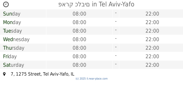
פארק כלבים
1275 7, תל אביב יפו
Park
read more
734 m
פארק כלבים
1275 Street 7, Tel Aviv-Yafo
Park
read more
858 m
גינת קלישר-התבור
קלישר 22, תל אביב יפו
Park
read more
858 m
גינת קלישר-התבור
Kalischer Street 22, Tel Aviv-Yafo
Park
read more
862 m
Калишер-Хатавор Гарден
Tel Aviv-Yafo
Park
read more
875 m
גינת כלבים לבנדה פינת עין הקורא
Ein HaKore Street 21, Tel Aviv-Yafo
Park
read more
882 m
גינת יעבץ התבור
יעבץ 16, תל אביב יפו
Park
read more
885 m
גן תבור
התבור 37, תל אביב יפו
Park
read more
885 m
Tavor Garden
HaTavor Street 37, Tel Aviv-Yafo
Park
read more
930 m
Mordehai Garden
Tel Aviv-Jaffa
Park
read more
968 m
Garden Hadas
HaAvoda Street 25, Tel Aviv-Yafo
Park
read more
968 m
גן הדס
העבודה 25, תל אביב יפו
Park
read more
985 m
גן לזכר מגיני תל אביב ולכובשי יפו
הכרמל 1, תל אביב יפו
Park
read more
985 m
גן לזכר מגיני תל אביב ולכובשי יפו
HaCarmel Street 1, Tel Aviv-Yafo
Park
read more
993 m
פארק קרית הספר
תל אביב יפו
Park
read more
1.036 km
Yehya Kapah Garden
Tel Aviv-Yafo
Park
read more
1.036 km
גינת יחיה קאפח
תל אביב יפו
Park
read more
1.089 km
גן אליפלט
אליפלט 20, תל אביב יפו
Park
read more
1.09 km
HaKovshim Garden
Тель-Авив
Park
read more
1.177 km
Gindi Park
1331 7-1, תל אביב יפו
Park
read more
1.309 km
Givon Square (Compound Givon)
Giv'on Street, Tel Aviv-Yafo
Park
read more
📑
all categories
Accounting
Administrative area level 1
Administrative area level 2
Airport
Amusement park
Aquarium
Art gallery
Atm
Bakery
Bank
Bar
Beauty salon
Bicycle store
Book store
Bowling alley
Bus station
Cafe
Campground
Car dealer
Car rental
Car repair
Car wash
Casino
Cemetery
Church
City hall
Clothing store
Colloquial area
Convenience store
Country
Courthouse
Dentist
Department store
Doctor
Electrician
Electronics store
Embassy
Establishment
Finance
Fire station
Florist
Food
Funeral home
Furniture store
Gas station
General contractor
Grocery or supermarket
Gym
Hair care
Hardware store
Health
Hindu Temple
Home goods store
Hospital
Insurance agency
Intersection
Jewelry store
Laundry
Lawyer
Library
Light rail station
Liquor store
Local government office
Locality
Locksmith
Lodging
Meal delivery
Meal takeaway
Mosque
Movie rental
Movie theater
Moving company
Museum
Natural feature
Neighborhood
Night club
Painter
Park
Parking
Pet store
Pharmacy
Physiotherapist
Place of worship
Plumber
Point of interest
Police
Political
Post office
Premise
Real estate agency
Restaurant
Roofing contractor
Route
Rv park, camping
School
Shoe store
Shopping mall
Spa
Stadium
Storage
Store
Subpremise
Subway station
Supermarket
Synagogue
Taxi stand
Train station
Transit station
Travel agency
University
Veterinary care
Zoo
administrative area level 3
administrative area level 4
sublocality level 1
↑