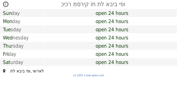
Park nearby גן קרוון
Coronavirus disease (COVID-19) Situation
confirmed cases
4841772
deaths
12707
Israel
Park nearby גן קרוון
גן קרוון
תל אביב יפו, ישראל
contacts phone
:
+972
Latitude:
32.075285
, Longitude:
34.777618
larger map & directions
read more
nearest Park
359 m
כיכר מסריק
תל אביב יפו
Park
read more
487 m
Meir Garden Dog Park
King George Street 35, Tel Aviv-Yafo
Park
read more
615 m
גן הדס
העבודה 25, תל אביב יפו
Park
read more
615 m
Garden Hadas
HaAvoda Street 25, Tel Aviv-Yafo
Park
read more
772 m
Mordehai Garden
Tel Aviv-Jaffa
Park
read more
818 m
Square Of The Rightous Amongst Nations
Hadassa Street 5, Tel Aviv-Yafo
Park
read more
849 m
פארק קרית הספר
תל אביב יפו
Park
read more
882 m
Ofman Dvora Garden
Тель-Авив
Park
read more
892 m
Givon Square (Compound Givon)
Giv'on Street, Tel Aviv-Yafo
Park
read more
908 m
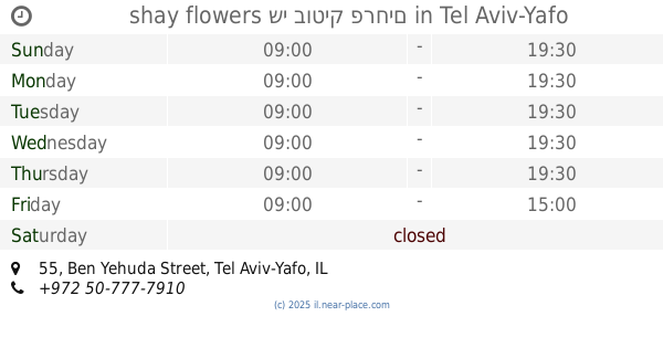
shay flowers שי בוטיק פרחים
Ben Yehuda Street 55, Tel Aviv-Yafo
Park
read more
908 m
shay flowers שי בוטיק פרחים
בן יהודה 55, תל אביב יפו
Park
read more
991 m
Ze'ev Garden
Tel Aviv-Yafo
Park
read more
1.004 km
Gindi Park
1331 7-1, תל אביב יפו
Park
read more
1.011 km
גינת פילצ׳וק
רופין 1-7, תל אביב יפו
Park
read more
1.137 km
Eran garden
Arnon Street 1, Tel Aviv-Yafo
Park
read more
1.139 km
גינת כלבים
נהרדעא, תל אביב יפו
Park
read more
1.144 km
גן ערן
תל אביב יפו
Park
read more
1.182 km
אזור התעשייה חולון
התעשייה, חולון
Park
read more
1.231 km
גינת יחיה קאפח
תל אביב יפו
Park
read more
1.231 km
Yehya Kapah Garden
Tel Aviv-Yafo
Park
read more
1.26 km
גן לזכר מגיני תל אביב ולכובשי יפו
HaCarmel Street 1, Tel Aviv-Yafo
Park
read more
1.281 km
Tavor Garden
HaTavor Street 37, Tel Aviv-Yafo
Park
read more
1.339 km
Калишер-Хатавор Гарден
Tel Aviv-Yafo
Park
read more
1.342 km
גינת קלישר-התבור
Kalischer Street 22, Tel Aviv-Yafo
Park
read more
1.342 km
גינת קלישר-התבור
קלישר 22, תל אביב יפו
Park
read more
📑
all categories
Accounting
Administrative area level 1
Administrative area level 2
Airport
Amusement park
Aquarium
Art gallery
Atm
Bakery
Bank
Bar
Beauty salon
Bicycle store
Book store
Bowling alley
Bus station
Cafe
Campground
Car dealer
Car rental
Car repair
Car wash
Casino
Cemetery
Church
City hall
Clothing store
Colloquial area
Convenience store
Country
Courthouse
Dentist
Department store
Doctor
Electrician
Electronics store
Embassy
Establishment
Finance
Fire station
Florist
Food
Funeral home
Furniture store
Gas station
General contractor
Grocery or supermarket
Gym
Hair care
Hardware store
Health
Hindu Temple
Home goods store
Hospital
Insurance agency
Intersection
Jewelry store
Laundry
Lawyer
Library
Light rail station
Liquor store
Local government office
Locality
Locksmith
Lodging
Meal delivery
Meal takeaway
Mosque
Movie rental
Movie theater
Moving company
Museum
Natural feature
Neighborhood
Night club
Painter
Park
Parking
Pet store
Pharmacy
Physiotherapist
Place of worship
Plumber
Point of interest
Police
Political
Post office
Premise
Real estate agency
Restaurant
Roofing contractor
Route
Rv park, camping
School
Shoe store
Shopping mall
Spa
Stadium
Storage
Store
Subpremise
Subway station
Supermarket
Synagogue
Taxi stand
Train station
Transit station
Travel agency
University
Veterinary care
Zoo
administrative area level 3
administrative area level 4
sublocality level 1
↑