Night club nearby אשקלטינו
Israel
Night club nearby אשקלטינו
אשקלטינו
שפינוזה 16/8, Ashkelon, Израиль
contacts phone
:
+972 50-420-2389
Latitude:
31.6618925
, Longitude:
34.5656437
larger map & directions
read more
nearest Night club
2.705 km
Karnaval
9 Ykotiel Adam St, Ashkelon
Night club
read more
3.417 km
Loft Ashkelon
א.ת.צפוני, Ashkelon
Night club
read more
3.417 km
לופט אשקלון
א.ת.צפוני, אשקלון
Night club
read more
11.787 km
עיבדיס-נגבה
Israel
Night club
read more
14.867 km
אחוזת דניאל
Mish'ol Hativat HaTsanhanim 20, Sderot
Night club
read more
15.949 km
Cadenza Outdoor Piano
Ha-Gdud ha-Ivri Street, Ashdod
Night club
read more
15.949 km
Cadenza Outdoor Piano
הגדוד העברי, אשדוד
Night club
read more
17.182 km
Media Noche Salsa Sapir
Israel
Night club
read more
17.305 km
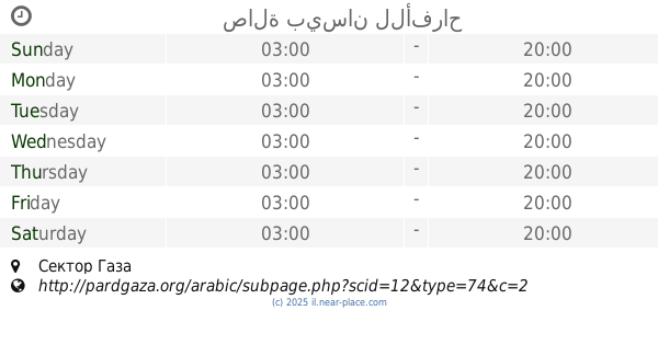
صالة بيسان للأفراح
Night club
read more
18.924 km
לופט בלקוני - לופט באשדוד
אשדוד,, העבודה 54, אשדוד
Night club
read more
18.924 km
לופט בלקוני
אשדוד,, Ha-Avoda Street 54, Ashdod
Night club
read more
18.924 km
לופט בלקוני - לופט באשדוד
אשדוד,, Ha-Avoda Street 54, Ashdod
Night club
read more
19.233 km
Pixel Club
אשדוד
Night club
read more
19.233 km
Pixel Club
Ashdod
Night club
read more
19.323 km
Karaoke rooms - Beat Ashdod
19, HaYahalomim Street, Ashdod
Night club
read more
19.323 km
חדרי קריוקי - ביט אשדוד
19, היהלומים, אשדוד
Night club
read more
19.351 km
صالة ابو هويدي Love Boot
Night club
read more
19.616 km
Loft La spa Relax
Ha-Amal Street 1, Ashdod
Night club
read more
20.079 km
Dell Club
Ha-Melakha Street, Ashdod
Night club
read more
21.829 km
فندق جولدن ستار
El-Rashid Street
Night club
read more
24.237 km
W - Roof & Club
Adom Street 20-24
Night club
read more
24.237 km
W - Roof & Club
אדום 20-24
Night club
read more
27.636 km
הבית של פינוקי
החרצית 49, קדרון
Night club
read more
28.839 km
Wedding Hall Abossrar
النصيرات دوار ابوصرار
Night club
read more
32.867 km
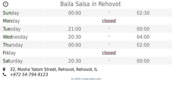
Baila Salsa
Moshe Yatom Street 32, Rehovot
Night club
read more
📑
all categories
Accounting
Administrative area level 1
Administrative area level 2
Airport
Amusement park
Aquarium
Art gallery
Atm
Bakery
Bank
Bar
Beauty salon
Bicycle store
Book store
Bowling alley
Bus station
Cafe
Campground
Car dealer
Car rental
Car repair
Car wash
Casino
Cemetery
Church
City hall
Clothing store
Colloquial area
Convenience store
Country
Courthouse
Dentist
Department store
Doctor
Electrician
Electronics store
Embassy
Establishment
Finance
Fire station
Florist
Food
Funeral home
Furniture store
Gas station
General contractor
Grocery or supermarket
Gym
Hair care
Hardware store
Health
Hindu Temple
Home goods store
Hospital
Insurance agency
Intersection
Jewelry store
Laundry
Lawyer
Library
Light rail station
Liquor store
Local government office
Locality
Locksmith
Lodging
Meal delivery
Meal takeaway
Mosque
Movie rental
Movie theater
Moving company
Museum
Natural feature
Neighborhood
Night club
Painter
Park
Parking
Pet store
Pharmacy
Physiotherapist
Place of worship
Plumber
Point of interest
Police
Political
Post office
Premise
Real estate agency
Restaurant
Roofing contractor
Route
Rv park, camping
School
Shoe store
Shopping mall
Spa
Stadium
Storage
Store
Subpremise
Subway station
Supermarket
Synagogue
Taxi stand
Train station
Transit station
Travel agency
University
Veterinary care
Zoo
administrative area level 3
administrative area level 4
sublocality level 1
↑