Museum nearby פארק המחצבה
Coronavirus disease (COVID-19) Situation
confirmed cases
4841772
deaths
12707
Israel
Museum nearby פארק המחצבה
פארק המחצבה
Кармиэль, Израиль
contacts phone
:
+972
Latitude:
32.9109276
, Longitude:
35.2906253
larger map & directions
read more
nearest Museum
1.01 km
Pini - Wood Craft
הפסגה 57, כרמיאל
Museum
read more
1.01 km
Pini - Wood Craft
Ha-Pisga Street 57, Karmiel
Museum
read more
7.654 km
אוסף מכוניות
מגדל תפן
Museum
read more
7.671 km
גלריה לאמנות
מגדל תפן
Museum
read more
7.861 km
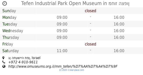
Tefen Industrial Park Open Museum
גן התעשייה תפן
Museum
read more
8.161 km
كنيسة اللاتين. Latin church הכנסייה הלטינית
ראמה
Museum
read more
8.97 km
בית יגאל עבאס
יאנוח ג'ת
Museum
read more
10.049 km
Heritage Center named after Lt. Col. Hosin Aamr
Julis
Museum
read more
10.087 km
Almaty headquarters Vineyard Alads
מטה אלמטה כרם אלעדס
Museum
read more
12.221 km
متحف مدين
כפר מנדא
Museum
read more
12.221 km
متحف مدين
Kafr Manda
Museum
read more
12.685 km
אדמוניות החורש
ליד בית, ג׳אן, Beit Jann
Museum
read more
12.796 km
متحف جاليري "ابداع"
Kafr Yasif
Museum
read more
12.796 km
متحف جاليري "ابداع"
כפר יאסיף
Museum
read more
12.898 km
חדר מורשת ע״ש אל״מ נבי מרעי ז״ל
Hurfeish
Museum
read more
12.898 km
חדר מורשת ע״ש אל״מ נבי מרעי ז״ל
חורפיש
Museum
read more
12.905 km
מרכז מורשת ע״ש אל״מ נביה מרעי
חורפיש
Museum
read more
13.024 km
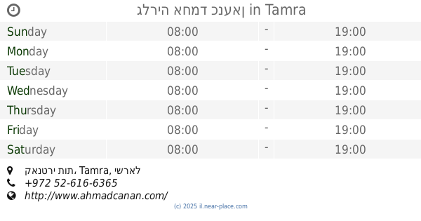
גלריה אחמד כנעאן
קאנטרי תות, Tamra
Museum
read more
13.502 km
Alsyar Neighbourhood
Bu'eine Nujeidat
Museum
read more
13.502 km
Alsyar Neighbourhood
בועיינה-נוג'ידאת
Museum
read more
13.519 km
חצר דאוד
אעבלין
Museum
read more
13.519 km
חצר דאוד
I'billin
Museum
read more
18.144 km
כברי גלריה שיתופית יהודית-ערבית
קיבוץ כברי, בניין חדר האוכל, Kabri
Museum
read more
18.586 km
מוזיאון גולני
Israel
Museum
read more
18.586 km
Golani Museum
Israel
Museum
read more
📑
all categories
Accounting
Administrative area level 1
Administrative area level 2
Airport
Amusement park
Aquarium
Art gallery
Atm
Bakery
Bank
Bar
Beauty salon
Bicycle store
Book store
Bowling alley
Bus station
Cafe
Campground
Car dealer
Car rental
Car repair
Car wash
Casino
Cemetery
Church
City hall
Clothing store
Colloquial area
Convenience store
Country
Courthouse
Dentist
Department store
Doctor
Electrician
Electronics store
Embassy
Establishment
Finance
Fire station
Florist
Food
Funeral home
Furniture store
Gas station
General contractor
Grocery or supermarket
Gym
Hair care
Hardware store
Health
Hindu Temple
Home goods store
Hospital
Insurance agency
Intersection
Jewelry store
Laundry
Lawyer
Library
Light rail station
Liquor store
Local government office
Locality
Locksmith
Lodging
Meal delivery
Meal takeaway
Mosque
Movie rental
Movie theater
Moving company
Museum
Natural feature
Neighborhood
Night club
Painter
Park
Parking
Pet store
Pharmacy
Physiotherapist
Place of worship
Plumber
Point of interest
Police
Political
Post office
Premise
Real estate agency
Restaurant
Roofing contractor
Route
Rv park, camping
School
Shoe store
Shopping mall
Spa
Stadium
Storage
Store
Subpremise
Subway station
Supermarket
Synagogue
Taxi stand
Train station
Transit station
Travel agency
University
Veterinary care
Zoo
administrative area level 3
administrative area level 4
sublocality level 1
↑