Mosque nearby مسجد شهداء الشاطئ
Coronavirus disease (COVID-19) Situation
confirmed cases
4841772
deaths
12707
Israel
Mosque nearby مسجد شهداء الشاطئ
مسجد شهداء الشاطئ
Газа
contacts phone
:
+972
Latitude:
31.5410533
, Longitude:
34.4510496
larger map & directions
read more
nearest Mosque
462 m
مسجد بغداد
El Bahr Street, Al Mahallah Al Kubra
Mosque
read more
462 m
مسجد بغداد
El Bahr Street, El-Mahalla El-Kubra
Mosque
read more
883 m
مسجد الخالدي
شمال, Gaza
Mosque
read more
1.073 km
المسجد الابيض
Gaza
Mosque
read more
1.109 km
مسجد النور والايمان
غزة اخر شارع النصر
Mosque
read more
1.343 km
مسجدالسوسي
Youssef Al-Adhameh Street, Amman
Mosque
read more
1.418 km
Масджид Ат-Таухид
Al Emdad & Al Tamween
Mosque
read more
1.516 km
مسجد الرضوان
Gaza
Mosque
read more
1.526 km
مسجد الفرقان
Bani Sweif - Giza
Mosque
read more
2.012 km
Borno Mosque
El-Imam El-Shafei
Mosque
read more
2.132 km
مسجد فلسطين
Falastin Street, Baghdad
Mosque
read more
2.15 km
مسجد أبو ذر الغفاري
Azza Street, Jerusalem
Mosque
read more
2.15 km
مسجد أبو ذر الغفاري
דרך עזה, ירושלים
Mosque
read more
2.28 km
مسجد التقوي
بجوار, Ahmed Aref 1
Mosque
read more
2.296 km
مسجد القدس
Ahmed Yaseen Street
Mosque
read more
2.586 km
مسجد الشهيد القائد سعيد صيام
תאופיק זיאד, שפרעם
Mosque
read more
2.628 km
Alhassina Mosque (مسجد الحساينة (الميناء
ميناء غزة البحري - الصيادين، غزة، قطاع غزة،
Mosque
read more
2.716 km
مسجد الفوز
Ebad El-Rahman
Mosque
read more
2.962 km
Mosque of faith
Sultans' Area Street, Beit Lahia
Mosque
read more
3.28 km
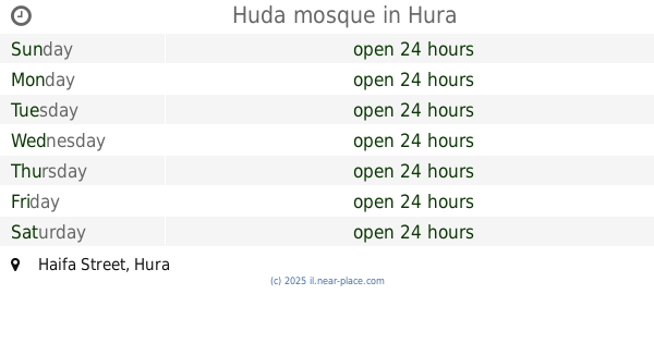
Huda mosque
Haifa Street, Hura
Mosque
read more
3.28 km
Huda mosque
חיפה, חורה
Mosque
read more
3.319 km
Hera Mosque
Jabalia
Mosque
read more
3.329 km
Mosque Prince Nayef
غزة, عطاطرة
Mosque
read more
3.543 km
Al Amin Mohammad Mosque
Al-Sheikh Al-Sha'rawy Street, Mansoura
Mosque
read more
3.806 km
Station mosque
Apple Street
Mosque
read more
📑
all categories
Accounting
Administrative area level 1
Administrative area level 2
Airport
Amusement park
Aquarium
Art gallery
Atm
Bakery
Bank
Bar
Beauty salon
Bicycle store
Book store
Bowling alley
Bus station
Cafe
Campground
Car dealer
Car rental
Car repair
Car wash
Casino
Cemetery
Church
City hall
Clothing store
Colloquial area
Convenience store
Country
Courthouse
Dentist
Department store
Doctor
Electrician
Electronics store
Embassy
Establishment
Finance
Fire station
Florist
Food
Funeral home
Furniture store
Gas station
General contractor
Grocery or supermarket
Gym
Hair care
Hardware store
Health
Hindu Temple
Home goods store
Hospital
Insurance agency
Intersection
Jewelry store
Laundry
Lawyer
Library
Light rail station
Liquor store
Local government office
Locality
Locksmith
Lodging
Meal delivery
Meal takeaway
Mosque
Movie rental
Movie theater
Moving company
Museum
Natural feature
Neighborhood
Night club
Painter
Park
Parking
Pet store
Pharmacy
Physiotherapist
Place of worship
Plumber
Point of interest
Police
Political
Post office
Premise
Real estate agency
Restaurant
Roofing contractor
Route
Rv park, camping
School
Shoe store
Shopping mall
Spa
Stadium
Storage
Store
Subpremise
Subway station
Supermarket
Synagogue
Taxi stand
Train station
Transit station
Travel agency
University
Veterinary care
Zoo
administrative area level 3
administrative area level 4
sublocality level 1
↑