Local government office nearby Qabatya Municipality
Coronavirus disease (COVID-19) Situation
confirmed cases
4841772
deaths
12707
Israel
Local government office nearby Qabatya Municipality
Qabatya Municipality
Main Street, Conway
contacts phone
:
+972
website:
www.facebook.com
Latitude:
32.4132586
, Longitude:
35.280319
larger map & directions
read more
nearest Local government office
938 m
Qabatiya police station
32°24'56.8"N 35°17'23., 5
Local government office
read more
5.583 km
Ahmed Sabaana Advocate Office
Jenin
Local government office
read more
16.988 km
Social Security
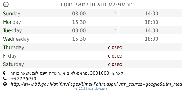
רחוב ראשי, מול סניף הדואר, אום אל-פאחם
Local government office
read more
16.988 km
ביטוח לאומי
רחוב ראשי, מול סניף הדואר, אום אל-פאחם
Local government office
read more
18.162 km
Kibbutz Beit Alfa
Beit Alfa
Local government office
read more
18.353 km
משרד החקלאות מחוז העמקים
Israel
Local government office
read more
21.134 km
Professional IT Service Comapny PITS
نابلس شارع البساتين, Nablus
Local government office
read more
21.265 km
Dotline adv.
Local government office
read more
21.27 km
משרד הרישוי עפולה
יהושע חנקין 14, עפולה
Local government office
read more
21.537 km
Институт Национального страхования Битуах леуми
Menahem Ussishkin Street 2, Afula
Local government office
read more
21.537 km
ביטוח לאומי
Menahem Ussishkin Street 2, Afula
Local government office
read more
22.472 km
ביטוח לאומי
Yerushalayim ha-Bira Street 9, Beit She'an
Local government office
read more
22.472 km
ביטוח לאומי
ירושלים הבירה 9, בית שאן
Local government office
read more
22.491 km
עיריית בית שאן
Yerushalayim ha-Bira Street 1, Beit She'an
Local government office
read more
22.491 km
עיריית בית שאן
ירושלים הבירה 1, בית שאן
Local government office
read more
22.506 km
שירות התעסוקה בית שאן
מקס נורדאו 14-24, בית שאן
Local government office
read more
22.506 km
שירות התעסוקה בית שאן
Max Nordau Street 14-24, Beit She'an
Local government office
read more
23 km
Harish local council
Harish
Local government office
read more
23 km
מועצה מקומית חריש
חריש
Local government office
read more
23.219 km
Afula railway station
Afula
Local government office
read more
23.258 km
Afula railway station terminal
כביש 65, Afula
Local government office
read more
23.258 km
מסוף תחנת רכבת עפולה
כביש 65, Afula
Local government office
read more
24.656 km
Har Bracha
קשתי 25, Bracha
Local government office
read more
26.028 km
Civil Defence Department
Grays Haddadin Street, Amman
Local government office
read more
26.599 km
Tulkarem municipality - Tulkarm-Palestine
Haret Helmy El Orabi
Local government office
read more
📑
all categories
Accounting
Administrative area level 1
Administrative area level 2
Airport
Amusement park
Aquarium
Art gallery
Atm
Bakery
Bank
Bar
Beauty salon
Bicycle store
Book store
Bowling alley
Bus station
Cafe
Campground
Car dealer
Car rental
Car repair
Car wash
Casino
Cemetery
Church
City hall
Clothing store
Colloquial area
Convenience store
Country
Courthouse
Dentist
Department store
Doctor
Electrician
Electronics store
Embassy
Establishment
Finance
Fire station
Florist
Food
Funeral home
Furniture store
Gas station
General contractor
Grocery or supermarket
Gym
Hair care
Hardware store
Health
Hindu Temple
Home goods store
Hospital
Insurance agency
Intersection
Jewelry store
Laundry
Lawyer
Library
Light rail station
Liquor store
Local government office
Locality
Locksmith
Lodging
Meal delivery
Meal takeaway
Mosque
Movie rental
Movie theater
Moving company
Museum
Natural feature
Neighborhood
Night club
Painter
Park
Parking
Pet store
Pharmacy
Physiotherapist
Place of worship
Plumber
Point of interest
Police
Political
Post office
Premise
Real estate agency
Restaurant
Roofing contractor
Route
Rv park, camping
School
Shoe store
Shopping mall
Spa
Stadium
Storage
Store
Subpremise
Subway station
Supermarket
Synagogue
Taxi stand
Train station
Transit station
Travel agency
University
Veterinary care
Zoo
administrative area level 3
administrative area level 4
sublocality level 1
↑