Local government office nearby بلديه الزوايده
Israel
Local government office nearby بلديه الزوايده
بلديه الزوايده
الزوايده، شارع الزوايده، الوسطى
contacts phone
:
+970 8 255 1140
website:
zawaida.ps
Latitude:
31.4331434
, Longitude:
34.3752923
larger map & directions
read more
nearest Local government office
10.509 km
Perfect Solution
مدينة غزة، تل الهوا، الرمال الجنوبي، بجوار وزارة التربية والتعليم
Local government office
read more
11.515 km
Technology And Communications Ministry
Omar Mukhtar Street
Local government office
read more
14.256 km
City Phone
Omar Mukhtar Street gaza
Local government office
read more
17.117 km
Labour North Branch Office
الشارع العام بيت لاهيا
Local government office
read more
19.127 km
War room floors and the Ministry of Community Manager
38, Mefalsim
Local government office
read more
19.127 km
חמל מפלסים ומשרד מנהל קהילה
38, מפלסים
Local government office
read more
19.9 km
ביטוח לאומי
הגפן 23, מרכז מסחרי לב נוי, נתיבות
Local government office
read more
19.9 km
ביטוח לאומי
הגפן 23, מרכז מסחרי לב נוי, Netivot
Local government office
read more
21.038 km
מזכירות עמיעוז
עמיעוז
Local government office
read more
21.264 km
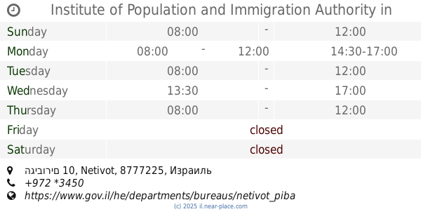
Institute of Population and Immigration Authority
הגיבורים 10, Netivot
Local government office
read more
21.306 km
שירות התעסוקה
סמלו 210, נתיבות
Local government office
read more
21.306 km
Employment Services
סמלו 210, נתיבות
Local government office
read more
21.402 km
מגדל מים
נתיבות
Local government office
read more
22.975 km
שירות התעסוקה
סמטת הפלדה 8, שדרות
Local government office
read more
22.976 km
שירות התעסוקה
Simtat HaPlada 8, Sderot
Local government office
read more
23.002 km
ביטוח לאומי
Ben Yehuda Street 21, Sderot
Local government office
read more
23.002 km
ביטוח לאומי
בן יהודה 21, שדרות
Local government office
read more
23.249 km
Kibbutz Migwan
השקד 1, שדרות
Local government office
read more
24.245 km
קיבוץ יד מרדכי
יד מרדכי
Local government office
read more
26.618 km
שירות התעסוקה
גולומב 8, אופקים
Local government office
read more
26.671 km
מחלקת גביה עיריית אופקים
Herzl Blvd 21, Ofakim
Local government office
read more
26.812 km
משרד רישוי אופקים
שדרות הרצל 685, אופקים
Local government office
read more
26.812 km
Office licensing horizons
Herzl Blvd 685, Ofakim
Local government office
read more
31.536 km
ועדה מקומית לתכנון ובניה חוף אשקלון
בת הדר
Local government office
read more
31.536 km
A local committee for planning and construction of the Hof Ashkelon
Bat Hadar
Local government office
read more
📑
all categories
Accounting
Administrative area level 1
Administrative area level 2
Airport
Amusement park
Aquarium
Art gallery
Atm
Bakery
Bank
Bar
Beauty salon
Bicycle store
Book store
Bowling alley
Bus station
Cafe
Campground
Car dealer
Car rental
Car repair
Car wash
Casino
Cemetery
Church
City hall
Clothing store
Colloquial area
Convenience store
Country
Courthouse
Dentist
Department store
Doctor
Electrician
Electronics store
Embassy
Establishment
Finance
Fire station
Florist
Food
Funeral home
Furniture store
Gas station
General contractor
Grocery or supermarket
Gym
Hair care
Hardware store
Health
Hindu Temple
Home goods store
Hospital
Insurance agency
Intersection
Jewelry store
Laundry
Lawyer
Library
Light rail station
Liquor store
Local government office
Locality
Locksmith
Lodging
Meal delivery
Meal takeaway
Mosque
Movie rental
Movie theater
Moving company
Museum
Natural feature
Neighborhood
Night club
Painter
Park
Parking
Pet store
Pharmacy
Physiotherapist
Place of worship
Plumber
Point of interest
Police
Political
Post office
Premise
Real estate agency
Restaurant
Roofing contractor
Route
Rv park, camping
School
Shoe store
Shopping mall
Spa
Stadium
Storage
Store
Subpremise
Subway station
Supermarket
Synagogue
Taxi stand
Train station
Transit station
Travel agency
University
Veterinary care
Zoo
administrative area level 3
administrative area level 4
sublocality level 1
↑