Health nearby איה תמרי יועצת לכלכלת המשפחה
Israel
Health nearby איה תמרי יועצת לכלכלת המשפחה
איה תמרי יועצת לכלכלת המשפחה
16, Agadim Street, 4724416, Ramat Hasharon, IL Израиль
contacts phone
:
+972 50-287-8778
website:
ayatamari.co.il
Latitude:
32.1355253
, Longitude:
34.839315
larger map & directions
read more
nearest Health
139 m
דר דקלה אנדר פוקס
הסייפן 41, רמת השרון
Health
read more
373 m
אורית מגלד בן אריה- דיאטנית קלינית
Sheshet ha-Yamim Street 6, Ramat Hasharon
Health
read more
486 m
רופא שיניים ברמת השרון
Ussishkin Street 22, Ramat Hasharon
Dentist
Point of interest
Health
Establishment
read more
549 m
מרכז רפואי רמת השרון
Ha-Netsakh Street 3, Ramat Hasharon
Hospital
Health
Point of interest
Establishment
read more
549 m
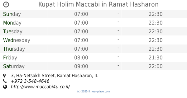
Kupat Holim Maccabi
Ha-Netsakh Street 3, Ramat Hasharon
Hospital
Health
Point of interest
Establishment
read more
621 m
kfir ben galil
סוקולוב 24, רמת השרון
Health
read more
691 m
Dr. Amir Gazmawe
Ussishkin Street 37, Ramat Hasharon
Dentist
Health
Point of interest
Establishment
read more
863 m
Optica Halperin
Sokolov Street 45, Ramat Hasharon
Health
read more
866 m
עולם המים של אורי סלע - סניף רמת השרון
Moshe Sneh Street 199, Ramat Hasharon
Health
read more
866 m
עולם המים של אורי סלע - סניף רמת השרון
משה סנה 199, רמת השרון
Health
read more
943 m
דר אייל בוצר
Ramat Hasharon
Dentist
Health
Point of interest
Establishment
read more
963 m
BWHITE | DR. MIKI BABAYEV
Ussishkin Street, Ramat Hasharon
Dentist
Health
Point of interest
Establishment
read more
993 m
דר מור בן ציון
HaMelachim Street 39, Ramat Hasharon
Dentist
Health
Point of interest
Establishment
read more
1.008 km
מרפאת השיניים של דר סטפן שאולוב
Sokolov Street 57/3, Ramat Hasharon
Dentist
Point of interest
Health
Establishment
read more
1.124 km
Kfar Ofarim
Moshe Sneh Street 199, Ramat Hasharon
Health
read more
📑
all categories
Accounting
Administrative area level 1
Administrative area level 2
Airport
Amusement park
Aquarium
Art gallery
Atm
Bakery
Bank
Bar
Beauty salon
Bicycle store
Book store
Bowling alley
Bus station
Cafe
Campground
Car dealer
Car rental
Car repair
Car wash
Casino
Cemetery
Church
City hall
Clothing store
Colloquial area
Convenience store
Country
Courthouse
Dentist
Department store
Doctor
Electrician
Electronics store
Embassy
Establishment
Finance
Fire station
Florist
Food
Funeral home
Furniture store
Gas station
General contractor
Grocery or supermarket
Gym
Hair care
Hardware store
Health
Hindu Temple
Home goods store
Hospital
Insurance agency
Intersection
Jewelry store
Laundry
Lawyer
Library
Light rail station
Liquor store
Local government office
Locality
Locksmith
Lodging
Meal delivery
Meal takeaway
Mosque
Movie rental
Movie theater
Moving company
Museum
Natural feature
Neighborhood
Night club
Painter
Park
Parking
Pet store
Pharmacy
Physiotherapist
Place of worship
Plumber
Point of interest
Police
Political
Post office
Premise
Real estate agency
Restaurant
Roofing contractor
Route
Rv park, camping
School
Shoe store
Shopping mall
Spa
Stadium
Storage
Store
Subpremise
Subway station
Supermarket
Synagogue
Taxi stand
Train station
Transit station
Travel agency
University
Veterinary care
Zoo
administrative area level 3
administrative area level 4
sublocality level 1
↑