Health nearby Поликлиника Клалит
Israel
Health nearby Поликлиника Клалит
Поликлиника Клалит
ערוער, Ar'ara BaNegev, Израиль
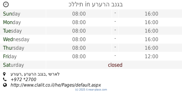
contacts phone
:
+972 *2700
website:
www.clalit.co.il
Latitude:
31.1653681
, Longitude:
35.0305945
larger map & directions
read more
nearest Health
כללית
ערוער, ערערה בנגב
Health
read more
כללית
ערוער, Ar'arat an-Naqab
Health
read more
5 m
Patients Clalit Fund
Ar'arat an-Naqab
Health
read more
22 m
Family Health Center
Ar'arat an-Naqab
Health
read more
22 m
תחנה לבריאות המשפחה
ערערה בנגב
Health
read more
274 m
Gimel Klallit Clinic
Ar'arat an-Naqab
Health
read more
940 m
קופח לאומית
ערערה בנגב
Health
read more
1.469 km
קופח כללית ב'
ערערה בנגב
Health
read more
1.469 km
קופח כללית ב'
Ar'arat an-Naqab
Health
read more
16.923 km
Kupat Kholim Klalit Hura Bet
Hura
Health
read more
17.001 km
טיפת חלב Mother and Child Health Center
Ibn Ta'imia Street 53, Hura
Health
read more
17.131 km
תחנה לבריאות המשפחה
חורה
Health
read more
17.191 km
שירות פסיכולוגי חינוכי
חורה
Health
read more
17.474 km
קופת חולים לאומית
Abu Basma Regional Council
Health
read more
17.516 km
קופת חולים כללית
אלפרוק 902, חורה
Health
read more
📑
all categories
Accounting
Administrative area level 1
Administrative area level 2
Airport
Amusement park
Aquarium
Art gallery
Atm
Bakery
Bank
Bar
Beauty salon
Bicycle store
Book store
Bowling alley
Bus station
Cafe
Campground
Car dealer
Car rental
Car repair
Car wash
Casino
Cemetery
Church
City hall
Clothing store
Colloquial area
Convenience store
Country
Courthouse
Dentist
Department store
Doctor
Electrician
Electronics store
Embassy
Establishment
Finance
Fire station
Florist
Food
Funeral home
Furniture store
Gas station
General contractor
Grocery or supermarket
Gym
Hair care
Hardware store
Health
Hindu Temple
Home goods store
Hospital
Insurance agency
Intersection
Jewelry store
Laundry
Lawyer
Library
Light rail station
Liquor store
Local government office
Locality
Locksmith
Lodging
Meal delivery
Meal takeaway
Mosque
Movie rental
Movie theater
Moving company
Museum
Natural feature
Neighborhood
Night club
Painter
Park
Parking
Pet store
Pharmacy
Physiotherapist
Place of worship
Plumber
Point of interest
Police
Political
Post office
Premise
Real estate agency
Restaurant
Roofing contractor
Route
Rv park, camping
School
Shoe store
Shopping mall
Spa
Stadium
Storage
Store
Subpremise
Subway station
Supermarket
Synagogue
Taxi stand
Train station
Transit station
Travel agency
University
Veterinary care
Zoo
administrative area level 3
administrative area level 4
sublocality level 1
↑