Health nearby Поликлиника Клалит
Israel
Health nearby Поликлиника Клалит
Поликлиника Клалит
10, Ha-Marganit Street, 52584, Ramat Gan, IL Израиль
contacts phone
:
+972 3-751-3783
website:
www.clalit.co.il
Latitude:
32.0936885
, Longitude:
34.8130166
larger map & directions
read more
nearest Health
417 m
Clalit
Abba Hillel Silver Road 77, Ramat Gan
Health
read more
460 m
Поликлиника Клалит
הגפן 23, ד.נ. חוף הכרמל, עין איילה
Health
read more
482 m
מרפאת הגפן Hagefen Clinic
HaMa'apil Street 2, Ramat Gan
Health
read more
668 m
Body Restart
Rashi Street 8, Ramat Gan
Hospital
Health
Point of interest
Establishment
read more
835 m
גן בעיר דיור מוגן
Doctor Cohen Street 12, Ramat Gan
Health
read more
839 m
SUNMOON Wellness Center • Дом Солнца и Луны
Ben Shemen Street 6, Ramat Gan
Health
read more
885 m
Медицинский центр G.A. Medical
32 Ben Gurion Road St Ramat Gan
Hospital
Health
Point of interest
Establishment
read more
885 m
א.ש. סיעוד רמת גן
Derech Ben Gurion 30, Ramat Gan
Health
read more
888 m
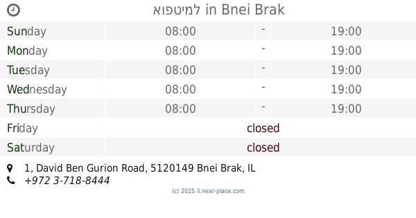
אופטימל
David Ben Gurion Road 1, Bnei Brak
Hospital
Health
Point of interest
Establishment
read more
890 m
מרכז רפואי א.פ.ק בריאות
David Ben Gurion Road 32, Ramat Gan
Hospital
Health
Point of interest
Establishment
read more
919 m
דר יסקין - השתלת שיניים בזאלית - שיקום הפה - הלבנת שיניים - ציפוי שיניים - רופא שיניים - מרפאת שיניים ברמת גן
Zeev Jabotinsky Street 138, Ramat Gan
Dentist
Doctor
Health
Point of interest
Establishment
read more
1.014 km
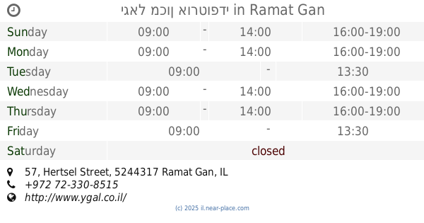
יגאל מכון אורטופדי
Hertsel Street 57, Ramat Gan
Health
read more
1.038 km
מרכז ההכשרה לקרניוסקראל אינטגרטיבי
הפרסה 1, רמת גן
Health
read more
1.07 km
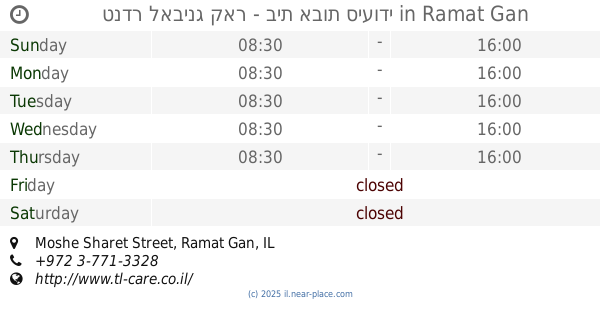
טנדר לאבינג קאר - בית אבות סיעודי
Moshe Sharet Street, Ramat Gan
Health
read more
1.276 km
Leora Grove
Ha-Rav Kharlap Street 12, Bnei Brak
Health
read more
📑
all categories
Accounting
Administrative area level 1
Administrative area level 2
Airport
Amusement park
Aquarium
Art gallery
Atm
Bakery
Bank
Bar
Beauty salon
Bicycle store
Book store
Bowling alley
Bus station
Cafe
Campground
Car dealer
Car rental
Car repair
Car wash
Casino
Cemetery
Church
City hall
Clothing store
Colloquial area
Convenience store
Country
Courthouse
Dentist
Department store
Doctor
Electrician
Electronics store
Embassy
Establishment
Finance
Fire station
Florist
Food
Funeral home
Furniture store
Gas station
General contractor
Grocery or supermarket
Gym
Hair care
Hardware store
Health
Hindu Temple
Home goods store
Hospital
Insurance agency
Intersection
Jewelry store
Laundry
Lawyer
Library
Light rail station
Liquor store
Local government office
Locality
Locksmith
Lodging
Meal delivery
Meal takeaway
Mosque
Movie rental
Movie theater
Moving company
Museum
Natural feature
Neighborhood
Night club
Painter
Park
Parking
Pet store
Pharmacy
Physiotherapist
Place of worship
Plumber
Point of interest
Police
Political
Post office
Premise
Real estate agency
Restaurant
Roofing contractor
Route
Rv park, camping
School
Shoe store
Shopping mall
Spa
Stadium
Storage
Store
Subpremise
Subway station
Supermarket
Synagogue
Taxi stand
Train station
Transit station
Travel agency
University
Veterinary care
Zoo
administrative area level 3
administrative area level 4
sublocality level 1
↑