Health nearby מרפאת הואדי
Coronavirus disease (COVID-19) Situation
confirmed cases
4841772
deaths
12707
Israel
Health nearby מרפאת הואדי
מרפאת הואדי
13, Sahyun Street, Haifa, Haifa, IL Israel
contacts phone
:
+972 4-862-0755
website:
www.wadiclinic.co.il
Latitude:
32.817469
, Longitude:
34.995222
larger map & directions
read more
nearest Health
258 m
לב הדר גיל הזהב
י.ל. פרץ 7, חיפה
Health
read more
258 m
לב הדר גיל הזהב
Y.L. Perets Street 7, Haifa
Health
read more
300 m
Studio 2Fit
הבנקים 5, חיפה
Health
read more
306 m
גיל עד עובדים זרים לסיעוד בעמ
עתלית 5, חיפה
Health
read more
309 m
מאוחדת
הדר מרפאת כאב,, Atlit
Health
read more
421 m
Leumit Health Fund
Haifa
Health
read more
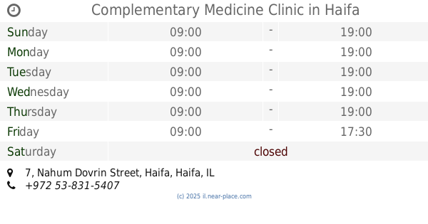
440 m
Complementary Medicine Clinic
Nahum Dovrin Street 7, Haifa
Health
read more
444 m
כללית - מרפאת ארמון
הנביאים 18, חיפה
Health
read more
468 m
בית מאי
חסן שוקרי 5, חיפה
Health
read more
493 m
Lotan nursing services
Herzliya Street 24, Haifa
Health
read more
493 m
לוטן שירותי סיעוד
הרצליה 24, חיפה
Health
read more
550 m
כללית התפתחות הילד
שדרות המגינים 90, חיפה
Health
read more
553 m
ביקורופא
שדרות בן גוריון 17, חיפה
Health
read more
617 m
Main Municipality Clinic
Haifa
Health
read more
636 m
Windsor Nursing Home
Sderot Ben Gurion 14, Haifa
Health
read more
694 m
מכון קינן שפי בע"מ
Sderot Ben Gurion 6, Haifa
Health
read more
790 m
כללית
שדרות המגינים 104, חיפה
Health
read more
878 m
בית אבות אחוזת לב
חיפה בלפור 11 חיפה IL 3313203, בלפור 11, חיפה
Health
read more
878 m
בית אבות אחוזת לב
חיפה בלפור 11 חיפה IL 3313203, Balfour Street 11, Haifa
Health
read more
919 m
בית גיל הזהב
חיפה
Health
read more
1.035 km
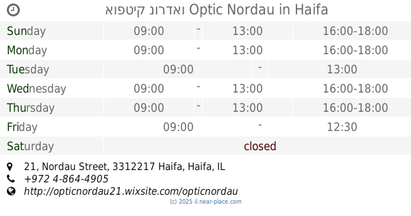
אופטיק נורדאו Optic Nordau
Nordau Street 21, Haifa
Health
read more
1.044 km
MDA Carmel
Yitshak Sadeh Street 10, Haifa
Health
read more
1.252 km
Поликлиника Клалит
Sderot James de Rothschild 37, Haifa
Health
read more
1.252 km
כללית מרכז בריאות האישה
שדרות ג'יימס דה רוטשילד 37, חיפה
Health
read more
1.306 km
Meuhedet Health Fund
Haifa
Health
read more
📑
all categories
Accounting
Administrative area level 1
Administrative area level 2
Airport
Amusement park
Aquarium
Art gallery
Atm
Bakery
Bank
Bar
Beauty salon
Bicycle store
Book store
Bowling alley
Bus station
Cafe
Campground
Car dealer
Car rental
Car repair
Car wash
Casino
Cemetery
Church
City hall
Clothing store
Colloquial area
Convenience store
Country
Courthouse
Dentist
Department store
Doctor
Electrician
Electronics store
Embassy
Establishment
Finance
Fire station
Florist
Food
Funeral home
Furniture store
Gas station
General contractor
Grocery or supermarket
Gym
Hair care
Hardware store
Health
Hindu Temple
Home goods store
Hospital
Insurance agency
Intersection
Jewelry store
Laundry
Lawyer
Library
Light rail station
Liquor store
Local government office
Locality
Locksmith
Lodging
Meal delivery
Meal takeaway
Mosque
Movie rental
Movie theater
Moving company
Museum
Natural feature
Neighborhood
Night club
Painter
Park
Parking
Pet store
Pharmacy
Physiotherapist
Place of worship
Plumber
Point of interest
Police
Political
Post office
Premise
Real estate agency
Restaurant
Roofing contractor
Route
Rv park, camping
School
Shoe store
Shopping mall
Spa
Stadium
Storage
Store
Subpremise
Subway station
Supermarket
Synagogue
Taxi stand
Train station
Transit station
Travel agency
University
Veterinary care
Zoo
administrative area level 3
administrative area level 4
sublocality level 1
↑