Health nearby מעבדת שיניים
Coronavirus disease (COVID-19) Situation
confirmed cases
4841772
deaths
12707
Israel
Health nearby מעבדת שיניים
מעבדת שיניים
Bi'ina, Israel
contacts phone
:
+972 4-998-8734
Latitude:
32.929538
, Longitude:
35.271917
larger map & directions
read more
nearest Health
181 m
Leumit Health Fund
Bi'ina
Health
read more
337 m
כללית
ד.נ. כרמיאל, Bi'ina
Health
read more
337 m
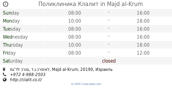
Поликлиника Клалит
ד.נ. כרמיאל, Bi'ina
Health
read more
337 m
כללית
ד.נ. כרמיאל, בענה
Health
read more
339 m
Patients Clalit Fund
Deir al-Asad
Health
read more
366 m
אורתודונטיה יישור שיניים ולסתות
Dayr al'Asad, Deir el-Asad
Dentist
Health
Point of interest
Establishment
read more
376 m
Center of Orthodontics and Aesthetics
אלג'בל, Deir al-Asad
Dentist
Health
Point of interest
Establishment
read more
424 m
חיאן שירותי רפואה דחופה
Albyan College, Bi'ina
Hospital
Health
Point of interest
Establishment
read more
430 m
Поликлиника Клалит
ביענה, ת.ד. 514 בענה, Bi'ina
Health
read more
430 m
כללית רפואה דחופה
ביענה, ת.ד. 514 בענה, בענה
Health
read more
430 m
כללית רפואה דחופה
ביענה, ת.ד. 514 בענה, Bi'ina
Health
read more
439 m
Pace Center for dental health
Deir al-Asad
Health
read more
1.761 km
אלדד מרום אימון אישי ועסקי כרמיאל
הדרור 18, כרמיאל
Health
read more
1.767 km
Поликлиника Клалит
מג'דל כרום, ד.נ.כרמיאל, Majd al-Krum
Health
read more
1.767 km
Clalit
מג'דל כרום, ד.נ.כרמיאל, Majd al-Krum
Health
read more
1.905 km
Family Health Center
Majd al-Krum
Health
read more
1.905 km
תחנה לבריאות המשפחה
מג'ד אל-כרום
Health
read more
2.193 km
Therapeutic Center for Infants
Karmiel
Health
read more
2.411 km
קופ"ח מאוחדת
Karmiel
Health
read more
2.411 km
קופח מאוחדת
כרמיאל
Health
read more
2.424 km
מאר מרכזים לאיבחון רפואי בעמ
Majd al-Krum
Health
read more
2.424 km
מאר מרכזים לאיבחון רפואי בעמ
מג'ד אל-כרום
Health
read more
2.434 km
Lilia
זמורה 7, כרמיאל
Health
read more
2.434 km
Lilia
Zmora Street 7, Karmiel
Health
read more
2.566 km
המרכז לטיפול במשפחה - כרמיאל
מירון 35, כרמיאל
Health
read more
📑
all categories
Accounting
Administrative area level 1
Administrative area level 2
Airport
Amusement park
Aquarium
Art gallery
Atm
Bakery
Bank
Bar
Beauty salon
Bicycle store
Book store
Bowling alley
Bus station
Cafe
Campground
Car dealer
Car rental
Car repair
Car wash
Casino
Cemetery
Church
City hall
Clothing store
Colloquial area
Convenience store
Country
Courthouse
Dentist
Department store
Doctor
Electrician
Electronics store
Embassy
Establishment
Finance
Fire station
Florist
Food
Funeral home
Furniture store
Gas station
General contractor
Grocery or supermarket
Gym
Hair care
Hardware store
Health
Hindu Temple
Home goods store
Hospital
Insurance agency
Intersection
Jewelry store
Laundry
Lawyer
Library
Light rail station
Liquor store
Local government office
Locality
Locksmith
Lodging
Meal delivery
Meal takeaway
Mosque
Movie rental
Movie theater
Moving company
Museum
Natural feature
Neighborhood
Night club
Painter
Park
Parking
Pet store
Pharmacy
Physiotherapist
Place of worship
Plumber
Point of interest
Police
Political
Post office
Premise
Real estate agency
Restaurant
Roofing contractor
Route
Rv park, camping
School
Shoe store
Shopping mall
Spa
Stadium
Storage
Store
Subpremise
Subway station
Supermarket
Synagogue
Taxi stand
Train station
Transit station
Travel agency
University
Veterinary care
Zoo
administrative area level 3
administrative area level 4
sublocality level 1
↑