Health nearby Margulits Day Center
Coronavirus disease (COVID-19) Situation
confirmed cases
4841772
deaths
12707
Israel
Health nearby Margulits Day Center
Margulits Day Center
Тель-Авив, Израиль
contacts phone
:
+972
Latitude:
32.0813089
, Longitude:
34.7914446
larger map & directions
read more
nearest Health
208 m
D.R.A Medical Group
ויצמן 14, תל אביב יפו
Health
read more
208 m
דוד גורדון מרפאת גינקולוגיה
Weizmann Street 14, Tel Aviv-Yafo
Health
read more
226 m
Arison New Hospitalization Building
Tel Aviv
Health
read more
333 m
מחלקת אשפוז האגף הישן
תל אביב יפו
Health
read more
590 m
טרילותרפיה
ז'בוטינסקי 133, תל אביב יפו
Health
read more
634 m
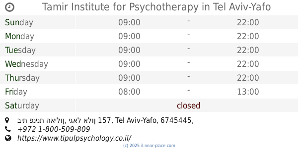
Tamir Institute for Psychotherapy
בית פנינת האילון, יגאל אלון 157, Tel Aviv-Yafo
Health
read more
725 m
רועי נאמן ג'יו ג'יטסו ברזילאי
Ben Shemen St 4, 3rd floor, תל אביב יפו
Health
read more
767 m
לישי סיטבון -יזם, ומאמן אישי ועסקי
שזיף, תל אביב יפו
Health
read more
797 m
Оптикана
קניון עזריאלי השלום, דרך מנחם בגין 132, תל אביב יפו
Health
read more
908 m
נוירוקליניק
Derech Menachem Begin 7, Ramat Gan
Hospital
Doctor
Health
Point of interest
Establishment
read more
939 m
מדיקיור - הדרכות ושירותים רפואיים (Medicure)
בית הלל 20, תל אביב יפו
Health
read more
941 m
גולן פרידמן לוי- מטפל שיאצו ומעסה Golan Friedman Levy- Shiatsu Therapist
Shlomo Ibn Gabirol Street 68, Tel Aviv-Yafo
Health
read more
1.014 km
MG.DIGITAL-גילוי מוקדם של סרטן השד
NOROK 6 ST, Tel Aviv-Yafo
Health
read more
1.052 km
דניאלה לר - פסיכותרפיסטית
שלמה אבן גבירול, תל אביב יפו
Health
read more
1.111 km
מדיקס את הום בדיקות רנטגן ואולטרסאונד בבית הלקוח
בצלאל 10, רמת גן
Health
read more
📑
all categories
Accounting
Administrative area level 1
Administrative area level 2
Airport
Amusement park
Aquarium
Art gallery
Atm
Bakery
Bank
Bar
Beauty salon
Bicycle store
Book store
Bowling alley
Bus station
Cafe
Campground
Car dealer
Car rental
Car repair
Car wash
Casino
Cemetery
Church
City hall
Clothing store
Colloquial area
Convenience store
Country
Courthouse
Dentist
Department store
Doctor
Electrician
Electronics store
Embassy
Establishment
Finance
Fire station
Florist
Food
Funeral home
Furniture store
Gas station
General contractor
Grocery or supermarket
Gym
Hair care
Hardware store
Health
Hindu Temple
Home goods store
Hospital
Insurance agency
Intersection
Jewelry store
Laundry
Lawyer
Library
Light rail station
Liquor store
Local government office
Locality
Locksmith
Lodging
Meal delivery
Meal takeaway
Mosque
Movie rental
Movie theater
Moving company
Museum
Natural feature
Neighborhood
Night club
Painter
Park
Parking
Pet store
Pharmacy
Physiotherapist
Place of worship
Plumber
Point of interest
Police
Political
Post office
Premise
Real estate agency
Restaurant
Roofing contractor
Route
Rv park, camping
School
Shoe store
Shopping mall
Spa
Stadium
Storage
Store
Subpremise
Subway station
Supermarket
Synagogue
Taxi stand
Train station
Transit station
Travel agency
University
Veterinary care
Zoo
administrative area level 3
administrative area level 4
sublocality level 1
↑