Health nearby Maccabi Dent
Israel
Health nearby Maccabi Dent
Maccabi Dent
7, Kineret Street, Ashdod, Ashkelon, IL Israel
contacts phone
:
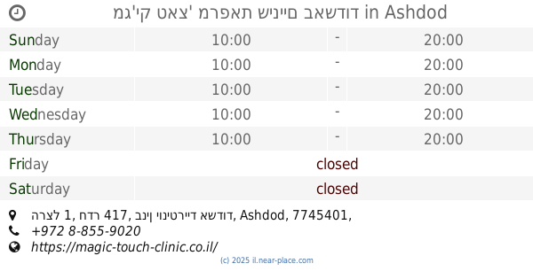
+972
Latitude:
31.7855372
, Longitude:
34.6310331
larger map & directions
read more
nearest Health
85 m
דר ליאפיס לריסה
Kineret Street 5, Ashdod
Dentist
Health
Point of interest
Establishment
read more
467 m
шапка мобайл3
Nahal Snir Street 4, Ashdod
Hospital
Health
Point of interest
Establishment
read more
537 m
whatsapp sender pro 2019 v 7.1
Kineret Street 51, Ashdod
Dentist
Insurance agency
Doctor
University
Health
Point of interest
Establishment
read more
886 m
דר ברונשטיין לאוניד LBDent
Adar Street 4/1, Ashdod
Dentist
Health
Point of interest
Establishment
read more
998 m
מרפאת שיניים
Adar Street, Ashdod
Dentist
Health
Point of interest
Establishment
read more
1.111 km
דר מקלר יבגני - רופא שיניים
מגדל דימרי, Tsahal 1, Ashdod
Dentist
Health
Point of interest
Establishment
read more
1.111 km
מרפאת שיניים דר לוי
צה"ל 1, אשדוד
Doctor
Dentist
Health
Point of interest
Establishment
read more
1.119 km
רופא שיניים
Tsahal Street, Ashdod
Dentist
Health
Point of interest
Establishment
read more
1.239 km
שנהב מרפאת שיניים
HaBanim Street 4, Ashdod
Dentist
Health
Point of interest
Establishment
read more
1.245 km
דר גרה מחמד
HaBanim Street 4, Ashdod
Dentist
Health
Point of interest
Establishment
read more
1.258 km
ד.א.פ. מרפאת שיניים
Sderot Herzl 1, Ashdod
Dentist
Health
Point of interest
Establishment
read more
1.258 km
מג'יק טאצ' מרפאת שיניים באשדוד
הרצל 1, חדר 417, בנין יוניטרייד אשדוד
Dentist
Health
Point of interest
Establishment
read more
1.258 km
בלבנובסקי אלכסנדר
Sderot Herzl 1, Ashdod
Dentist
Health
Point of interest
Establishment
read more
1.291 km
מכון מור
HaBanim Street 1, Ashdod
Hospital
Health
Point of interest
Establishment
read more
1.365 km
מרפאת שיניים באשדוד דר אולגה ניקולאיבסקי
שדרות ירושלים 18, משרד 404D קומה 4, K-Tower, Ashdod
Dentist
Health
Point of interest
Establishment
read more
📑
all categories
Accounting
Administrative area level 1
Administrative area level 2
Airport
Amusement park
Aquarium
Art gallery
Atm
Bakery
Bank
Bar
Beauty salon
Bicycle store
Book store
Bowling alley
Bus station
Cafe
Campground
Car dealer
Car rental
Car repair
Car wash
Casino
Cemetery
Church
City hall
Clothing store
Colloquial area
Convenience store
Country
Courthouse
Dentist
Department store
Doctor
Electrician
Electronics store
Embassy
Establishment
Finance
Fire station
Florist
Food
Funeral home
Furniture store
Gas station
General contractor
Grocery or supermarket
Gym
Hair care
Hardware store
Health
Hindu Temple
Home goods store
Hospital
Insurance agency
Intersection
Jewelry store
Laundry
Lawyer
Library
Light rail station
Liquor store
Local government office
Locality
Locksmith
Lodging
Meal delivery
Meal takeaway
Mosque
Movie rental
Movie theater
Moving company
Museum
Natural feature
Neighborhood
Night club
Painter
Park
Parking
Pet store
Pharmacy
Physiotherapist
Place of worship
Plumber
Point of interest
Police
Political
Post office
Premise
Real estate agency
Restaurant
Roofing contractor
Route
Rv park, camping
School
Shoe store
Shopping mall
Spa
Stadium
Storage
Store
Subpremise
Subway station
Supermarket
Synagogue
Taxi stand
Train station
Transit station
Travel agency
University
Veterinary care
Zoo
administrative area level 3
administrative area level 4
sublocality level 1
↑