Health nearby Maamats Treatment Center
Israel
Health nearby Maamats Treatment Center
Maamats Treatment Center
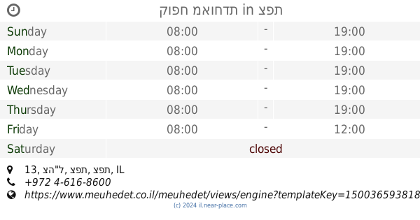
Safed, Israel
contacts phone
:
+972
Latitude:
32.9629023
, Longitude:
35.4821429
larger map & directions
read more
nearest Health
877 m
Light of Life Clinic
Tsahal Street 13, Safed
Health
read more
877 m
מרפאת מאור חיים
צה"ל 13, צפת
Health
read more
962 m
Leumit Safed light of life
Tsahal Street 13, Safed
Health
read more
962 m
קופ"ח לאומית צפת מאור חיים
צה"ל 13, צפת
Health
read more
971 m
קופח מאוחדת
צה"ל 13, צפת
Health
read more
971 m
קופ"ח מאוחדת
Tsahal Street 13, Safed
Health
read more
972 m
קופח כללית
צפת
Health
read more
1.027 km
ד"ר יצחק שטרן
ההגנה 175, צפת
Health
read more
1.027 km
פזיותרפיה לרצפת האגן
ההגנה 175, צפת
Health
read more
1.076 km
מעגלי אור - קרן הודיה
רחוב אבואב 26, צפת
Health
read more
1.106 km
In The Quiet Space
Safed
Health
read more
1.164 km
Contact Center Parents and Children
Safed
Health
read more
1.164 km
מרכז קשר הורים וילדים
צפת
Health
read more
1.36 km
רופא מוהל - דר דוד פלג
צפת
Health
read more
1.36 km
רופא מוהל - ד"ר דוד פלג
Safed
Health
read more
📑
all categories
Accounting
Administrative area level 1
Administrative area level 2
Airport
Amusement park
Aquarium
Art gallery
Atm
Bakery
Bank
Bar
Beauty salon
Bicycle store
Book store
Bowling alley
Bus station
Cafe
Campground
Car dealer
Car rental
Car repair
Car wash
Casino
Cemetery
Church
City hall
Clothing store
Colloquial area
Convenience store
Country
Courthouse
Dentist
Department store
Doctor
Electrician
Electronics store
Embassy
Establishment
Finance
Fire station
Florist
Food
Funeral home
Furniture store
Gas station
General contractor
Grocery or supermarket
Gym
Hair care
Hardware store
Health
Hindu Temple
Home goods store
Hospital
Insurance agency
Intersection
Jewelry store
Laundry
Lawyer
Library
Light rail station
Liquor store
Local government office
Locality
Locksmith
Lodging
Meal delivery
Meal takeaway
Mosque
Movie rental
Movie theater
Moving company
Museum
Natural feature
Neighborhood
Night club
Painter
Park
Parking
Pet store
Pharmacy
Physiotherapist
Place of worship
Plumber
Point of interest
Police
Political
Post office
Premise
Real estate agency
Restaurant
Roofing contractor
Route
Rv park, camping
School
Shoe store
Shopping mall
Spa
Stadium
Storage
Store
Subpremise
Subway station
Supermarket
Synagogue
Taxi stand
Train station
Transit station
Travel agency
University
Veterinary care
Zoo
administrative area level 3
administrative area level 4
sublocality level 1
↑