Health nearby IMS Israel
Israel
Health nearby IMS Israel
IMS Israel
4, Ariel Sharon Street, 5320047, Giv'atayim, IL Израиль
contacts phone
:
+972 3-573-6511
website:
www.ims-medstudy.com
Latitude:
32.0801981
, Longitude:
34.799507
larger map & directions
read more
nearest Health
525 m
מרכז רפואי שער העיר
Zeev Jabotinsky Street 7, Ramat Gan
Hospital
Health
Point of interest
Establishment
read more
565 m
נוירוקליניק
Derech Menachem Begin 7, Ramat Gan
Hospital
Doctor
Health
Point of interest
Establishment
read more
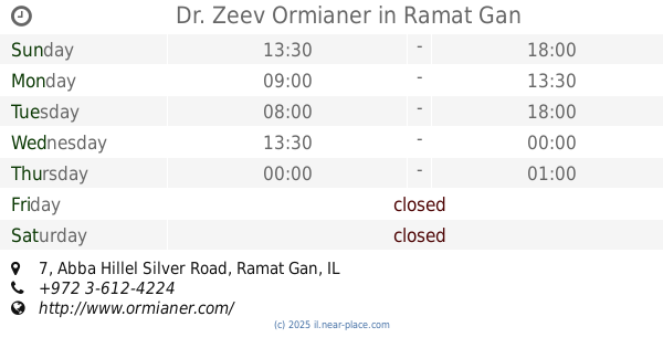
588 m
Dr. Zeev Ormianer
Abba Hillel Silver Road 7, Ramat Gan
Dentist
Health
Point of interest
Establishment
read more
592 m
מדיקיור - הדרכות ושירותים רפואיים (Medicure)
בית הלל 20, תל אביב יפו
Health
read more
713 m
רועי נאמן ג'יו ג'יטסו ברזילאי
Ben Shemen St 4, 3rd floor, תל אביב יפו
Health
read more
748 m
מדיקס את הום בדיקות רנטגן ואולטרסאונד בבית הלקוח
בצלאל 10, רמת גן
Health
read more
970 m
מחלקת אשפוז האגף הישן
תל אביב יפו
Health
read more
971 m
דר סמדר פקר - ניר / מומחית בכירורגיה- מנתחת סרטן השד
בורוכוב 54, גבעתיים
Hospital
Doctor
Health
Point of interest
Establishment
read more
978 m
דוד גורדון מרפאת גינקולוגיה
Weizmann Street 14, Tel Aviv-Yafo
Health
read more
978 m
D.R.A Medical Group
ויצמן 14, תל אביב יפו
Health
read more
988 m
Lundbeck Israel Ltd
דרך השלום 4, תל אביב יפו
Health
read more
1.015 km
Оптикана
קניון עזריאלי השלום, דרך מנחם בגין 132, תל אביב יפו
Health
read more
1.027 km
טרילותרפיה
ז'בוטינסקי 133, תל אביב יפו
Health
read more
1.09 km
פרופסור שמואל קיויתי - רופא מומחה לאלרגיה, אסטמה ודרכי נשימה
Katzenelson Street 68, Giv'atayim
Hospital
Doctor
Health
Point of interest
Establishment
read more
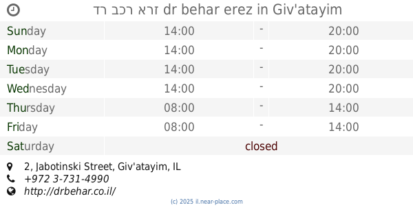
1.142 km
דר בכר ארז dr behar erez
Jabotinski Street 2, Giv'atayim
Dentist
Health
Point of interest
Establishment
read more
📑
all categories
Accounting
Administrative area level 1
Administrative area level 2
Airport
Amusement park
Aquarium
Art gallery
Atm
Bakery
Bank
Bar
Beauty salon
Bicycle store
Book store
Bowling alley
Bus station
Cafe
Campground
Car dealer
Car rental
Car repair
Car wash
Casino
Cemetery
Church
City hall
Clothing store
Colloquial area
Convenience store
Country
Courthouse
Dentist
Department store
Doctor
Electrician
Electronics store
Embassy
Establishment
Finance
Fire station
Florist
Food
Funeral home
Furniture store
Gas station
General contractor
Grocery or supermarket
Gym
Hair care
Hardware store
Health
Hindu Temple
Home goods store
Hospital
Insurance agency
Intersection
Jewelry store
Laundry
Lawyer
Library
Light rail station
Liquor store
Local government office
Locality
Locksmith
Lodging
Meal delivery
Meal takeaway
Mosque
Movie rental
Movie theater
Moving company
Museum
Natural feature
Neighborhood
Night club
Painter
Park
Parking
Pet store
Pharmacy
Physiotherapist
Place of worship
Plumber
Point of interest
Police
Political
Post office
Premise
Real estate agency
Restaurant
Roofing contractor
Route
Rv park, camping
School
Shoe store
Shopping mall
Spa
Stadium
Storage
Store
Subpremise
Subway station
Supermarket
Synagogue
Taxi stand
Train station
Transit station
Travel agency
University
Veterinary care
Zoo
administrative area level 3
administrative area level 4
sublocality level 1
↑