Health nearby Family health clinic
Israel
Health nearby Family health clinic
Family health clinic
25, Shlomo ha-Melekh Street, Ashdod, Ashkelon, IL Israel
contacts phone
:
+972 8-864-3326
Latitude:
31.7770244
, Longitude:
34.6473192
larger map & directions
read more
nearest Health
125 m
מחלקה אזורית לשירותים חברתיים
שלמה המלך 29, אשדוד
Health
read more
535 m
מרפאת שיניים סאמוטיס סרגיי
David HaMelech Street 18/53, Ashdod
Dentist
Doctor
Health
Point of interest
Establishment
read more
550 m
דר שביט מקסים
Amos ha-Navi Street 11, Ashdod
Dentist
Health
Point of interest
Establishment
read more
550 m
24 שעות
Amos ha-Navi Street 11, Ashdod
Dentist
Health
Point of interest
Establishment
read more
764 m
רופא שיניים דר יוסף בנימין
Hei be-Iyar Street 21, Ashdod
Dentist
Health
Point of interest
Establishment
read more
820 m
מרפאת שיניים
Adar Street, Ashdod
Dentist
Health
Point of interest
Establishment
read more
858 m
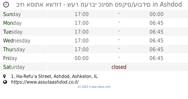
ביח אסותא אשדוד - שער מערבי כניסת ספקים/עובדים
Ha-Refu'a Street 1, Ashdod
Hospital
Health
Point of interest
Establishment
read more
880 m
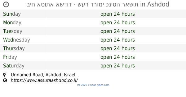
ביח אסותא אשדוד - שער דרומי כניסה ראשית
Unnamed Road, Ashdod
Hospital
Health
Point of interest
Establishment
read more
891 m
אסותא אשדוד - כניסה לחדר לידה
Ha-Refu'a Street, Ashdod
Hospital
Health
Point of interest
Establishment
read more
901 m
חדרי לידה אסותא
Ashdod
Hospital
Health
Point of interest
Establishment
read more
925 m
דר ברונשטיין לאוניד LBDent
Adar Street 4/1, Ashdod
Dentist
Health
Point of interest
Establishment
read more
938 m
Assuta Kalaniot Ashdod
Menachem Begin Boulevard 126, Ashdod
Hospital
Health
Point of interest
Establishment
read more
947 m
Samson Assuta Ashdod University Hospital
Ha-Refu'a Street 7, Ashdod
Hospital
Health
Point of interest
Establishment
read more
990 m
מרפאת שיניים באשדוד - I Smile רפואת שיניים מומחים וכללית
Sderot HaPrahim 28, Ashdod
Dentist
Doctor
Health
Point of interest
Establishment
read more
1.063 km
ביח אסותא - כניסה צפונית רגלית
ביה''ח אסותא, Ashdod
Hospital
Health
Point of interest
Establishment
read more
📑
all categories
Accounting
Administrative area level 1
Administrative area level 2
Airport
Amusement park
Aquarium
Art gallery
Atm
Bakery
Bank
Bar
Beauty salon
Bicycle store
Book store
Bowling alley
Bus station
Cafe
Campground
Car dealer
Car rental
Car repair
Car wash
Casino
Cemetery
Church
City hall
Clothing store
Colloquial area
Convenience store
Country
Courthouse
Dentist
Department store
Doctor
Electrician
Electronics store
Embassy
Establishment
Finance
Fire station
Florist
Food
Funeral home
Furniture store
Gas station
General contractor
Grocery or supermarket
Gym
Hair care
Hardware store
Health
Hindu Temple
Home goods store
Hospital
Insurance agency
Intersection
Jewelry store
Laundry
Lawyer
Library
Light rail station
Liquor store
Local government office
Locality
Locksmith
Lodging
Meal delivery
Meal takeaway
Mosque
Movie rental
Movie theater
Moving company
Museum
Natural feature
Neighborhood
Night club
Painter
Park
Parking
Pet store
Pharmacy
Physiotherapist
Place of worship
Plumber
Point of interest
Police
Political
Post office
Premise
Real estate agency
Restaurant
Roofing contractor
Route
Rv park, camping
School
Shoe store
Shopping mall
Spa
Stadium
Storage
Store
Subpremise
Subway station
Supermarket
Synagogue
Taxi stand
Train station
Transit station
Travel agency
University
Veterinary care
Zoo
administrative area level 3
administrative area level 4
sublocality level 1
↑