Health nearby ד"ר דוד נרוב - פסיכולוג קליני
Coronavirus disease (COVID-19) Situation
confirmed cases
4841772
deaths
12707
Israel
Health nearby ד"ר דוד נרוב - פסיכולוג קליני
ד"ר דוד נרוב - פסיכולוג קליני
Nissim Aloni Street 21, Tel Aviv-Yafo Израиль
contacts phone
:
+972
Latitude:
32.090926
, Longitude:
34.7969185
read more
nearest Health
357 m
אמיר מינץ שיאצו
Bavli Street 7, Tel Aviv-Yafo
Health
read more
537 m
Women's Clinic
Tel Aviv-Yafo
Health
read more
544 m
אוהד נחום
Toledano Street 10, Tel Aviv-Yafo
Health
read more
624 m
מדיקס את הום בדיקות רנטגן ואולטרסאונד בבית הלקוח
בצלאל 10, רמת גן
Health
read more
671 m
Поликлиника Клалит
Yerushalmi Street 11, Tel Aviv-Yafo
Health
read more
673 m
מדיקיור - הדרכות ושירותים רפואיים (Medicure)
בית הלל 20, תל אביב יפו
Health
read more
688 m
נוירוקליניק
Derech Menachem Begin 7, Ramat Gan
Hospital
Doctor
Health
Point of interest
Establishment
read more
689 m
טרילותרפיה
ז'בוטינסקי 133, תל אביב יפו
Health
read more
811 m
א.ש. סיעוד ורווחה
Ha-Khilazon Street 4, Ramat Gan
Health
read more
860 m
רותם רקובסקי
משה שרת 40, תל אביב יפו
Health
read more
916 m
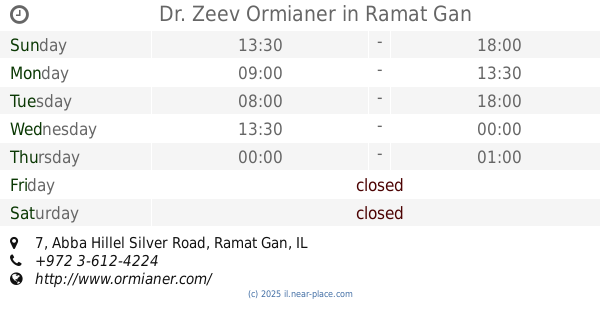
Dr. Zeev Ormianer
Abba Hillel Silver Road 7, Ramat Gan
Dentist
Health
Point of interest
Establishment
read more
953 m
Dr. Elias Mtanes - Specialist Plastic Surgeon
ז'בוטינסקי 7, קומה 21 ,העמותה הישראלית למנתחים פלסטיים אסתטיים, Ramat Gan
Health
read more
985 m
גיסנו ייעוץ
Arlozorov Street 141, Tel Aviv-Yafo
Health
read more
1.076 km
מרכז רפואי שער העיר
Zeev Jabotinsky Street 7, Ramat Gan
Hospital
Health
Point of interest
Establishment
read more
1.084 km
שפי שמחון בית ספר לרכיבה על אופניים
Rokach Boulevard 42, Tel Aviv-Yafo
Health
read more
📑
all categories
Accounting
Administrative area level 1
Administrative area level 2
Airport
Amusement park
Aquarium
Art gallery
Atm
Bakery
Bank
Bar
Beauty salon
Bicycle store
Book store
Bowling alley
Bus station
Cafe
Campground
Car dealer
Car rental
Car repair
Car wash
Casino
Cemetery
Church
City hall
Clothing store
Colloquial area
Convenience store
Country
Courthouse
Dentist
Department store
Doctor
Electrician
Electronics store
Embassy
Establishment
Finance
Fire station
Florist
Food
Funeral home
Furniture store
Gas station
General contractor
Grocery or supermarket
Gym
Hair care
Hardware store
Health
Hindu Temple
Home goods store
Hospital
Insurance agency
Intersection
Jewelry store
Laundry
Lawyer
Library
Light rail station
Liquor store
Local government office
Locality
Locksmith
Lodging
Meal delivery
Meal takeaway
Mosque
Movie rental
Movie theater
Moving company
Museum
Natural feature
Neighborhood
Night club
Painter
Park
Parking
Pet store
Pharmacy
Physiotherapist
Place of worship
Plumber
Point of interest
Police
Political
Post office
Premise
Real estate agency
Restaurant
Roofing contractor
Route
Rv park, camping
School
Shoe store
Shopping mall
Spa
Stadium
Storage
Store
Subpremise
Subway station
Supermarket
Synagogue
Taxi stand
Train station
Transit station
Travel agency
University
Veterinary care
Zoo
administrative area level 3
administrative area level 4
sublocality level 1
↑