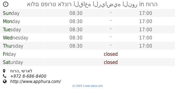
Gym nearby ستاد السموع الدولي
Israel
Gym nearby ستاد السموع الدولي
ستاد السموع الدولي
Samou Street, يطا
contacts phone
:
+972
Latitude:
31.4049516
, Longitude:
35.0696707
larger map & directions
read more
nearest Gym
14.94 km
Hebron Municipality closed hall
قرن الثور,الخليل
Gym
read more
17.1 km
Sports hall
Ibn Ta'imia Street 53, Hura
Gym
read more
17.452 km
אולם ספורט אלנור القاعه الرياضيه النور
חורה
Gym
read more
17.452 km
אולם ספורט אלנור القاعه الرياضيه النور
Hura
Gym
read more
19.397 km
مسلول الخيل
Israel
Gym
read more
21.005 km
פריים פיטנס קלאב
Elazar Ben Ya'ir Street 26, Arad
Gym
read more
21.01 km
Prime Fitness Club
Arad
Gym
read more
21.072 km
Yoga Retreat Ananda Rooms
Narkis Street 24, Arad
Gym
read more
21.072 km
Yoga Retreat Ananda Rooms
נרקיס 24, ערד
Gym
read more
21.155 km
מועדון כושר X-Fit
חן 34, ערד
Gym
read more
21.155 km
מועדון כושר אקס פיט
Hen Street 34, Arad
Gym
read more
21.519 km
סקייט פארק ערד
ערד
Gym
read more
21.584 km
FLOW Yoga House
Akhva Street 19, Arad
Gym
read more
21.584 km
FLOW Yoga House
אחווה 19, ערד
Gym
read more
24.307 km
עולם של יוגה
Sderot Tamar, Lehavim
Gym
read more
25.172 km
מועדון חברים - להבים
דרך שבעת המינים, להבים
Gym
read more
28.451 km
סטודיו לאימונים פונקציונאליים muscleup
המרד 13/1, Be'er Sheva
Gym
read more
28.451 km
סטודיו לאימונים פונקציונאליים
HaMered Street 13, Be'er Sheva
Gym
read more
28.895 km
אייקון פיטנס באר שבע
תורת היחסות 11, באר שבע
Gym
read more
29.782 km
המרכז ליוגה באר שבע
דרך השלום 103, באר שבע
Gym
read more
29.836 km
יוגה באר שבע
א.ל. זיסו 7, באר שבע
Gym
read more
30.216 km
Great Shape
Heil Handasa Street 1, Be'er Sheva
Gym
read more
30.216 km
גרייט שייפ
חיל הנדסה 1, באר שבע
Gym
read more
30.666 km
פעלטון אקטיב ג'מבורי לתינוקות וילדים
השדרה השביעית 48, באר שבע
Gym
read more
31.866 km
Toplink Crossfit
HaPo'alim Street 18, Be'er Sheva
Gym
read more
📑
all categories
Accounting
Administrative area level 1
Administrative area level 2
Airport
Amusement park
Aquarium
Art gallery
Atm
Bakery
Bank
Bar
Beauty salon
Bicycle store
Book store
Bowling alley
Bus station
Cafe
Campground
Car dealer
Car rental
Car repair
Car wash
Casino
Cemetery
Church
City hall
Clothing store
Colloquial area
Convenience store
Country
Courthouse
Dentist
Department store
Doctor
Electrician
Electronics store
Embassy
Establishment
Finance
Fire station
Florist
Food
Funeral home
Furniture store
Gas station
General contractor
Grocery or supermarket
Gym
Hair care
Hardware store
Health
Hindu Temple
Home goods store
Hospital
Insurance agency
Intersection
Jewelry store
Laundry
Lawyer
Library
Light rail station
Liquor store
Local government office
Locality
Locksmith
Lodging
Meal delivery
Meal takeaway
Mosque
Movie rental
Movie theater
Moving company
Museum
Natural feature
Neighborhood
Night club
Painter
Park
Parking
Pet store
Pharmacy
Physiotherapist
Place of worship
Plumber
Point of interest
Police
Political
Post office
Premise
Real estate agency
Restaurant
Roofing contractor
Route
Rv park, camping
School
Shoe store
Shopping mall
Spa
Stadium
Storage
Store
Subpremise
Subway station
Supermarket
Synagogue
Taxi stand
Train station
Transit station
Travel agency
University
Veterinary care
Zoo
administrative area level 3
administrative area level 4
sublocality level 1
↑