Gas station nearby פז ברורים
Israel
Gas station nearby פז ברורים
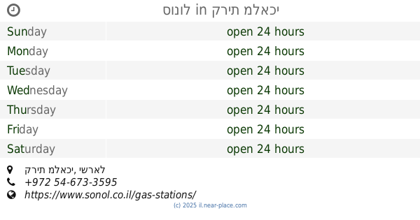
פז ברורים
צומת מסמיה, Kiryat Malakhi, Israel
contacts phone
:
+972 1-800-774-774
website:
www.paz.co.il
Latitude:
31.755055
, Longitude:
34.779182
larger map & directions
read more
nearest Gas station
7 m
Brurim
Israel
Gas station
read more
7 m
ברורים
Israel
Gas station
read more
557 m
דלק
Israel
Gas station
read more
765 m
צמיגי חיים אוזן
מסמיה אזור מלאכי
Gas station
read more
843 m
פז צומת ראם
צומת ראם, Kiryat Malakhi
Gas station
read more
843 m
פז צומת ראם
צומת ראם, קרית מלאכי
Gas station
read more
924 m
מתחם פז סנטר צומת ראם
כביש 40, בני רא"ם
Gas station
read more
924 m
Paz compound Ram junction Center
כביש 40, Bnei Re'em
Gas station
read more
1.217 km
Re'em
Israel
Gas station
read more
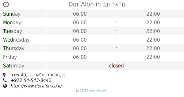
1.941 km
Dor Alon
כביש 40, בני רא"ם
Gas station
read more
2.566 km
Kfar Akhim
Kfar Ahim
Gas station
read more
2.566 km
כפר אחים
כפר אחים
Gas station
read more
3.123 km
דלק קרית מלאכי
פקר 1, קרית מלאכי
Gas station
read more
3.123 km
Delek Kiryat Malakhi
Peker Street 1, Kiryat Malakhi
Gas station
read more
3.123 km
Delek
Peker Street 1, Kiryat Malakhi
Gas station
read more
3.151 km
שטיפת רכבים דיסקאונט קסטינה
קרית מלאכי
Gas station
read more
3.151 km
שטיפת רכבים דיסקאונט קסטינה
Kiryat Malakhi
Gas station
read more
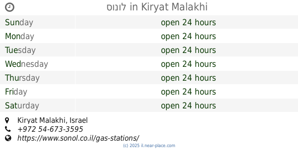
3.472 km
סונול
Kiryat Malakhi
Gas station
read more
3.472 km
סונול
קרית מלאכי
Gas station
read more
3.615 km
פז קרית מלאכי
צה"ל, קרית מלאכי
Gas station
read more
3.615 km
Paz Kiryat Malachi
צה"ל, קרית מלאכי
Gas station
read more
4.605 km
סדש תימורים
Timorim
Gas station
read more
4.789 km
תחנת דלק טן
באר טוביה, Asif Street
Gas station
read more
5.226 km
תחנת דלק סונול
כחול
Gas station
read more
5.244 km
נתיבים 91 בעמ
Be'er Tuvia
Gas station
read more
📑
all categories
Accounting
Administrative area level 1
Administrative area level 2
Airport
Amusement park
Aquarium
Art gallery
Atm
Bakery
Bank
Bar
Beauty salon
Bicycle store
Book store
Bowling alley
Bus station
Cafe
Campground
Car dealer
Car rental
Car repair
Car wash
Casino
Cemetery
Church
City hall
Clothing store
Colloquial area
Convenience store
Country
Courthouse
Dentist
Department store
Doctor
Electrician
Electronics store
Embassy
Establishment
Finance
Fire station
Florist
Food
Funeral home
Furniture store
Gas station
General contractor
Grocery or supermarket
Gym
Hair care
Hardware store
Health
Hindu Temple
Home goods store
Hospital
Insurance agency
Intersection
Jewelry store
Laundry
Lawyer
Library
Light rail station
Liquor store
Local government office
Locality
Locksmith
Lodging
Meal delivery
Meal takeaway
Mosque
Movie rental
Movie theater
Moving company
Museum
Natural feature
Neighborhood
Night club
Painter
Park
Parking
Pet store
Pharmacy
Physiotherapist
Place of worship
Plumber
Point of interest
Police
Political
Post office
Premise
Real estate agency
Restaurant
Roofing contractor
Route
Rv park, camping
School
Shoe store
Shopping mall
Spa
Stadium
Storage
Store
Subpremise
Subway station
Supermarket
Synagogue
Taxi stand
Train station
Transit station
Travel agency
University
Veterinary care
Zoo
administrative area level 3
administrative area level 4
sublocality level 1
↑