Gas station nearby Paz Elishema
Israel
Gas station nearby Paz Elishema
Paz Elishema
HaNarkis Street, Elishama, Petach Tikva, IL Israel
contacts phone
:
+972 1-800-774-774
website:
www.paz.co.il
Latitude:
32.152852
, Longitude:
34.921448
larger map & directions
read more
nearest Gas station
304 m
Delek Nina
Ha-Patish Street 12, Hod Hasharon
Gas station
read more
304 m
דלק
הפטיש 12, הוד השרון
Gas station
read more
304 m
Delek
Ha-Patish Street 12, Hod Hasharon
Gas station
read more
307 m
I.t.g. Tires Ltd - Tire Shop
Mevo Kedem, Hod Hasharon
Gas station
read more
307 m
י.ט.ג. צמיגים בע"מ - פנצ'ריה
מבוא קדם, הוד השרון
Gas station
read more
1.445 km
Ten East Kfar Saba
Atir Yeda Street 6, Kefar Sava
Gas station
read more
1.445 km
טן כפר סבא מזרח
עתיר ידע 6, כפר סבא
Gas station
read more
1.604 km
Paz Kfar Saba East
אזור תעשיה עתיר ידע, כפר סבא
Gas station
read more
1.604 km
פז כפר סבא מזרח
אזור תעשיה עתיר ידע, כפר סבא
Gas station
read more
1.635 km
פז חברת נפט, עתיר ידע תחנה 251
עתיר ידע 2, כפר סבא
Gas station
read more
1.635 km
פז חברת נפט, עתיר ידע תחנה 251
Atir Yeda Street 2, Kefar Sava
Gas station
read more
1.801 km
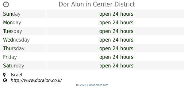
Dor Alon
Israel
Gas station
read more
2.066 km
תחנת דלק סונול
Unnamed Road, Kefar Sava
Gas station
read more
2.094 km
ביסקוויט
כפר סבא
Gas station
read more
2.106 km
סופר אלונית
HaTa'as Street 1, Kefar Sava
Gas station
read more
2.141 km
תחנת דור אלון
התע"ש 1, כפר סבא
Gas station
read more
2.363 km
Neve Yarak
Neve Yarak
Gas station
read more
2.496 km
Delek Ramatayim
Ramatayim Road, Hod Hasharon
Gas station
read more
2.544 km
פז חגור
כביש 444, חגור
Gas station
read more
2.566 km
פז הוד השרון
דרך רמתיים 98, הוד השרון
Gas station
read more
2.576 km
Сьём Прицепа
יוחנן הסנדלר 8, כפר סבא
Gas station
read more
2.922 km
תחנת איצטדיון כס
HaTa'as Street 32, Kefar Sava
Gas station
read more
3.113 km
Delek Gas Station
6, HaHarash Street 6, Hod Hasharon
Gas station
read more
3.446 km
Sonol gas station
Nir Street 2-4, Kefar Sava
Gas station
read more
3.643 km
תחנת דלק טן
הצומת 7, כפר סבא
Gas station
read more
📑
all categories
Accounting
Administrative area level 1
Administrative area level 2
Airport
Amusement park
Aquarium
Art gallery
Atm
Bakery
Bank
Bar
Beauty salon
Bicycle store
Book store
Bowling alley
Bus station
Cafe
Campground
Car dealer
Car rental
Car repair
Car wash
Casino
Cemetery
Church
City hall
Clothing store
Colloquial area
Convenience store
Country
Courthouse
Dentist
Department store
Doctor
Electrician
Electronics store
Embassy
Establishment
Finance
Fire station
Florist
Food
Funeral home
Furniture store
Gas station
General contractor
Grocery or supermarket
Gym
Hair care
Hardware store
Health
Hindu Temple
Home goods store
Hospital
Insurance agency
Intersection
Jewelry store
Laundry
Lawyer
Library
Light rail station
Liquor store
Local government office
Locality
Locksmith
Lodging
Meal delivery
Meal takeaway
Mosque
Movie rental
Movie theater
Moving company
Museum
Natural feature
Neighborhood
Night club
Painter
Park
Parking
Pet store
Pharmacy
Physiotherapist
Place of worship
Plumber
Point of interest
Police
Political
Post office
Premise
Real estate agency
Restaurant
Roofing contractor
Route
Rv park, camping
School
Shoe store
Shopping mall
Spa
Stadium
Storage
Store
Subpremise
Subway station
Supermarket
Synagogue
Taxi stand
Train station
Transit station
Travel agency
University
Veterinary care
Zoo
administrative area level 3
administrative area level 4
sublocality level 1
↑