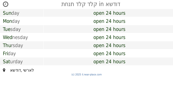
Gas station nearby מיקה -תחנת דלק בני ברית
Israel
Gas station nearby מיקה -תחנת דלק בני ברית
מיקה -תחנת דלק בני ברית
אשדוד, ישראל
contacts phone
:
+972
website:
www.mika.org.il
Latitude:
31.813261
, Longitude:
34.665164
larger map & directions
read more
nearest Gas station
Mika transformer Fuel allies
Ashdod
Gas station
read more
160 m
Сонол
Sderot Bnei Brit, Ashdod
Gas station
read more
160 m
סונול בני ברית
Sderot Bnei Brit, Ashdod
Gas station
read more
214 m
Gas station 7seven
Ashdod
Gas station
read more
220 m
Dor Alon - Rom
Ha-Avoda Street 43, Ashdod
Gas station
read more
236 m
Paz Ashdod City
Sderot Bnei Brit, Ashdod
Gas station
read more
389 m
תחנת דלק דלק
Ashdod
Gas station
read more
389 m
תחנת דלק דלק
אשדוד
Gas station
read more
405 m
Ashdod vehicle center
Ashdod
Gas station
read more
591 m
אשדוד צמר
אשדוד
Gas station
read more
710 m
תחנת הבושם אשדוד
Ha-Bosem Street 3, Ashdod
Gas station
read more
710 m
תחנת הבושם אשדוד
הבושם 3, אשדוד
Gas station
read more
737 m
פז הבושם אשדוד
Ha-Bosem Street 3, Ashdod
Gas station
read more
769 m
Star Center gas station
סטאר סנטר, שדרות בן גוריון, אשדוד
Gas station
read more
769 m
Delek Star Center
סטאר סנטר, שדרות בן גוריון, אשדוד
Gas station
read more
795 m
Tapuz
Ashdod
Gas station
read more
814 m
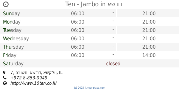
Ten - Jambo
איזור התעשייה בחניית ג'מבו, הבושם 7, אשדוד
Gas station
read more
822 m
תפוז
בן גוריון 18, אשדוד
Gas station
read more
885 m
Beit Gavriel
Ashdod
Gas station
read more
886 m
פז
האורגים 31, אשדוד
Gas station
read more
890 m
פז תחנת דלק
HaOrgim Street 31, Ashdod
Gas station
read more
916 m
opera house
HaOrgim Street 25, Ashdod
Gas station
read more
916 m
בית האופרה
האורגים 25, אשדוד
Gas station
read more
1.357 km
פז yellow ניר גלים
אשדוד
Gas station
read more
1.357 km
פז yellow ניר גלים
Ashdod
Gas station
read more
📑
all categories
Accounting
Administrative area level 1
Administrative area level 2
Airport
Amusement park
Aquarium
Art gallery
Atm
Bakery
Bank
Bar
Beauty salon
Bicycle store
Book store
Bowling alley
Bus station
Cafe
Campground
Car dealer
Car rental
Car repair
Car wash
Casino
Cemetery
Church
City hall
Clothing store
Colloquial area
Convenience store
Country
Courthouse
Dentist
Department store
Doctor
Electrician
Electronics store
Embassy
Establishment
Finance
Fire station
Florist
Food
Funeral home
Furniture store
Gas station
General contractor
Grocery or supermarket
Gym
Hair care
Hardware store
Health
Hindu Temple
Home goods store
Hospital
Insurance agency
Intersection
Jewelry store
Laundry
Lawyer
Library
Light rail station
Liquor store
Local government office
Locality
Locksmith
Lodging
Meal delivery
Meal takeaway
Mosque
Movie rental
Movie theater
Moving company
Museum
Natural feature
Neighborhood
Night club
Painter
Park
Parking
Pet store
Pharmacy
Physiotherapist
Place of worship
Plumber
Point of interest
Police
Political
Post office
Premise
Real estate agency
Restaurant
Roofing contractor
Route
Rv park, camping
School
Shoe store
Shopping mall
Spa
Stadium
Storage
Store
Subpremise
Subway station
Supermarket
Synagogue
Taxi stand
Train station
Transit station
Travel agency
University
Veterinary care
Zoo
administrative area level 3
administrative area level 4
sublocality level 1
↑