Gas station nearby דש בילינסון
Israel
Gas station nearby דש בילינסון
דש בילינסון
פתח תקווה, ישראל
contacts phone
:
+972 3-924-5260
Latitude:
32.09137
, Longitude:
34.864852
larger map & directions
read more
nearest Gas station
25 m
Dor Alon gas station
Ze'ev Jabotinsky Street 52, Petah Tikva
Gas station
read more
25 m
תחנת דלק דור אלון
רח' זאב ז'בוטינסקי 52, פתח תקווה
Gas station
read more
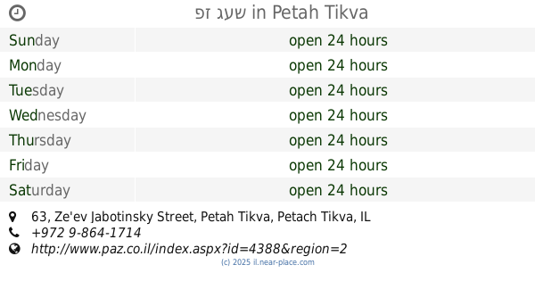
388 m
Паз
Derech Yitshak Rabin, Petah Tikva
Gas station
read more
388 m
פז נוה עוז
דרך יצחק רבין, פתח תקווה
Gas station
read more
432 m
Делек
Moshe Dayan Street 14, Petah Tikva
Gas station
read more
432 m
דלק
משה דיין 14, פתח תקווה
Gas station
read more
512 m
Паз
Ze'ev Jabotinsky Street 63, Petah Tikva
Gas station
read more
512 m
פז געש
Ze'ev Jabotinsky Street 63, Petah Tikva
Gas station
read more
512 m
פז געש
Ze'ev Jabotinsky Road 63, Petah Tikva
Gas station
read more
602 m
תחנת דלק טן
Moshe Dayan Street 72, Petah Tikva
Gas station
read more
602 m
תחנת דלק טן
משה דיין 72, פתח תקווה
Gas station
read more
626 m
Gissin Petah Tikva
Petah Tikva
Gas station
read more
695 m
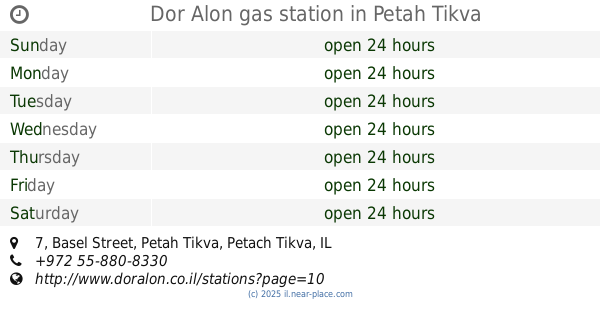
Dor Alon gas station
Basel Street 7, Petah Tikva
Gas station
read more
735 m
Сонол
Ha-Sivim Street 3, Petah Tikva
Gas station
read more
742 m
Mika Petakh Tikva
Petah Tikva
Gas station
read more
746 m
ריחן תידלוק בעמ
אבשלום גיסין 63, פתח תקווה
Gas station
read more
755 m
פז אם המושבות
אבשלום גיסין 65, פתח תקווה
Gas station
read more
760 m
הסיבים
Petah Tikva
Gas station
read more
760 m
דור אלון רחוב הסיבים
פתח תקווה
Gas station
read more
787 m
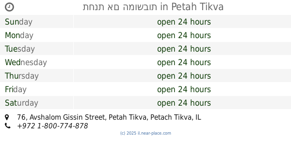
תחנת אם המושבות
Avshalom Gissin Street 76, Petah Tikva
Gas station
read more
795 m
מפגש השרון
פתח תקווה
Gas station
read more
1.057 km
טן גבעת שמואל
הסיבים 51, פתח תקווה
Gas station
read more
1.074 km
טן גבעת שמואל
Ha-Sivim Street 51, Petah Tikva
Gas station
read more
1.155 km
Danib Park
פתח תקווה
Gas station
read more
1.155 km
Danib Park
Petah Tikva
Gas station
read more
📑
all categories
Accounting
Administrative area level 1
Administrative area level 2
Airport
Amusement park
Aquarium
Art gallery
Atm
Bakery
Bank
Bar
Beauty salon
Bicycle store
Book store
Bowling alley
Bus station
Cafe
Campground
Car dealer
Car rental
Car repair
Car wash
Casino
Cemetery
Church
City hall
Clothing store
Colloquial area
Convenience store
Country
Courthouse
Dentist
Department store
Doctor
Electrician
Electronics store
Embassy
Establishment
Finance
Fire station
Florist
Food
Funeral home
Furniture store
Gas station
General contractor
Grocery or supermarket
Gym
Hair care
Hardware store
Health
Hindu Temple
Home goods store
Hospital
Insurance agency
Intersection
Jewelry store
Laundry
Lawyer
Library
Light rail station
Liquor store
Local government office
Locality
Locksmith
Lodging
Meal delivery
Meal takeaway
Mosque
Movie rental
Movie theater
Moving company
Museum
Natural feature
Neighborhood
Night club
Painter
Park
Parking
Pet store
Pharmacy
Physiotherapist
Place of worship
Plumber
Point of interest
Police
Political
Post office
Premise
Real estate agency
Restaurant
Roofing contractor
Route
Rv park, camping
School
Shoe store
Shopping mall
Spa
Stadium
Storage
Store
Subpremise
Subway station
Supermarket
Synagogue
Taxi stand
Train station
Transit station
Travel agency
University
Veterinary care
Zoo
administrative area level 3
administrative area level 4
sublocality level 1
↑