Establishment nearby Jacobs Bakery
Israel
Establishment nearby Jacobs Bakery
Jacobs Bakery
19, Haroshet Street, Ramat Hasharon, IL Israel
contacts phone
:
+972 3-549-1000
website:
www.bread.co.il
Latitude:
32.1293076
, Longitude:
34.8590827
larger map & directions
read more
nearest Establishment
77 m
דר אירית שחם D.M.D אסתטיקת פנים וצוואר
החרושת 18, רמת השרון
Dentist
Health
Point of interest
Establishment
read more
192 m
מרכז מסירה פיקניק
Haroshet Street 5, Ramat Hasharon
Post office
Finance
Point of interest
Establishment
read more
673 m
Teamim
Shivtei Israel Street 102, Ramat Hasharon
Supermarket
Grocery or supermarket
Food
Point of interest
Store
Establishment
read more
701 m
Bank Hapoalim ATM
Lakhish Street 2-8, Ramat Hasharon
Atm
Finance
Point of interest
Establishment
read more
948 m
דואר ישראל סניף ריינס
HaRav Reines Street 19, Ramat Hasharon
Post office
Finance
Point of interest
Establishment
read more
948 m
Post Office || סניף דואר
פינת, הרב ריינס 19, רמת השרון
Post office
Finance
Point of interest
Establishment
read more
1.004 km
שאולי מרקט רמת השרון
HaRav Kuk Street 41, Ramat Hasharon
Supermarket
Grocery or supermarket
Store
Point of interest
Food
Establishment
read more
1.075 km
Plowing with sageil 13
Unnamed Road،رمات, هشارون, Ramat Hasharon
Lodging
Point of interest
Establishment
read more
1.135 km
דר מור בן ציון
HaMelachim Street 39, Ramat Hasharon
Dentist
Health
Point of interest
Establishment
read more
1.696 km
Arad Family Residence
Ha-Yadid Street 9a, Hod Hasharon
Lodging
Point of interest
Establishment
read more
1.723 km
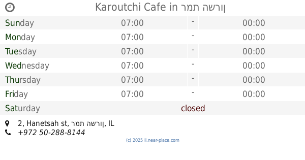
Karoutchi Cafe
Hanetsah st 2, רמת השרון
Cafe
Point of interest
Food
Establishment
read more
1.757 km
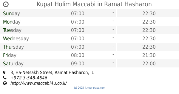
Kupat Holim Maccabi
Ha-Netsakh Street 3, Ramat Hasharon
Hospital
Health
Point of interest
Establishment
read more
1.821 km
מינימרקט אליעזר
Almagor Street 5, Tel Aviv-Yafo
Supermarket
Grocery or supermarket
Food
Store
Point of interest
Establishment
read more
1.833 km
סמטה
Keren ha-Yesod Street 43, Ramat Hasharon
Lodging
Point of interest
Establishment
read more
1.936 km
רופא שיניים ברמת השרון
Ussishkin Street 22, Ramat Hasharon
Dentist
Point of interest
Health
Establishment
read more
2.027 km
דר אריאלה נוצר
Beit El Street 39, Tel Aviv-Yafo
Dentist
Health
Point of interest
Establishment
read more
2.029 km
Dr. Amir Gazmawe
Ussishkin Street 37, Ramat Hasharon
Dentist
Health
Point of interest
Establishment
read more
2.046 km
אוצר החייל רמת השרון הסייפן
HaSaifan Street 33, Ramat Hasharon
Bank
Finance
Point of interest
Establishment
read more
2.101 km
אלמה:מרקט
Ussishkin Street 62, Ramat Hasharon
Supermarket
Grocery or supermarket
Food
Point of interest
Store
Establishment
read more
2.126 km
BWHITE | DR. MIKI BABAYEV
Ussishkin Street, Ramat Hasharon
Dentist
Health
Point of interest
Establishment
read more
2.243 km
מירב מרכז רפואי (בבנייה)
2228 Street, Tel Aviv-Yafo
Hospital
Health
Point of interest
Establishment
read more
2.655 km
דר עיניים
Sokolov Street 65, Ramat Hasharon
Hospital
Health
Point of interest
Establishment
read more
2.657 km
דר גיא מגנאג'י - רופא שיניים מומחה לילדים
Sokolov Street 81. 10, Ramat Hasharon
Dentist
Doctor
Health
Point of interest
Establishment
read more
2.699 km
Yoni 71
Sokolov Street 71, Ramat Hasharon
Restaurant
Food
Point of interest
Establishment
read more
2.725 km
ג'לידו גלידה ארטיזנלית רמת החייל Gelido artisinal ice cream Ramat Hahayal
ישראל 24, Raoul Wallenberg, Tel Aviv-Yafo
Cafe
Food
Point of interest
Store
Establishment
read more
📑
all categories
Accounting
Administrative area level 1
Administrative area level 2
Airport
Amusement park
Aquarium
Art gallery
Atm
Bakery
Bank
Bar
Beauty salon
Bicycle store
Book store
Bowling alley
Bus station
Cafe
Campground
Car dealer
Car rental
Car repair
Car wash
Casino
Cemetery
Church
City hall
Clothing store
Colloquial area
Convenience store
Country
Courthouse
Dentist
Department store
Doctor
Electrician
Electronics store
Embassy
Establishment
Finance
Fire station
Florist
Food
Funeral home
Furniture store
Gas station
General contractor
Grocery or supermarket
Gym
Hair care
Hardware store
Health
Hindu Temple
Home goods store
Hospital
Insurance agency
Intersection
Jewelry store
Laundry
Lawyer
Library
Light rail station
Liquor store
Local government office
Locality
Locksmith
Lodging
Meal delivery
Meal takeaway
Mosque
Movie rental
Movie theater
Moving company
Museum
Natural feature
Neighborhood
Night club
Painter
Park
Parking
Pet store
Pharmacy
Physiotherapist
Place of worship
Plumber
Point of interest
Police
Political
Post office
Premise
Real estate agency
Restaurant
Roofing contractor
Route
Rv park, camping
School
Shoe store
Shopping mall
Spa
Stadium
Storage
Store
Subpremise
Subway station
Supermarket
Synagogue
Taxi stand
Train station
Transit station
Travel agency
University
Veterinary care
Zoo
administrative area level 3
administrative area level 4
sublocality level 1
↑